
Twenty years ago, on June 23, 2001, a massive Mw 8.4 subduction zone earthquake struck Peru’s southern coast near Arequipa, about 370 miles southeast of Lima. Strong shaking was observed in many parts of southern Peru, northern Chile, and Bolivia. Ground acceleration in Arequipa, about 120 miles inland from the epicenter, was not accurately recorded due to instrument failures, although several reports indicated that the ground shook for about 60 seconds; a peak ground acceleration of 0.29g was recorded at Moquegua. The earthquake remains 19th on the list of the 20 Largest Earthquakes in the World compiled by the United States Geological Survey (USGS). Dozens of strong aftershocks shook the region.
Tectonic Setting
South America is one of the most seismically active areas of the world. It is located along the southeastern circum-Pacific seismic belt, which consists of six tectonic plates and accounts for nearly 75% of the total seismic energy released globally each year. Western and northern South America are dominated by active plate boundary zones characterized by rapid deformation, which is due to the convergence of the Nazca and Caribbean plates with the South American Plate—northwestern South America is one of the few places in the world where three subducting slabs are located in very close proximity to one another.
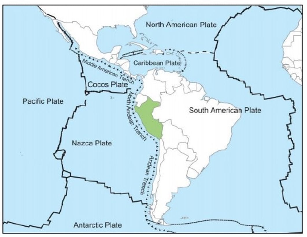
Peru is located on the western edge of the South American Plate where it meets the Nazca Plate, which is actively subducting beneath the South American Plate starting at the Peru-Chile Trench, located approximately 100 to 200 kilometers (62 to 124 miles) offshore (Figure 1). This region is very seismically active, with tectonic research and historical earthquake data indicating that the part of the subduction zone off Peru's southern coast is more active than the area to the north. Consequently, most of the large earthquakes in Peru have occurred off the southern shore. The Mw 7.7 quake in 1996 that struck southeast of the 2001 earthquake even appears to have ruptured part of the fault segment that produced the very large Arica earthquake in 1868, which is estimated to have had a magnitude of about Mw 8.5.
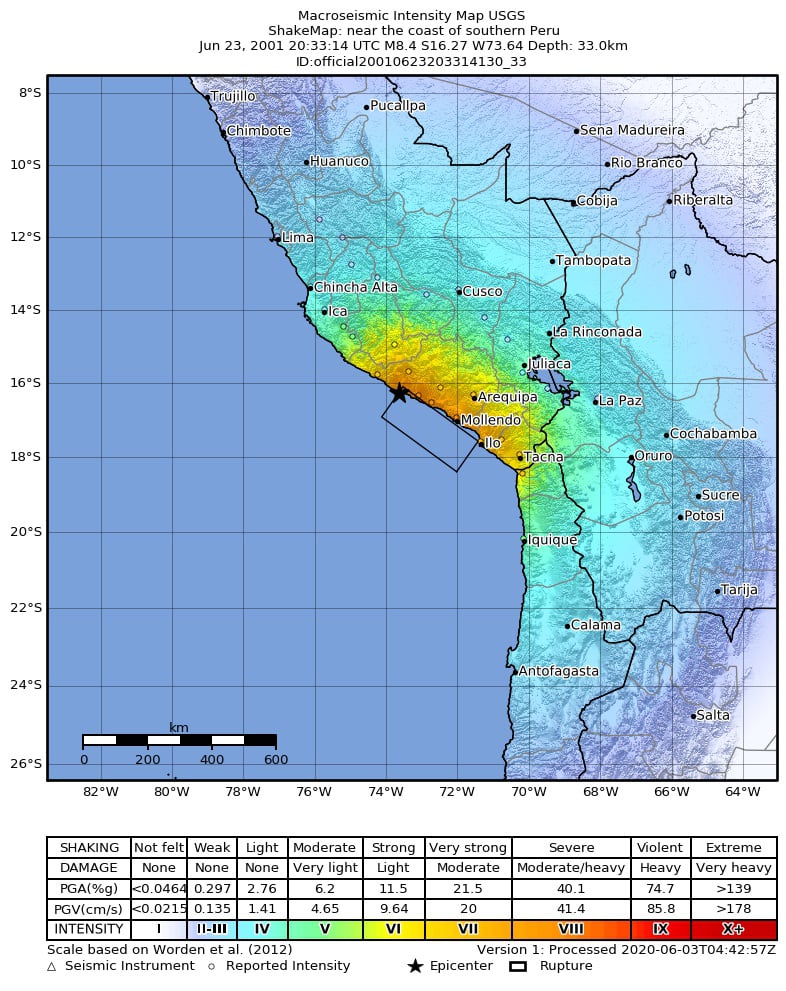
In the general Arequipa-Camaná-Tacna coastal area, 83 people were killed and 3,812 were injured. In all, 22,052 homes were destroyed or demolished and a further 33,570 reported damaged. Arequipa’s most important symbol and cultural and religious structure, Basílica Catedral, sustained heavy damage, including a collapsed tower. Other older historic structures were heavily damaged, including many with roofs constructed of sillar (blocks made of volcanic ash) supported with steel beams. In Camaná, most of the shake damage was restricted to adobe houses, although some school buildings were also damaged. Most of this was due to soft stories, but in schools short columns contributed to structural failures. The newer schools, built according to Peru’s building code, fared better and only suffered minor damage. South of Camaná, at least 50 landslides blocked highways (including the Pan American highway) and buried houses.
Tsunami
In addition to ground shaking the earthquake caused a tsunami that killed 26 people and destroyed about 2,000 buildings along 30 kilometers of the coastline (Figure 3). About 20 minutes after the mainshock three waves reached the coastal resort of Camaná, about 66.5 miles from Arequipa. Runup heights in the vicinity reached 7 meters at some locations and water penetrated as far as 1 km inland in places. The 1868 Arica earthquake also produced a tsunami, and on that occasion an estimated 25,000 people died along the South American coast. The 1868 tsunami impacted locations as far away as Hawaii, where it caused severe damage. It also reached Japan, Australia, and New Zealand, where it struck the northwest coast of Chatham Island; it remains the only tsunami to have killed anyone in in that country.
Vulnerability and Resilience
Peru is prone to very large earthquakes. The country’s records, which date as far back as 1553, contain more than 70 significant events since 1568. The capital, Lima, is located midway along the Peruvian coast and its metropolitan area contains about a third of the country’s population and 70% of its industry. Earthquake vulnerability varies across Lima and the surrounding region for several reasons. For example, in commercial and high-income residential areas, homes and businesses are well built and population density is low. Buildings in such regions would likely experience less damage than buildings typical of Lima’s inner city, which are characterized by adobe construction and tiled roofs—construction highly vulnerable to the effects of earthquakes. In addition, many towns outside of Lima contain adobe structures and are built on alluvial fill, which can amplify ground motion and exacerbate damage from ground shaking.
While Peru's building codes are now quite good, many commercial structures in the region predate them and most residential structures in the country are unlikely to have been built in compliance. Although it has many vulnerable buildings, the region has little in the way of insurance protection. While it does little to make older structures safer, the effective implementation of appropriate building codes enables new construction to perform better during earthquakes and saves lives. It also makes those new buildings insurable, and insurance—if it is available and purchased—can make an enormous contribution to a community’s resilience, helping it to recover sooner.
Reliably assess and manage seismic risk with AIR earthquake models.