


Tsunamis are a coastal phenomenon and New Zealand is no stranger to the peril. A thorough review of historical tsunami records indicates that New Zealand is not only vulnerable to local and regional tsunamis but also to tsunamis generated by distant trans-ocean basin earthquakes.
Most recently, a tsunami warning was issued for New Zealand after an M7.0 earthquake struck the Kermadec Islands region in the Pacific Ocean on June 16, 2019. Fortunately, on this occasion it was later declared that there was no imminent threat to the country. But next time might be very different.
A Threat from Afar
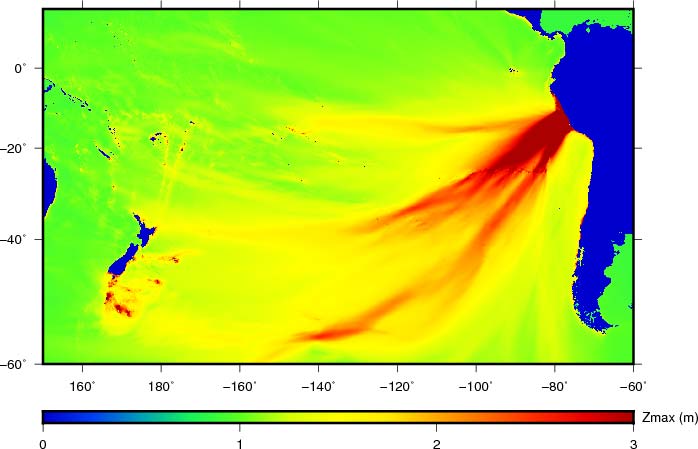
Tsunami wave amplitudes, unlike high frequency seismic wave amplitudes, do not necessarily decay with distance and can amplify as they approach continental shelves and coastal areas. Consequently, flooding can occur not only due to tsunamigenic earthquakes close to shore but also due to large earthquakes hundreds or even thousands of kilometers away (Figure 1).
The 2004 M9.1 Sumatra-Andaman earthquake in Indonesia generated a devastating and far-reaching tsunami that caused significant coastal flooding in parts of India, Sri Lanka, and Somalia, 1,500 to 5,000 km away, killing thousands of people. Similarly, the 2011 M9.1 Tohoku earthquake in Japan caused insured losses along the Hawaiian Islands and the western coast of the United States.
A Trans-Ocean Basin Tsunami Model
To quantify the risk of flooding along the coastline of New Zealand, AIR scientists have developed a probabilistic tsunami hazard model. We did this by numerically simulating the origin, propagation, and runup of tsunamis caused by ~500 earthquakes with magnitudes greater than 7.0 from a unified, 10,000-year, time-dependent, synthetic seismic catalog, developed as part of regional probabilistic seismic hazard analyses.
The model incorporates single and multi-segment fault rupture scenarios with variable slip, high-resolution (90-meter or better) bathymetry/elevation data, variable Manning coefficient maps derived from high-resolution land-use/land-cover data sets, levee location, and height data (where available). We also ensured a contribution from astronomical tides, to estimate maximum inundation depths and wave velocities along the coastline(s).
The model not only includes local tsunamigenic sources, such as crustal and subduction zone faults along the Hikurangi and Puysegur trenches but also those in the far-field, i.e., those associated with subduction along the Kermadec-Tonga, New Hebrides, and Peru-Chile trenches.
Coastal Impact
It is important to remember that tsunamis can cause significant loss without any ground shaking. Figure 1 shows the maximum wave height following a large simulated M9.18 earthquake offshore central Peru. Note the strong directivity of energy toward New Zealand where ground up losses potentially as high as NZD 1 billion, could occur.
Because tsunami waves are typically characterized by a series of crests and troughs, there can be multiple inundations during a period of several hours, which can flood/damage residential/commercial buildings, agricultural land, and coastal infrastructure, including port facilities and marinas.
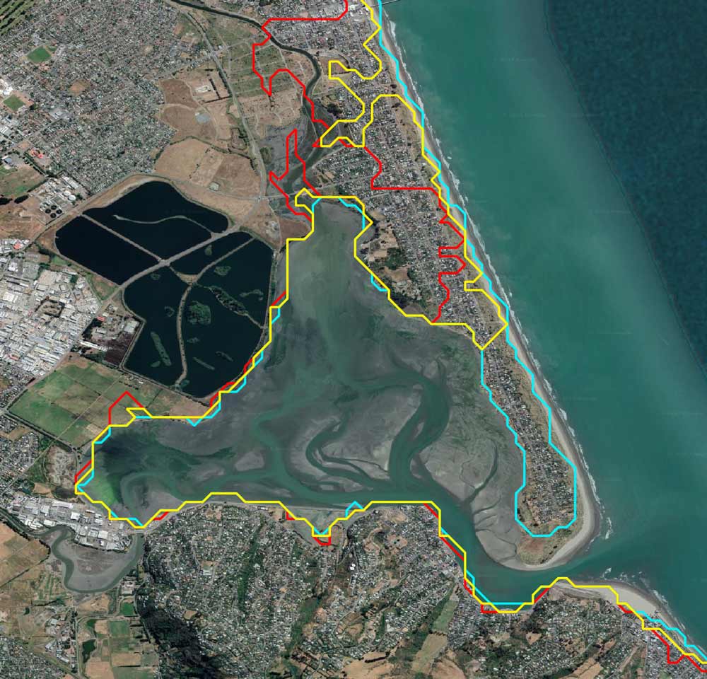
AIR has developed the first probabilistic trans-ocean basin tsunami model for New Zealand, which enables users to capture the risk to New Zealand’s dense coastal and marine exposures from local as well as far-field tsunamigenic earthquakes. Figure 2, for example, shows the water inundation extent near the suburb of Southshore within Christchurch for a mean return period of 475 (cyan), 2,475 (yellow), and 10,000 (red) years, which correspond, respectively, to a 20%, 4%, and 1% probability of exceedance over a 100-year period.
Ever since the first European settlements two centuries ago New Zealand has experienced several tsunamis, with some of the most significant resulting from earthquakes occurring off the coasts of Chile and Peru. The updated AIR Earthquake Model for New Zealand provides the most up-to-date and comprehensive view of earthquake risk and enables stakeholders to prepare for and mitigate potential future impacts with confidence.


