


The 2010 Haiti Earthquake: From Devastation to a Deeper Understanding of Caribbean Seismicity
Jan 06, 2020
Editor's Note: AIR plans to release a substantially updated earthquake model for the Caribbean this summer. This article provides an overview of the enhancements to the hazard module, including a discussion on how new data about the Caribbean’s seismotectonics gathered in the past 10–20 years has been leveraged by AIR to enhance our ability to quantify seismic risk across the region, and how AIR models the newly added sub-perils of tsunami and liquefaction.
The Caribbean is very seismically active and has the potential, geologically, to generate large, destructive earthquakes. Just 10 years ago this month, an M7.0 earthquake struck Haiti, leveling Port-au-Prince, destroying homes and infrastructure, displacing millions, killing hundreds of thousands, and causing billions in economic loss, which demonstrates the destruction that Caribbean earthquakes of even moderately large magnitudes can cause.
The impact of the 2010 earthquake has been devastating for Haiti; more than 200,000 people died and an additional 300,000 sustained earthquake-related injuries. While it is impossible to quantify the toll this earthquake has had, at AIR we quantify what we can to make sense of natural disasters such as this not only to model the risk better but also to promote resilience. Since 2010, seismometers, accelerometers, and GPS recording stations have been installed and field surveys have been performed to understand the fault geometries at work both on land and offshore, all of which has provided new data that can be leveraged to better understand the tectonic complexity of the Caribbean and more accurately model the risk in the updated AIR Earthquake Model for the Caribbean, anticipated for release this summer.
Understanding the Plate Tectonics of the Caribbean
The Caribbean Plate is bounded by the Cocos Plate on the east, the North American Plate on the north and east, and South American Plate on the south (Figure 1); GPS data show an overall convergence rate between the North American Plate and the Caribbean Plate of ~20 mm/year. The northwestern edge of the Caribbean Plate is made up of east-west trending faults and a spreading axis. As the faults extend eastward from the spreading axis, they define a microplate between Jamaica and Cuba. Jamaica absorbs most of the plate motion between the Caribbean Plate and the microplate, resulting in large strike-slip faults that cross through the center of the island and continue offshore onto the Tiburon Peninsula of mainland Haiti. The largest of these faults, the Enriquillo-Plantain Garden fault zone, poses a significant seismic risk to both Jamaica and Haiti because it can produce a large strike-slip earthquake in densely populated areas such as Kingston, Jamaica, or Port-au-Prince, Haiti—where significant impacts of the 2010 quake were experienced.
 Megan Zimmerman, Ph.D.
Senior Scientist I
Edited by Rachel Wisch, CEEM
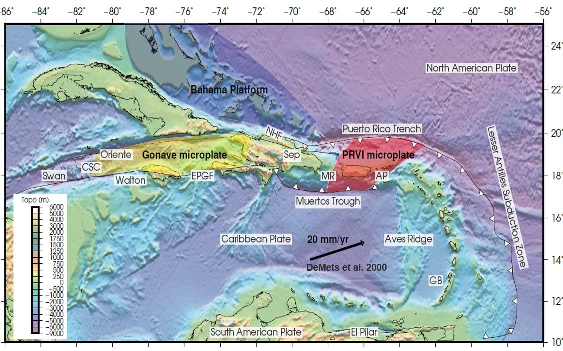
North of Hispaniola, the convergence between the North American and Caribbean plates manifests as the North Hispaniola Fault. This fault was the source of the damaging 2003 M6.4 Puerto Plata earthquake, which impacted the northern Dominican Republic. Farther east, this convergence becomes more complex along the Puerto Rico Trench where the North American Plate is subducting (traveling beneath) the overriding Caribbean Plate. Because Puerto Rico itself has very little seismicity, the island is mostly susceptible to earthquakes originating in surrounding fault sources such as the Puerto Rico Trench in the north, the Muertos Trough in the south, and rift zones to the east and west. In the northeastern corner of the Caribbean, the Puerto Rico Trench transitions to the Lesser Antilles subduction zone, a region of convergence that continues southward for 3,500 km; there is currently debate about whether this subduction zone has the capability of producing a large megathrust earthquake or if it is releasing accumulated strain through aseismic creep.
The tectonic history of the Caribbean Plate boundary with the South American Plate is highly complex. Although there have not been any large, shallow earthquakes along the very southern portion of the Lesser Antilles subduction zone in recorded history, deep seismicity is consistently observed in this region. The subduction zone ends to the northeast of Trinidad, where its motion is transferred to the Central Range Fault (CRF) that runs through the middle of the country. Recent paleoseismic excavations across the CRF by the United States Geological Survey (USGS) suggest that, in Trinidad, this fault has the potential of generating damaging earthquakes.
New Data Inform Time-Dependent Modeling and Multi-Fault Rupture Scenarios in the Caribbean
Recent paleoseismological studies, marine surveys, and GPS data have provided new insights into seismicity in the region that inform a significantly updated fault model. Certain faults, where more detailed data are available (such as slip rates and fault geometries), as well as known historical ruptures can be modeled as time-dependent. A time-dependent view of seismicity accounts for the buildup of strain on faults over time and how that could impact the likelihood, occurrence rate, and rupture size of potential earthquakes in the future.
These new fault data along with a more comprehensive understanding of the tectonics of the Caribbean region overall allow researchers to better identify faults that may rupture in multi-segment ruptures, during which an earthquake ruptures multiple faults. This is especially important when modeling complex subduction zones such as the Puerto Rico Trench and Lesser Antilles. The entire subduction zone is made up of fault segments, and large earthquakes are possible along sequences of neighboring segments in multi-fault rupture scenarios. The ability to identify potential fault interaction/triggering, as well as fault spacing and orientation, is critical to accurately modeling Caribbean seismicity.
New GPS data also enabled a 2014 update to the Global Strain Rate Model (GSRM v2.1), a global model for active crustal deformation along plate margins developed by a consortium of research institutions. The GSRM v2.1 allows the quantification of the rate of strain accumulation throughout the Caribbean, which informs seismic hazard analysis.
Significant Updates to Ground Motion Simulation, Soil Maps, and Liquefaction Susceptibility
Due to very limited ground motion observations from regional Caribbean networks, modeling ground motion footprints for various types of earthquakes in the Caribbean requires a good understanding of the regional geological, geophysical, and tectonic environment and the types of earthquakes that can occur. While no reliable empirical ground motion prediction equations (GMPEs) have been specifically derived from local data, many global GMPEs have been developed using data from comparable tectonic environments. Based on detailed analysis of the tectonic environment, AIR developed a ground motion model for each type of earthquake in the Caribbean from the latest available global GMPEs. The model was validated using data recorded from recent earthquakes such as aftershocks following the 2010 M7.0 Haiti earthquake and the 2018 M7.3 earthquake that occurred north of Venezuela recorded in Trinidad and Tobago.
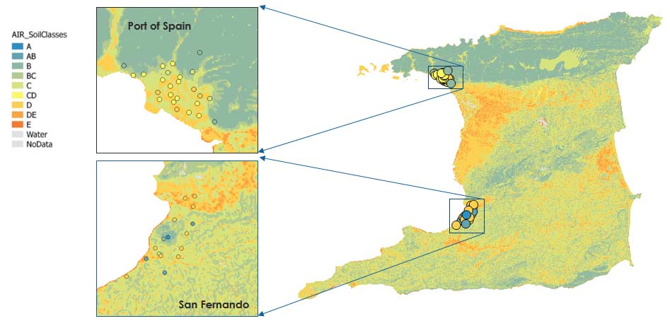
Ground motion can be amplified or dampened by as much as two- or threefold depending on the soil type at the affected location. To capture the effect of soil, AIR developed detailed soil maps for the Caribbean from various data, including high-resolution geological data, aerial imagery, and digital topographic data. For large population centers, high-resolution soil maps of up to 30 meters were developed to accurately account for risk variation due to the impact of soil. The soil maps are extensively validated using available observations on soil shear wave velocity or site classification (Figure 2).
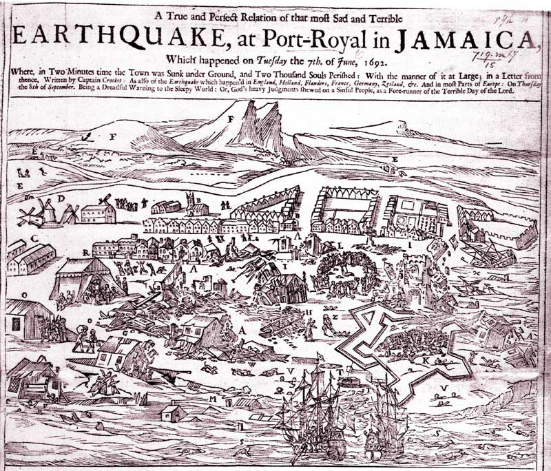
Soil type also directly impacts the potential for liquefaction, a geophysical phenomenon that occurs when saturated or unconsolidated soils lose strength and stiffness due to intense ground shaking, causing the soil to behave as a liquid that is unable to support weight. In the Caribbean, many islands have expanded their coastlines through land reclamation, a process that creates new land from the seabed. Port facilities are especially susceptible to liquefaction risk because they are often filled with dredged materials that are poorly consolidated. The island most at risk for liquefaction in the region is Jamaica, as the 1692 M7.5 earthquake, which destroyed the man-made island of Port Royal, illustrates (Figure 3).
It is not unrealistic for such a devastating event to recur. Current soil data reveal that many large population centers in the Caribbean are underlain by the softest soil classification, making them susceptible to liquefaction. Kingston, Jamaica, is the Caribbean city most susceptible to liquefaction; 80% of Kingston is classified as having moderate to very high liquefaction susceptibility. Other Caribbean cities with high vulnerability are typically located on the coast; San Juan, Puerto Rico, for example, has 30% moderate to very high liquefaction susceptibility.
Lessons learned from developing the AIR Earthquake Model for New Zealand, which involved extensive liquefaction research following the February 2011 M6.2 Christchurch earthquake, have been adopted in the liquefaction module of the AIR Earthquake Model for the Caribbean. In-house liquefaction susceptibility maps were developed for each of the 29 Caribbean countries modeled. These data, along with groundwater maps and characteristic soil profiles, were used to determine potential liquefaction damage for a given level of ground shaking. The updated model provides liquefaction coverage for the entire model domain at 90-meter resolution.
Caribbean Coastlines Prove Susceptible to Tsunami Inundation
In addition to liquefaction, coastlines in the Caribbean are susceptible to tsunami inundation. In fact, nearly all Caribbean island nations have experienced tsunamis resulting from one or more of the following: tectonic sources (both local and far-field); submarine landslides; and/or volcanic eruptions. The most recent destructive tsunamigenic earthquake to impact the Caribbean occurred in August 1946 just north of the Dominican Republic. Since then, there has been an increase in both coastal population as well as coastal development in nearly all Caribbean nations, as well as an overall increase in tourism. The tectonic setting of the Caribbean makes these coastal areas vulnerable to tsunami risk.
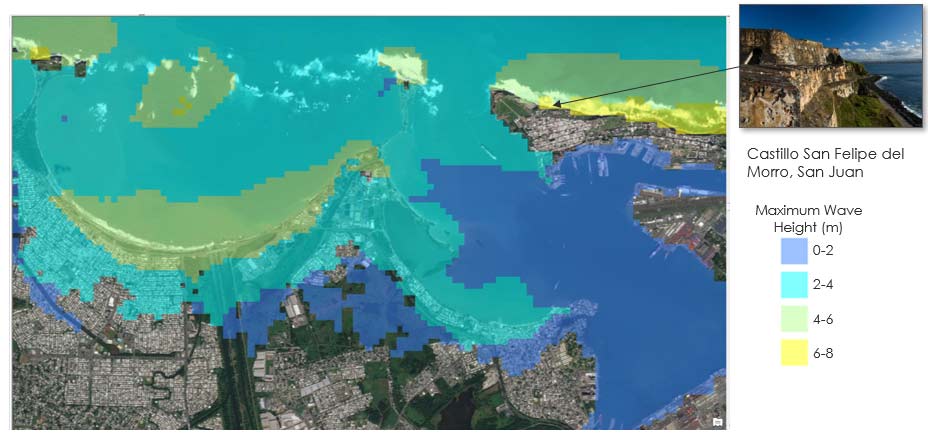
Using local tectonic sources and updated nonlinear shallow water equations, AIR was able to evaluate wave propagation from the source to onshore locations through both deep ocean water and near-shore shallow water. While accurate tsunami wave height from detailed tsunami modeling is important, loss due to tsunami is directly related to the difference between wave height and elevation, or the inundation depth. Since elevation can vary substantially over short distances, an accurate tsunami risk assessment model requires high-resolution elevation data in addition to a detailed tsunami wave model. AIR’s tsunami model for the Caribbean has a spatial resolution of 90 meters and captures many details of the coastal landscape. For example, the coastal cliff of Castillo San Felipe del Morro, a citadel promontory sitting 140 feet above sea level in San Juan, is not inundated when simulating an M8.3 subduction earthquake in the Puerto Rico Trench (Figure 4), whereas a low-resolution model that does not account for elevation could have completely inundated that location.
Managing Caribbean Earthquake Risk
The updated AIR Earthquake Model for the Caribbean incorporates the latest seismological research and reflects the most up-to-date understanding of the Caribbean’s seismic hazard. The updated model spans all 29 countries that make up the Caribbean and shares a 90-meter resolution industry exposure database that includes high-value exposures, such as luxury hotels and resorts, with the updated AIR Tropical Cyclone Model for the Caribbean, also anticipated for release this summer.
The model was developed using the most comprehensive and up-to-date historical and instrumental earthquake catalogs from both local and global agencies. The latest geotechnical data, field survey data, and innovative methodologies were used in the development of the AIR Earthquake Model for the Caribbean to ensure the most robust results possible, which have been extensively validated. With the newly added sub-perils of liquefaction and tsunami, the upcoming AIR Earthquake Model for the Caribbean provides a more detailed and accurate view of the risk associated with the impacts from earthquakes for more effective risk management.
