


Typhoon Vera's 60th Anniversary: Why Japan Re-evaluated Disaster Prevention
Sep 17, 2019
Editor's Note: September 2019 marks the 60th anniversary of Typhoon Vera, the most destructive typhoon ever to strike Japan. A significant portion of the damage was the result of storm surge and in the years following Vera's landfall, Japan responded by fortifying the entire country against future storm surge events with a comprehensive levee system. In this article, we take a look back at Typhoon Vera and what Vera’s impact would be if it were to recur with today’s defenses and without them.
A Most Destructive Typhoon
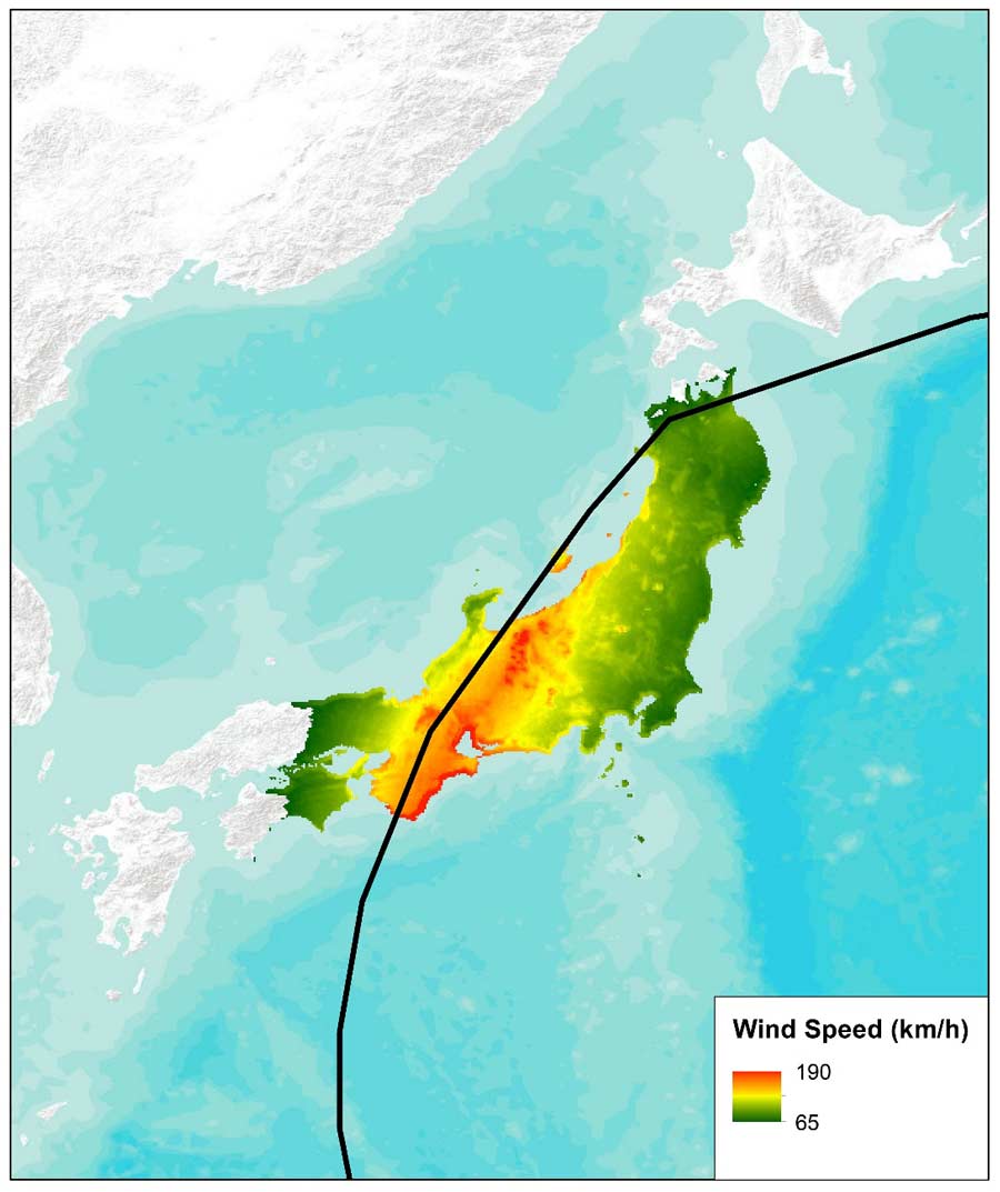
On the eve of the landfall of Japan's most destructive typhoon, newspaper headlines were unexceptional: "Typhoon will approach tomorrow night" and "Tokai in range of severe winds in the afternoon" are representative. The following evening, September 26, 1959, a monstrous Category 4 storm with winds near 240 km/h came ashore west of Ise Bay in south-central Japan. The storm was dubbed Vera.1 Its record-high storm surge crashed over sea walls and breached coastal dikes that were hundreds of years old. Vera moved northeast over land toward Ise Bay, where its winds drove bay water toward Nagoya Port. The port experienced storm surge of nearly 4 meters at 9:35 p.m. local time. Dikes caved immediately, giving people in Nagoya and surrounding villages little time to flee. The city of Nagoya was devastated in just three hours; its harbor—strewn with bodies, debris, and timber from a local timber factory—was subsequently described as a "sea of dead."
Vera tracked quickly across Honshu, losing little strength over land. In the small village of Nagano in central Japan, high winds ripped the roofs from hundreds of traditionally constructed wooden homes. Heavy precipitation swelled rivers so greatly that they spilled over their banks. Landslides were widespread. Conditions remained treacherous even after Vera's departure. Muddy water continued to pour through breaches in dikes on the south-central coast for several days until they were finally repaired. Because the area just north of Ise Bay is at or even below sea level, some districts remained flooded even 100 days after the storm.
Altogether, Typhoon Vera flooded more than 360,000 homes, of which 190,000 were submerged2 (Oda, 2006). Another 830,000 homes sustained some level of damage. The storm killed an estimated 5,000 people and injured 66,000. Much of the damage was in Aichi and Mie prefectures. AIR estimates if Vera were to recur today, it would result in insured losses of approximately JPY 1,943 billion (USD 17.7 billion), caused mostly by wind (JPY 1,819 billion, USD 16.63 billion). By comparison, industry estimates for industry losses resulting from September 2018’s Typhoon Jebi (also primarily a wind event) hovered around USD 13 billion as of May 2019.
Impact on Japan's Disaster Awareness and Insurance Industry
Japan is prone to natural disasters and the decade that followed World War II saw numerous large-scale events, including the Nankai earthquake in 1946, Typhoon Kathleen in 1947, the Fukui earthquake in 1948, Typhoon Ida in 1958, and Vera in 1959. These events left thousands dead, and although comprehensive plans to improve river flood measures for Greater Tokyo had begun after Ida, Typhoon Vera was the catalyst for developing and strengthening the disaster management system in Japan and undertaking a massive effort to strengthen coastal and inland flood defenses throughout Japan.
On September 27, even as Vera was still unfolding, local governments set up disaster relief headquarters and invoked the Disaster Relief Act. Refuge shelters were opened and victims were rescued using helicopters and boats. On September 29, the national government got involved, creating the Central Japan Disaster Relief Headquarters. Defense forces joined in evacuation efforts, and truckloads of food and shelter items poured in from around the country.
Immediately after the storm, the government launched a full-force rebuilding initiative. Within a few months, the Law for Special Measures to Promote Storm Surge Protection was passed to implement measures for the protection of land and people from storm surge; other legislation addressed threats from inland flooding. Permanent restoration works began as part of a five-year plan, and 2 million people were put to work on the embankments of rivers and coasts. Workers built an 8-km long dike around Nagoya Port and surge defense systems were constructed on other major bays in Japan, including those in Tokyo and Osaka. These systems were designed to handle water levels based on the storm surge produced by Typhoon Vera. Measures were also put in place to reduce the rate of land sinking around Ise Bay from underground pumping activity—which had been about 10 cm per year by the time Vera struck.
The Disasters Countermeasures Act required annual reports on prevention-related activities and promoted public awareness through the annual observance of Disaster Prevention Day. At the local level, government officials and citizens began participating in Disaster Management Councils and drafted disaster management plans specific to their regions.
Vera's destruction marked a turning point in Japan's approach to coping with catastrophes. Previously, Japan had been response-oriented. In Vera's aftermath, the focus was on prevention. Officials invested in upgrades for disaster information communication systems, as well as improvement of weather observations and forecasting technologies.
Vera ultimately had a tangible impact on the insurance industry; it became the event used by insurers and reinsurers to define the reserve for a 70-year return period event. An amendment to the enforcement regulations of the Insurance Business Law on April 1, 20053, requires insurers to base their catastrophe reserves for windstorm or flood on recurrence of Typhoon Vera. This increased the minimum windstorm return period for reserving and reinsurance purposes from 20 years to 70 years.
 Anna Treviño, Ph.D.
Senior Scientist II
 Peter Sousounis, Ph.D.
VP, Climate Change Research
Edited by Sara Gambrill, CEEM
Managing Japan Typhoon Risk
To prepare for disasters such as Typhoon Vera, one must understand the range of possible losses—before they occur. The AIR Typhoon Model for Japan shows how accurately Vera’s storm surge hazard can now be modeled. The model’s catalog includes Vera as a historical event and two additional scenarios: a Realistic Disaster Scenario (RDS), which is a recurrence of Vera with today’s existing levee system; and an Extreme Disaster Scenario (EDS) that is a recurrence of Vera with no levees. To create the wind field for modeling the surge in these scenarios, AIR performed a simulation of Vera over water using the AIR Typhoon Model for Japan. Best track data from the Japanese Meteorological Agency was used to generate hourly wind speeds and wind directions, which were then fed into SuWAT (see box) along with observed tide values.
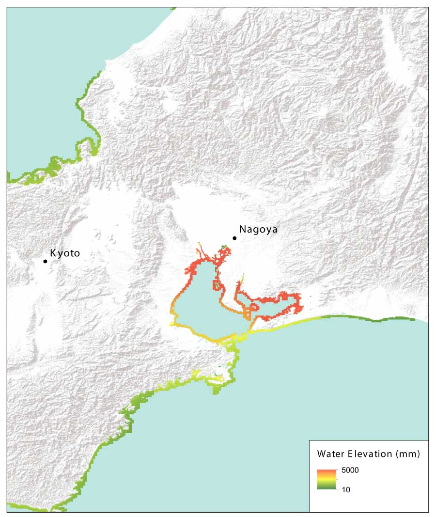
RDS: A Recurrence of Vera with Present-Day Levee System
The RDS modeled the meteorological aspects of Vera exactly as they occurred throughout the storm's lifetime and the present-day levee system around Ise Bay—but assumed widespread collapse at some point during the event. The flood footprint in Figure 2 represents the situation after the levees collapsed, showing the water elevation (in mm). Areas experiencing flooding include the Port of Nagoya, small portions of land along the Kiso and Ibi rivers, and areas of Tahara Bay near the city of Toyohashi.
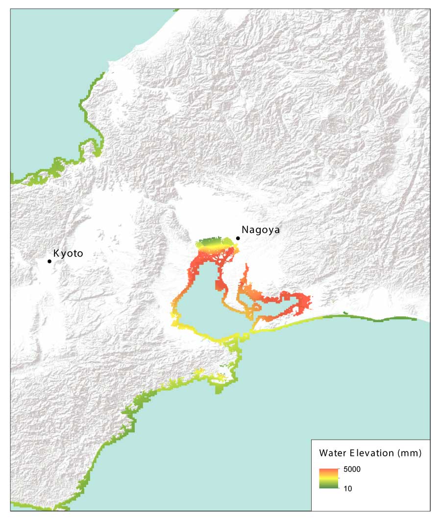
EDS: A Recurrence of Vera Without Levees in Place
The EDS was modeled to explore what would happen if Vera were to recur with no levees. In the Japan Typhoon model, levees are implemented based on information from the Japanese government. For this simulation, terrain height was used in place of levee height, as if a levee did not exist in the regions provided by the Japanese government. As one would expect, inland penetration of water from the EDS is much more extensive than in the RDS. Not only is the area between the Kiso River and the City of Nagoya flooded in the EDS, but also much of the cities of Toyohashi and Nishio. In addition, the Chubu Centrair International Airport, located on an island in Ise Bay, is entirely under water. From a loss perspective, however, it should be remembered that that there is more exposure in the region than there was in 1959. It should also be noted that the farthest inland penetration of floodwater is just west of Nagoya City.
Typhoon Vera is just one example of the extensive and widespread damage typhoons can produce in Japan and around Tokyo.
Ultimately, catastrophe models—such as the AIR Typhoon Model for Japan—help organizations evaluate the full range of potential events so that they can manage the risk effectively; understand how those events will impact them; and mitigate losses and enhance resilience through planning and engineering.
1 The Japan Meteorological Agency, which assigns numbers rather than names to typhoons, made an exception in this case after the fact, calling it the Isewan Typhoon because of its destruction of the Ise Bay (wan) region.
2 Submersion indicates flooding to the first floor level.
3 Privatization of the Japanese insurance market didn't happen until 1996, and regulating catastrophe reserves was not a priority until nine years later in 2005, the year after 10 typhoons—more than twice the annual average—made landfall in Japan.
