


An Enhanced View of Hurricane Wind and Storm Surge Risk in the U.S.
Jan 29, 2015
Editor's Note: In summer 2015, AIR is releasing several important enhancements to the U.S. hurricane model. This article provides an overview of the enhancements, and future articles will delve into some of the details.
Introduction
The AIR Hurricane Model for the United States has been a robust and comprehensive tool for managing hurricane losses since it—and AIR—launched the catastrophe modeling industry in the late 1980s. Because it draws upon a rich and extensive historical data set, AIR has been able to maintain a relatively stable and consistent view of risk throughout the model’s history, even as compelling new data and research are regularly incorporated. The model’s last major update was undertaken in 2010, and the 2015 model—scheduled for release this summer—will reflect significant research efforts over the past five years to better quantify hurricane risk.
In particular, AIR researchers have developed an enhanced storm surge module; incorporated recent high-resolution land elevation, land use, and land cover data; and accounted for published studies and damage and claims data (including for new building methods and materials, building codes, and improved flood defenses). These updates result in a well-rounded model that provides thorough risk analysis and withstands rigorous validation.
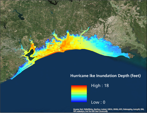
Dynamic Surge Inundation Modeling
As witnessed during major events in the U.S., including Hurricane Katrina and Hurricane Sandy, many hurricanes that affect the country are capable of producing devastating storm surges. Over the past decade, AIR researchers have conducted detailed analyses of the characteristics of storm surges, including the velocity of surge currents, and how surge inundation depth at a location is affected by land elevation and changes in land use/land cover.
While AIR’s previous storm surge model produced sound results, the availability of more computing power has enabled AIR researchers to create a high-resolution, hydrodynamic storm surge model. By incorporating the intensity, direction, location, forward speed, central pressure, and other parameters for each hurricane event—along with the unique geographic and physical features of the coast—storm surges can be modeled at a regional level, for all stochastic events. Combining all of these aspects enables AIR researchers to model the generation of the storm surge event in detail, which in turn leads to an accurate simulation of the surge inundation depth at a given location.
The new storm surge model will incorporate many aspects of NOAA’s well-established Sea, Lake, and Overland Surges from Hurricanes (SLOSH) model, a highly detailed model that accounts for storm parameters, coastal geography, coastline features, inland rivers, and flood defenses. By extending and customizing the capabilities of SLOSH, AIR researchers were able to produce surge inundation estimates that are appropriate for high resolution catastrophe modeling.
AIR’s model also accounts for tidal variation—which can affect inundation levels substantially—by incorporating seasonal and regional data based on the day, time, and location of landfall. Then, after creating a spatially consistent surge footprint, AIR applied a downscaling methodology to increase the resolution of modeled inundation using 30-meter resolution elevation data from the USGS National Elevation Dataset (NED).
 By: Dr. Tim Doggett
AVP, Principal Scientist
 By: Ann Weiner, CCM
Science/Technical Writer
Edited by Nan Ma, CCM
The article:
- The 2015 release of the AIR Hurricane Model for the United States will feature a new high-resolution hydrodynamic storm surge module and reflect the latest research on the effects of surge on property.
- Probabilistic modeling of flood defenses in New Orleans will account for storm surge intensity and the design of the current flood defenses.
- Updates to the wind model will feature explicit and detailed wind vulnerability assessments of large high-value homes and of mobile homes.
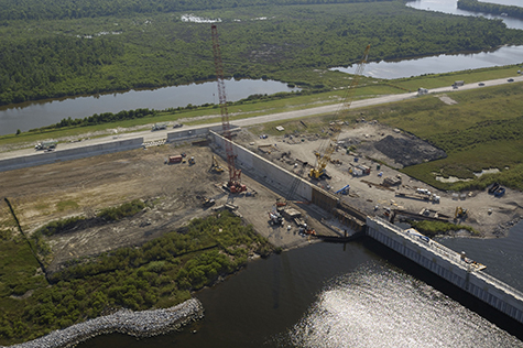
Probabilistic Modeling of Flood Defenses in New Orleans
When determining storm surge intensity at a location, the updated model will account for current flood defense data in all modeled states. Probabilistic flood defense failure will be modeled for the levees, floodgates, and other flood defense components that protect New Orleans, the only major U.S. city with polders, or areas that are fully enclosed by flood defenses. AIR is using the most recent data from the U.S. Army Corps of Engineers (USACE), whose design criteria for the new flood defenses in New Orleans provide protection for 100-, 250- and 300-year return periods, depending on the location of the defense.
To determine if and when a flood defense fails, the model will use probabilistic fragility curves, which are based on the event intensity and the design specifications of the affected flood defense. AIR’s fragility curves account for the probability of defense failure at loads below its design standard as well as the probability of the defense holding up against loads greater than its standard. Users simulating Hurricane Katrina for today’s exposures will be able to simulate the event using either today’s levees or those from 2005.
Storm Surge Vulnerability of Buildings and Automobiles
The steady increase in development along coastal areas over the years, environmental changes, and updates in flood defenses have had a profound effect on storm surge vulnerability in the U.S. Awareness of the increasing potential for storm surge losses has been heightened due to major events such as hurricanes Katrina, Ike, Irene, Rita, and Sandy. The extensive and highly detailed claims data from these events reflect the effectiveness of current flood defenses as well as the regional and temporal variation in building practices.
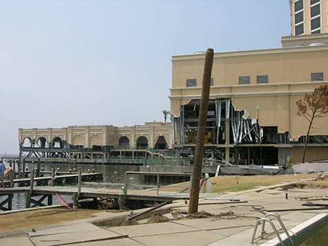
In addition to a thorough study of claims data, AIR engineers conducted post-hurricane damage surveys of the nature of storm surge damage on residential and commercial exposures, and on automobiles. The storm surge vulnerability assessment in the updated model will incorporate AIR’s findings from these damage surveys, analyses of detailed claims data, and insights from published literature.
AIR’s new storm surge damage functions use a component-based approach, reflecting the contribution of different building components to the building’s replacement value. AIR’s approach allows the model to provide robust estimates of damage at different levels of inundation, which can vary dramatically depending on building characteristics.
Apart from primary risk characteristics (including age, construction and occupancy class, and height), a wide range of secondary risk characteristics (including the type of foundation, number of basement levels, and service equipment protection) can be input into the model to further differentiate the vulnerability between different structures.
The efficacy of various modeling assumptions was validated by AIR’s participation in the 2014 USACE North Atlantic Coast Comprehensive Study (NACCS) Expert Elicitation Panel. The panel examined studies on flood risk reduction strategies, including research on storm surge vulnerability in the Northeast in the aftermath of Hurricane Sandy.
Observations from Hurricane Sandy indicated many complexities regarding the drivers of automobile vulnerability to storm surge; thousands of vehicles were damaged when multi-level underground garages were flooded in Manhattan, for example. In the updated model, an enhanced county level auto damage assessment will account for the degree of urbanization and the proportion of basements in mid- and high-rise buildings in addition to evacuation characteristics. A distinction is made between free standing automobiles to those in auto dealerships.
New High-Resolution Data on Hurricane Wind Hazard and Vulnerability
In 2012, the National Oceanic and Atmospheric Administration (NOAA) released an update to its North Atlantic Hurricane database to improve best track data for historical storms (including time, location, and wind intensity at landfall). AIR scientists have used the revised database, called HURDAT2, to update the AIR model’s historical and stochastic catalogs.
The AIR model accounts for increasing urbanization and new land use/land cover classifications, which can affect the calculation of both wind and flood damage. This high-resolution information on the physical properties of the land surface comes from the latest version of the National Land Cover Database (NLCD 2011) from the United States Geological Survey (USGS).
The model will also include important updates in its wind vulnerability assessment. Homes that conform to the Institute for Business and Home Safety (IBHS) Fortified Home program can be designated as such, and the published recommendations of the standard have been incorporated into the model. Additionally, the model will account for the 2012 International Building Code (IBC) adoption in Alabama for residential construction.
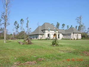
Vulnerability of Large Homes
Large, high-value homes generally exhibit high quality construction (often with sophisticated engineering input) and maintenance. They may feature complex architecture with elaborate roof geometries containing multiple gable ends and corners. Wind damage to roofs is often the result of vortices in the wind flow pattern, which form at roof corners and create a suction force. Large roof areas with a complex configuration tend to disrupt the wind flow, resulting in lower wind speeds and weaker suction forces. The combination of high quality construction and lower wind speeds generally reduce the wind vulnerability of large homes.
AIR engineers have investigated the impact of home size on wind damage using computational fluid dynamics (CFD) and have incorporated their findings into the updated model. The assessment accommodates multi-storied architecture by basing the home size on the livable square footage rather than its footprint.
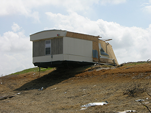
Mobile Homes
At the other end of the spectrum from large high-value homes are mobile homes. Due to their light weight, flat side construction, and foundation tie-downs, mobile homes are highly vulnerability to wind damage, even higher than formerly believed, according to recent studies of claims data. On the other hand, the newest mobile homes are built under more stringent guidelines, which include more secure foundation connections.
AIR engineers completed an investigation of mobile home vulnerability that includes the effects of the year of manufacture and regionality, as well as environment deterioration. These factors incorporate design requirements and wind resistance zones established by the U.S. Department of Housing and Urban Development (HUD).
Closing Thoughts
The view of hurricane risk in the United States has been refined by continued research on both wind and storm surge characteristics, along with improved flood defenses and construction guidelines. Recent major events have also increased the awareness of the importance of hurricane wind and storm surge coverage, across all coastal areas from Texas to Maine. With this update, AIR has incorporated the latest research and data into the AIR Hurricane Model for the United States, and fully validated the results. Insurers can continue to rely on the model as the industry standard, providing a robust assessment of the risk from hurricanes.
