


The United States’ Aging River Levees
Nov 20, 2014
Editor's Note: There are nearly 100,000 miles of levees in the United States1 protecting homes, businesses, and farmland from flooding. Most of them, however, are believed to be outdated or in need of repair. Read about how natural deterioration and human development have compromised the performance of levees and what it means for flood risk management.
Levees are the most common type of flood defense along the vast network of rivers in the United States. While their intended purpose is clear, their reliability in mitigating flood risk and their role in flood risk management have become complex problems.
Today, levees exist in all 50 states and Washington, D.C., and an estimated 43% of the U.S. population resides in a county with at least one levee.2 When they perform as expected and are effectively managed, they have proven to be invaluable. During the Mississippi River floods of 2011, levees saved the country an estimated USD 120 billion in flood damage, according to the U.S. Army Corps of Engineers (USACE).
Despite being a major element of the country's infrastructure, the vast majority of U.S. levees have been built and managed by disparate organizations, many of them private. Most of them, including those that are federally managed, are outdated and their ability to protect property is increasingly in question. This is due, not only to natural aging, but also to altered river flows and continued development on floodplains.
Levee Maintenance
Since the Water Resources Development Act of 2007, all U.S. levees have been subject to federal maintenance and inventory guidelines. However, their state of repair varies widely. Furthermore, the exact age of most levees is unknown, and some are quite old. California, for example, has levees that date back to the mid-19th century.
Only about 14,000 miles of the levees in the U.S. are listed in USACE National Levee Database, and the average age of these is 54 years. About 9,500 miles of the USACE levees are maintained through local organizations as part of the Inspection of Complete Works (ICW) program; however, approximately 7,800 miles of these (82%) are not accredited by Federal Emergency Management Agency (FEMA). (Lack of accreditation generally indicates that a levee will not withstand a flood level of the return period for which it was designed.) An additional 35,682 miles of levees are listed in the Midterm Levee Inventory (MLI) maintained by FEMA, but information on the condition of these levees is incomplete.
 By: Nalan Senol Cabi
Hydraulic Engineer
 By: Ann Weiner, CCM
Senior Science/Technical Writer
Edited by Nan Ma, CCM
Highlights:
- Only about 10% of the nation's levees are managed by the USACE. Among these the average age is 54 years. The age and condition of most of our levees is largely unknown.
- Levee maintenance must account for continuing development on floodplains as well as deterioration with age.
- Unlike FEMA's Flood Insurance Rate Maps (FIRMs), which assume that levees will not fail, the AIR Inland Flood Model for the U.S. takes a probabilistic approach to modeling flood defense failure.
Many recent studies have concluded that a fair percentage of the country's levees are in need of repair or an update in design. In the 2013 Report Card for America's Infrastructure, published by the American Society of Civil Engineers (ASCE), the country's levees were given a grade of D-, with just a small percentage deemed to be in "acceptable" condition, meaning they would perform as expected during a flood.
How the Existence of Levees Can Increase Flood Risk
Many of the waterways in the United States naturally change their course; before they were contained by levees, they would shift and widen or narrow in response to the river flow. Levees have helped control the unpredictable behavior of rivers, enabling them to be tapped as a resource for power, irrigation, transportation, and other uses.
These alterations also allowed permanent development to occur in areas that would otherwise be flooded periodically. Containing the river, and preventing water from flowing onto the surrounding land, raises the river level, as does the increase in sedimentation over time. While the levee reduces the probability of flooding in these areas, any breach could be catastrophic.

Newer levees have the advantage of superior engineering and typically allow for intentional overtopping at specific locations to alleviate the increased flood risk caused by the levee itself. Regulation of the other components of the flood control system is also undertaken, and continued development and changes in the river shape are taken into consideration.
Meanwhile, older levees that were once designed to protect rural areas but are now in areas that are heavily developed may be inadequate for their current purpose. Continued development also often requires further diversion of the country's rivers, which need additional channeling through newly built areas, further complicating management of the levee system.
Aging Levees Increase Risk of Failure
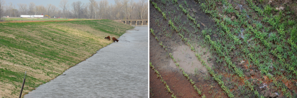
Levees function by an equilibrium of forces. They are usually earthen (made with tightly compacted soil), although many are augmented with concrete floodwalls or have entire sections made of concrete. Their shape is determined based on the most effective way to withstand the force of the water. An earthen levee tapers toward the top, creating a pyramid-like shape, which provides stability. Its base lies above a layer of very tightly compacted soil, which serves as a foundation between it and the ground below. If any part of the levee structure is compromised, the balance of forces can be upset.
All levees are continually battered by nature. The water side is scoured by river flows, waves, and eddies; collisions from boats, ice floes, and debris; and dredging. These impacts can erode the sides or bottom of the structure, sometimes causing part of the levee to collapse in a landslide. Earthquakes can cause cracks in levees or cause them to shift. Water seepage is a common problem that weakens levees and can result in breaches. Roots from vegetation, burrows dug by animals, grazing livestock, or drainage pipes that service roads built on top of a levee create piping, a form of internal erosion that allows water to seep into the sides. Piping in the foundation layer of soil can allow water to seep underneath the levee, which can allow it to be pushed laterally, or even tip over.

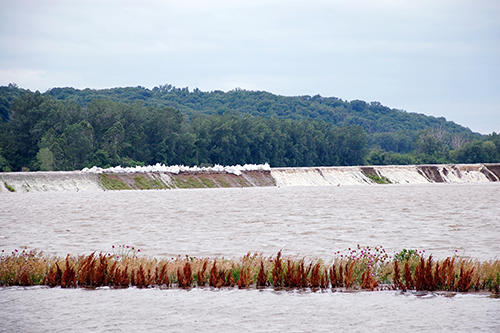
It is worth noting that despite their advanced age, the most common type of levee failure in the U.S. is overtopping. However, overtopping poses a greater risk than a breach due to the fact that it occurs during the heaviest floods, when the water level exceeds the levee height.
Overtopping is usually a result of increased development, rather than failure of the levee. As noted before, alterations to a river's course, along with sedimentation, increase the water level. This lowers the protection level of a levee: If it was designed 50 years ago to withstand a 100-year flood, it might be overtopped today by a less extreme flood. While many earthen levees have been enhanced with the addition of a concrete floodwall on top, adding to its height, these updates do not always keep pace with development of the surrounding land.
When a levee is overtopped, the water flowing over it may erode the levee. This not only lowers its height, allowing more water to flow over it, but also—unless the levee is constructed of erosion-resistant materials—the overtopping can weaken it, increasing the risk of a breach.
Accounting for Levee Failure in Flood Risk Management
The nation's riverine flood defenses protect millions of homes and millions of acres of farmland. About 80% of the Lower Mississippi River's floodplain, which contains about 1.5 million homes and thousands of agricultural buildings, is protected by some of the world's longest levee systems. Levee function, and the probability of failure, is an extremely important aspect of flood risk management in the U.S.; however, the design level of protection does not remain constant through time and is often open to misinterpretation. Levees are intended to reduce the risk of flooding, not eliminate it altogether. There is no such thing as a fail-safe levee.
Many organizations have started extensive projects to determine the state of repair of the country's levees. One of the most innovative of these is a joint effort undertaken by the California Department of Water Resources and NASA that uses remote sensing technology to locate tiny trouble spots in the Sacramento River delta levees. By locating areas of weakness still too small to be found visually, such as barely perceptible soil deformation, they hope to prevent future breaches that these weaknesses could lead to if left unattended.3
As local and federal officials work with many organizations to address the problem of the country's levees, their level of protection remains uncertain. The risk of failure at flood loads below the design protection level is a pressing concern. At the same time, levees have been known to withstand loads well above their design protection level.
Effective management of potential flood losses should therefore take into consideration the possibility of levee failure. It should be noted that FEMA's Flood Insurance Rate Maps, on which many private and governmental stakeholders still rely for flood risk management, are drawn based on the assumption that levees do not fail. A more realistic approach is the one taken by the AIR Inland Flood Model for the United States in which the failure of flood defenses is modeled probabilistically—using fragility curves that indicate the probability of failure given an intensity of loading. That is, although each flood defense is designed for a specific standard of protection (i.e., its design load), there is a non-zero probability that it will fail at load levels below that standard and a non-zero probability that the defense will hold for loads greater than the standard. Without proper treatment of the possibility of flood defense failure, modeled losses may not reflect the complete risk of flooding to exposures protected by levees.
1 Although this number includes coastal levees, the majority are riverine levees.
2 American Society of Civil Engineers, 2013 Report Card for America's Infrastructure
3 Rasmussen, C., NASA radar watches over California's aging levees, NASA/Jet Propulsion Laboratory, April, 2014
