


Note on Managing Earthquake Risk in Israel
May 27, 2014
Editor's Note: Ever since a series of five minor earthquakes struck northern Israel during one week in late October 2013, earthquake preparedness has been on the minds of many in Israel—including insurers. Although the largest of these October quakes was magnitude 3.5 (M3.5) and did not cause major damage, many wondered if this "earthquake swarm" was a portent of a larger quake in the near term. No one has the definitive answer, but insurers can understand their earthquake risk better through a comprehensive view of regional seismicity. This Note takes a brief look at the hazard.
Large earthquakes are rare in Israel, yet the country is located in a seismically active region, where many small earthquakes occur every year. The M7.1 Safed earthquake, which took place on January 1, 1837, currently remains the largest quake to strike Israel in recent history. Although there is uncertainty about the exact location, magnitude, and time of the next major earthquake that will strike Israel, disaster mitigation agencies, insurers and other risk managers, and government entities can prepare for and mitigate against a wide range of scenarios by using probabilistic modeling tools.
Israel's Tectonic Setting and Seismicity
Israel lies between the African and Arabian plates, whose movement away from each other is a major source of seismic activity from the Azores in the Atlantic Ocean all the way to the Hindu Kush in Afghanistan. The Arabian plate is moving north, away from the African plate, along the Dead Sea transform fault, which serves as a boundary between the plates (see Figure 1). Israel sits alongside this left-lateral strike-slip fault that extends 1,000 km (600 miles) from the Red Sea Rift and the Gulf of Aqaba in the south, across Israel, Jordan, Lebanon, and Syria, to southeastern Turkey.
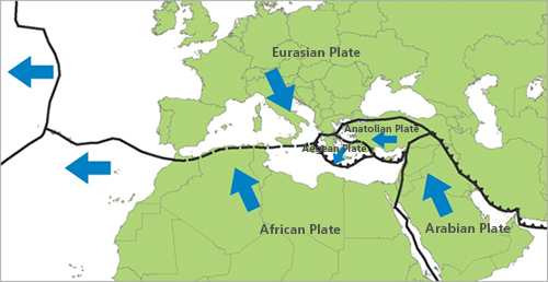
The epicenters of most earthquakes in Israel—including the Safed earthquake—are located either in or near the Jordan Rift Valley, through which the fault extends. The epicenter of the M7.1 1837 quake is believed to have occurred on a segment known as the Roum fault in the Jordan Rift Valley. The quake killed more than 5,000 people and caused massive damage in the cities of Safed and Tiberias. The city of Safed was almost destroyed, and almost every home in the nearby town of Jish was demolished. In addition, many towns and villages in the epicentral region were built on hilltops or steep slopes, and landslides were reported throughout the area. If the Safed earthquake were to recur today, AIR estimates that insurable losses would exceed EUR 3.3 billion based on the present-day building stock.
Is Israel Due for Another Big Quake?
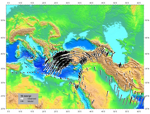
Because the scarcity of data on the historical occurrence of large earthquakes on this fault makes rupture probability assessments highly uncertain, seismologists use other tools—like regional and local GPS data and geological evidence from prehistoric earthquakes—to better understand long-term earthquake potential. AIR has developed a kinematic model that determines a continuous strain rate and velocity field across the entire plate boundary zone. Figure 2 shows that AIR's modeled velocity field matches the observed GPS and plate motion velocities quite well.
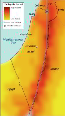
AIR scientists integrate the historical seismicity data, geological fault information, and geodetic GPS data to create a time-dependent view of regional seismicity. In time-dependent models of earthquake occurrence, the probability that an earthquake will occur in the coming year increases with the length of time elapsed since the last event. By taking into account soil and geologic conditions that affect how seismic waves propagate from the source of each simulated earthquake to each affected location, the seismic hazard map in Figure 3 shows calculated ground shaking intensities (expressed as peak ground acceleration) that have a 10% probability of being exceeded in Israel in the next 50 years (in other words, the 475-year return period hazard map). From Figure 2, it can be seen that most of Israel has moderate-to-high seismic hazard.
Preparing for the Future
Exposures have grown in Israel since the last devastating earthquake, and the potential exists for large losses, given both that the Dead Sea fault runs through the country and the high degree of industrialization that has taken place there during the last 60 years. A large earthquake occurring in northern Israel could potentially impact every major population center in the country, all of which are located within 71 km (44 miles) of the Dead Sea Rift.
Due to the low frequency of major earthquakes, traditional loss projection methods that rely on company claims data will not be a good predictor of possible losses. In addition, the constantly changing landscape of exposure limits the usefulness of past loss experience because new properties continue to be built in areas of high hazard, building materials and designs change, and new structures may be more or less vulnerable to catastrophe events than old ones. Catastrophe models can answer such questions as: For each potential event, what is the estimated range of damage and insured loss? What is the probability of a given level of loss for my portfolio in a wide range of catastrophe scenarios? Robust, fully probabilistic models capture potential losses before they occur to provide an objective and stable view of risk over time.
