


Shhh... The Quiet 2013 Atlantic Hurricane Season
Dec 19, 2013
Editor's Note: Forecast to be an above average year, the 2013 Atlantic hurricane season ended on December 1 as one of the least active on record by several measures. While named storm counts were higher than average, the number of hurricanes was far below normal levels, and no major hurricane formed. In this AIR Currents article, Tim Doggett, Senior Principal Scientist at AIR Worldwide, explores what happened this season.
Introduction
By June 2013, major forecasting agencies, including the National Oceanic and Atmospheric Administration and Colorado State University, had forecast an above average hurricane season in the North Atlantic basin. Six months later, the season ended as the first since 1982 with only two hurricanes, highlighting the level of uncertainty inherent in such forecasts. 2013 was also the first season in nearly 20 years without a major hurricane (Category 3 or higher on the Saffir-Simpson Scale).
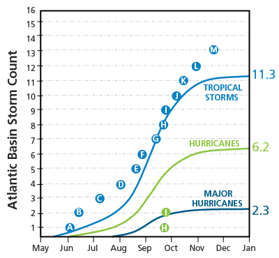
As seen in Figure 1, the counts of hurricanes and major hurricanes were significantly lower in 2013 than long-term climatological averages. The total Accumulated Cyclone Energy (ACE)—which represents the sum of the energy across all North Atlantic basin tropical cyclones during the season—was only one-third that of a normal season. Additionally, many of 2013's storms remained well out to sea and posed little threat to coastal locations. Hurricane Ingrid was the notable exception, making landfall along the northern Mexican coastline as a strong tropical storm before quickly dissipating as it moved inland.
 By: Tim Doggett, Ph.D.
Senior Principal Scientist
Edited by Eric Bland
The article: Reviews the 2013 Atlantic hurricane season.
Highlights: Despite predictions to the contrary, the 2013 season was one of the quietest in recent memory. Dry Saharan dust plumes, the timing of North American frontal systems, and other meteorological patterns inhibited storm development and helped make 2013 a very low loss year for Atlantic hurricanes.
The Start of the Season
The first named storm of the season, Andrea, formed on June 5 in the Gulf of Mexico. Andrea tracked northeast and brought tropical storm conditions to portions of Florida, Georgia, and South Carolina and caused minor damage. A few weeks later, Tropical Storm Barry produced moderate rainfall and flooding across portions of Central America and eastern Mexico, but only limited wind damage. In July, tropical storms Chantal and Dorian weakened into depressions before they affected land. Neither storm caused significant damage. In August, usually a month of increasing activity and, on average, the month most likely to see the first hurricane of the season, Tropical Storm Erin remained in the far eastern Atlantic, and Fernand maintained tropical storm status only briefly during its two-day lifespan in the southwestern Gulf of Mexico.
It's All Relative
September, as expected, was the most active month of the season, albeit with far less activity than usual. Wind shear inhibited the development of Tropical Storm Gabrielle, which formed early in the month. It tracked northward out of the Caribbean and dissipated north of Bermuda.
At about the same time, Ingrid formed in the western Caribbean and tracked across the Yucatan Peninsula and back into the Gulf of Mexico. It became the season's second and last hurricane on September 14, with a peak intensity of 85 mph. Ingrid made landfall in Tamaulipas, Mexico as a strong tropical storm on September 16. Wind damage was not significant, but the storm dropped heavy rainfall and caused serious flooding, the effects of which were amplified by the arrival of Hurricane Manuel from the East Pacific just two days later. Tropical Storm Jerry, which formed on the last day of the month, remained well out to sea.
A Quiet Conclusion to the Season
In October, Karen formed in the Gulf and tracked toward the southern U.S. coastline. The storm quickly intensified to reach peak winds of 65 mph on October 3, but strong wind shear and dry air weakened the storm's convection. Karen was downgraded to a tropical depression before it made landfall. Alabama, Louisiana, Mississippi, and Florida all issued states of emergency, but storm damage was minimal. Karen represented the only significant threat to the U.S. in 2013.
Tropical Storm Lorenzo battled strong wind shear to become the season's twelfth named storm in late October. Lorenzo stayed well out in the Atlantic and never intensified above marginal tropical storm intensity. The last storm of the 2013 season, Melissa, formed on November 20 and never approached land.
A Year for the Record Books
The 2013 hurricane season tied several records in the official HURDAT2 data set. The 2013 season is the first since 1982 with two or fewer hurricanes (prior to 1982, the last time only two hurricanes formed was in 1925—nearly 90 years ago). Hurricane extent (defined as the difference in days between the first and last hurricane reports in a season) was just six days (from September 11 to September 16), the shortest since 1925 (two days, August 20 to August 21). The season's first hurricane, Humberto, tied 2002's Hurricane Gustav for the latest date of formation (September 11) in the modern era of named storms, which began in 1950. On average, the first hurricane forms by August 10. The 2013 season is also only the fifth since 1950 with no major hurricane activity. The last time was in 1994.
What to Take Away from 2013
While climatic factors that are correlated with seasonal Atlantic basin activity led to expectations of an above average season, 2013 failed to meet preseason forecasts. This season is a good reminder that hurricane activity depends on a wide variety of environmental factors, many of which are unpredictable on all but the shortest of time frames. While the number of tropical storms was near normal, weather patterns, such as dry Saharan dust plumes moving over the Atlantic from West Africa, the timing of frontal systems coming across the northern United States, and periodic fluctuations in jet stream activity, influenced storm development, intensification, and track. While it is not possible to pinpoint a single reason for the inactive 2013 season, the combination of long-term climatic trends and shorter-term weather patterns over the Atlantic basin clearly dampened hurricane formation and activity.
