


Managing Storm Surge Risk in Great Britain: A Look Back at the North Sea Flood of 1953 and Xaver in 2013
Aug 05, 2019
Sixty-six years ago, a powerful storm in the North Sea sent waves crashing over coastal defenses in the UK and the Netherlands. Floods inundated thousands of square kilometers of land, damaging some 70,000 properties. More than 2,500 people lost their lives in the North Sea Flood of 1953, and it remains one of Europe's worst natural disasters in several centuries. Physical damage in the UK at the time was estimated at approximately GBP 50 million.
A confluence of many conditions made the storm and resulting surge especially powerful. But just how rare was it, and could a similar disaster occur today? While flood defenses and warning systems have improved dramatically since 1953, the population and exposure at risk have multiplied. Furthermore, the level of protection is not uniform along the vulnerable coast.
This article will take a look back at the 1953 floods, explain the factors that influence storm occurrence and storm surge potential, and examine coastal development and flood defenses before and after the event and the difference these make in terms of losses were a similar event to recur. Finally, we'll discuss how Storm Xaver (2013) illustrates the impact of improved coastal defenses and how the updated AIR Extratropical Cyclone Model for Europe, which includes a storm surge module that covers all of England and Wales, can help companies manage their UK storm surge risk.
The 1953 Event
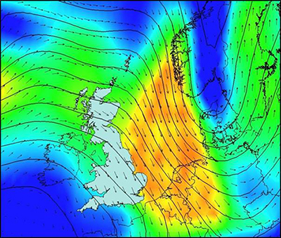
The North Sea Flood of 1953 was the result of several meteorological, oceanographic, and astronomical factors. From a meteorological perspective, the North Atlantic Oscillation (NAO) Index, which is well known to influence the tracks and intensities of storms that affect Europe, was highly positive. This positive NAO allowed the extratropical cyclone to form sufficiently far north to track over the British Isles before diving southeastward; it also created favorable atmospheric conditions for supplying energy to the storm.
The storm's formation over the central North Atlantic was unremarkable, but a set of conditions came together—including the phasing and super-positioning of an upper-level wave of low pressure and strong upper-level jets—that influenced its track and intensification. In fact, the cyclone underwent bombogenesis, a term reserved only for storms that intensify at the impressive rate of 24 mb or more in 24 hours. The cyclone deepened from 987 mb to 963 mb between 12:00 UTC January 30 and 12:00 UTC January 31. As a result, wind gusts in some locations exceeded 161 km/h (100 mph). In Costa Hill, Orkney, for example, a peak gust of 203 km/h (126 mph) was recorded.
 Richard M. Yablonsky, Ph.D.
Principal Scientist
 Austen Blair
Scientist II
Edited by Sara Gambrill, CEEM
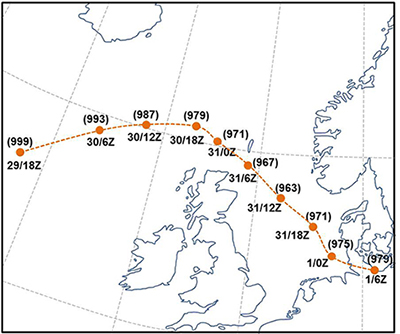
The narrowness of the upper-level wave drove the cyclone southeastward into the North Sea instead of eastward across it and helped elongate it in the north-south direction. These two characteristics resulted in strong northwesterly winds down a long fetch of the North Sea for a prolonged period of time.
From an oceanographic perspective, the storm surge and flooding in the Netherlands was the direct result of these northwesterly winds driving (dragging) water onshore near the time of high tide. Near where the center of the storm came ashore, the low pressure of the cyclone itself contributed almost a third of a meter to the storm surge. Maximum storm surge values exceeded 5 meters in the Netherlands.
Significant storm surge, exceeding 4.5 meters in places, occurred along the southeastern coast of the UK, even though winds were parallel to the coast. The nearly closed shape of the North Sea basin was one reason. Water that is dragged southward here will try to exit through the easiest opening it can—in this case the English Channel. As some of the water was redirected westward and pushed through this narrow channel, some of it piled up against the east coast of the UK as storm surge.
Furthermore, the Coriolis force, which results from the rotation of the earth, drives water at a 90° angle to the right of the direction of the wind (e.g., toward the west, for a south-moving storm) in a process known as Ekman transport. The Coriolis force may also have enhanced a feature known as a coastal Kelvin wave. This type of wave is long in wavelength and results in water piling up along right-hand side coasts in the Northern Hemisphere. (Both Ekman transport and coastal Kelvin waves contributed to the storm surge early on with Hurricane Ike in 2008; but these effects are even more significant at higher latitudes.)
Finally, from an astronomical perspective, the storm surge in many of the affected regions occurred around the time of high tide. This alone accounted for water heights of 2 to 3 meters above mean sea level in many places. Furthermore, it was not an ordinary high tide but rather a spring tide, occurring just after a full moon. This accounted for an additional meter of seawater rise.
The storm surge breached more than 1,000 flood defenses in England, and damage occurred along a 1,600-km stretch of the coast from Yorkshire to Kent. An estimated 24,000 homes were damaged.
A Brief History of Coastal Development
The east coast of England is no stranger to flooding from the sea. In medieval times, Anglo-Saxon settlers in this region built dirt embankments before reclaiming salt marshes and inland wetlands for farming purposes. Surviving evidence of these defenses can be found along the Lincolnshire coast, upon the Fens, and around the Thames Estuary in Essex and Kent.
It was only after the medieval period that it became standard practice to build flood defenses to protect existing settlements, and the development of land in coastal floodplains accelerated in the 19th and 20th centuries with the expansion of coastal towns and seaside resorts. Settlements that originated on relatively higher ground eventually spread into lower elevations to accommodate a growing population. This led to the building and strengthening of coastal defenses, which encouraged further expansion in low-lying areas.
One example of this tragic development cycle is Canvey Island in the Thames Estuary, situated below the mean level of high tides in the spring. The population of the island surged from about 300 at the turn of the 20th century to more than 11,000 in just 50 years. Canvey Island was one of the worst affected areas in the UK during the 1953 floods, when waters inundated the entire island.
London, too, has expanded throughout history with the reclamation of marshlands and the construction of increasingly sophisticated tidal defenses on the Thames Estuary, usually in response to flood events. The earliest recorded account of flooding along the Thames Estuary was in 1099, and later events were noted in London in 1236 and 1663. More recently, a storm surge in 1928 coinciding with high tide produced a peak height of 5.55 meters on the Thames in London. A large portion of the city was flooded and repairs took years to complete.
Flood Defense and Warning Systems
Since the flood in 1953 (and very much because of it), the UK government has devoted significant resources to improving coastal defenses. During the current program, which runs from 2015/16 to 2020/21, the Environment Agency will spend GBP 2.5 billion on flood protection (from rivers, the sea, groundwater, and surface water) in England.
The center of London was spared from major flooding in 1953, but the embankments along the Thames came dangerously close to being overtopped, which served as an urgent wake-up call that stronger defenses were needed to protect the capital. Legislation approving the construction of the Thames Barrier was enacted in 1972. The Barrier became operational in 1982, then was officially opened by Queen Elizabeth II in 1984. In addition, during construction of the Barrier flood defenses were raised by about 2 meters up to 30 km downstream to match the Barrier, and defenses up to 5 km upstream were raised to match the protection of Central London.
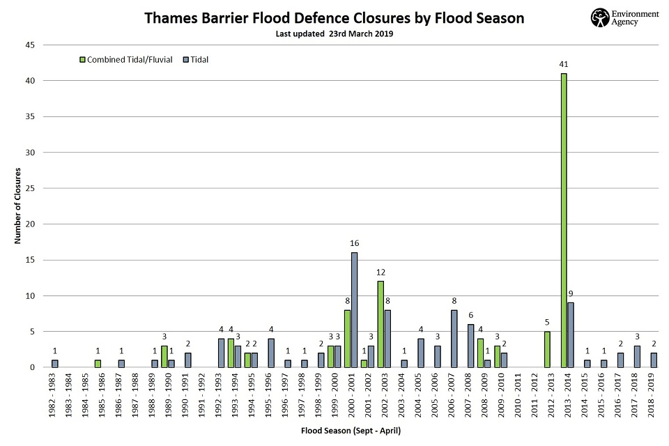
At the time it was built, it was estimated the Barrier would protect London from surge flooding until 2030, but a study published 10 years ago by the Environment Agency states that it could provide protection until 2070. While the Barrier was designed to protect London from storm surge, it is now being used to manage other types of flooding. Its gates have been closed a total of 184 times to protect against tide events, surge events, riverine flooding, and combinations of these. Before 2013, the Barrier was closed 124 times, but in the 2013 to 2014 flooding season (September to April) it was closed an unprecedented 50 times, the maximum number of annual closures possible to stay within the recommended number to avoid the risk of mechanical failure.
In addition to coastal defenses, the UK has also made significant improvements in forecasting and alert capabilities, the absence of which was a major reason why there was such a high loss of life in 1953. The Environment Agency uses information on potential tidal surges from weather satellites, oil rigs, weather ships, and coastal stations. They can forecast dangerous conditions up to 36 hours in advance and provide flood alerts to local authorities and directly to residents and business owners who sign up for an alert service.
ETC Xaver
The strong extratropical cyclone (ETC) known as Xaver came ashore on December 5, 2013, in Scotland with wind speeds comparable to those of a Category 1 hurricane. It then headed south and moved across the North Sea to the Netherlands, Denmark, and Germany. At the time of Xaver’s landfall, the Environment Agency (EA) warned of the most significant coastal tidal surge since the North Sea floods, and Xaver did bring record sea levels, which in places were higher than those seen in 1953.
Xaver was first recognized as a low pressure system off the coast of Greenland, developing into a powerful extratropical cyclone system as it passed north of Scotland on December 5. Exhibiting a period of very rapid strengthening known as “explosive cyclogenesis,” the system’s central pressure dropped from approximately 1010 millibars late on the 5th to a minimum pressure of 975 millibars 24 hours later. This rapid drop in pressure caused wind speeds to soar, reaching the maximum of “Force 12” on the Beaufort scale in some locations.
The UK experienced the brunt of Xaver. The storm’s surge caused a difference of 2 meters in water height between the front and back of the Thames Barrier, which was closed for two days to prevent the surge from reaching London.
The Impact of Improving Coastal Defenses
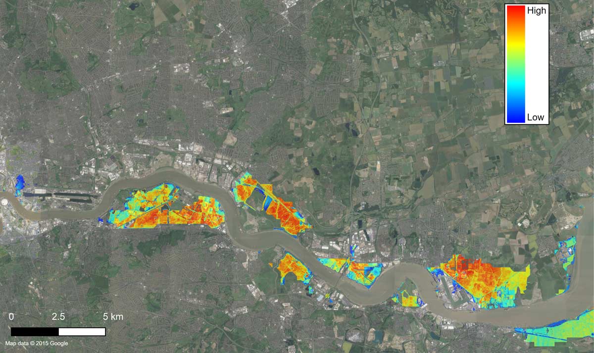
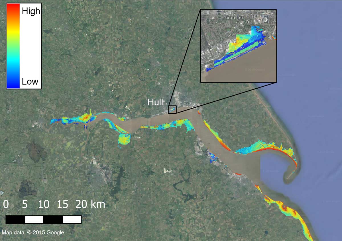
In the county of Yorkshire up the Humber Estuary lies the Kingston upon Hull (Hull), which was not well-protected from Storm Xaver’s storm surge. After Xaver, the UK expended a significant effort to fortify Hull from a future Xaver-like event. In all, according to the Environment Agency, more than 1,400 properties were damaged by flooding not only along the coast in Yorkshire but also in Lincolnshire and northeastern Wales by heavy precipitation that caused rivers to burst their banks. The Environment Agency also reported, however, that as many as 800,000 properties may have been protected by more than 2,800 km of flood defenses along the UK coastline. So while 1,400 properties were reported as flooded, it is clear that Xaver would have been a much larger catastrophe event for UK homeowner and commercial insurers and their reinsurers had the coastal and tidal river flood defenses not been so robust. The UK fortified the Thames River and London after the 1953 event to protect from the “next” 1953-like event, and Xaver in 2013 was a good test for these Thames Estuary defenses, which performed very well. Similarly, the UK fortified the Humber Estuary and Hull after Xaver to protect from the “next” Xaver; AIR’s new storm surge model, which incorporates these post-Xaver defenses, indicates that Hull should be well-protected from the “next” Xaver-like event.
Managing Storm Surge Risk in England and Wales
The 1953 event required many conditions to come together that—taken individually—were not unique. The wintertime NAO exhibits considerable variability on multiple time scales. For example, the NAO Index was positive a few days before the 1953 cyclone formed but dropped to near zero just two days later. And, from the 1970s through the 1990s, the NAO was positive in a vast majority of years during the winter. Since 2000, the split between NAO+ and NAO- years has been near even.
Storm tracks that carry cyclones down into the North Sea rather than across it are also not that unusual, occurring every 10 years or so. Oceanographic conditions, including the bathymetry and funnel shape of the North Sea, represent a fixed hazard. High tides occur twice a day and spring tides occur twice a month, at the time of new moon and full moon.
The updated AIR Extratropical Cyclone Model for Europe, which now includes a storm surge module that covers all of England and Wales, finds that loss-causing ETCs in England and Wales are a regular occurrence, about five or six per year, but the annual frequency of loss-causing coastal flood events is only two or three (though most of these are small and not memorable to insurers). While the North Sea Flood of 1953 is the most damaging storm surge for the UK in living memory, it should not be considered an exceedingly rare level of loss. In fact, more damaging scenarios are possible.
Future storms similar to the 1953 North Sea Flood and Xaver can occur, and they could be worse meteorologically, but the flood risk has been greatly reduced because of the modern-day levee infrastructure. To give our clients a comprehensive view of the risk, AIR’s new storm surge component for the Extratropical Cyclone Model for Europe includes a stochastic catalog of ETC events that could generate storm surge in England and Wales; probabilistic levee failure for each of the stochastic storm surge events; historical events, including two versions each of the 1953 North Sea Flood and Xaver, one of which has flood defenses at the time and the other of which has present-day flood defenses; and an extreme disaster scenario in which all flood defenses have been removed. The full range of scenarios a model can generate provide a unique and important perspective on an organization's risk. The careful analysis of model results can help risk managers prepare for many contingencies—thus ensuring that another North Sea Flood of 1953 or Xaver, for example, will not be entirely unexpected.
Ultimately, catastrophe models—such as the AIR Extratropical Cyclone Model for Europe, one of a suite of AIR models for Europe—help organizations evaluate the full range of potential events so that they can manage the risk effectively.
Resources
English Heritage (2011). Roman and Medieval Sea and River Flood Defences, Introductions to Heritage Assets
Hall, J.W., Sayers, P.B., Walkden, M. Panzeri, M. (2006). Impacts of climate change on coastal flood risk in England and Wales: 2030-2100, Phil. Trans. R. Soc. A, 364(1841), 1027-1049
Lavery, S., and Donovan, B. (2005). Flood risk management in the Thames Estuary: looking ahead 100 years. Phil. Trans. R. Soc. A, 363(1831), 1455-1474
Rijkswaterstaat and KNMI (1961). Verslag over de stormvloed van 1953 (Report on the 1953 Flood),'s-Gravenhage: Staatsdrukkerij en Uitgeverijbedrijf
Steers, J.A. (1953). The East Coast Floods, The Geographical Journal, 119(3), 280-295
Zong, Y. and Tooley, M. J. (2003). A historical record of coastal floods in Britain: frequencies and associated storm tracks, Natural Hazards., 29(1), 13-36
