


Modeling Fire Following Earthquake for the 2013 Japan Model Update
May 23, 2013
Editor's Note: Previous AIR Currents articles have given a broad overview of the upcoming release of the AIR Earthquake Model for Japan, an in-depth explanation of the seismicity changes made to the model, and a description of its new tsunami module. In this article, AIR Senior Scientist Erik Olson and Scientist Anna Morgante describe the substantial changes that have been made to the model's fire following earthquake component.
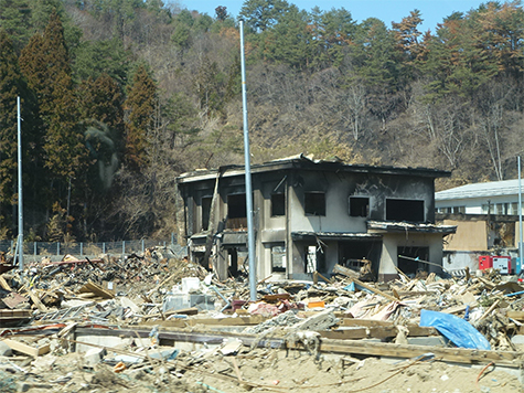
Fires caused by the Great Hanshin (Kobe) earthquake destroyed nearly 7,000 buildings in the Kobe region of Japan in January 1995. Before this earthquake, most "fire following earthquake" models were based on observations of fire spread behavior that were made in the first half of the 20th century. The Great Hanshin earthquake prompted a new wave of research, which in the past decade has led to the development of several advanced fire following earthquake models.
While fires caused by the 2011 Tohoku earthquake were less destructive than those in Kobe in 1995, they have served as a reminder of the continued threat of damage from this earthquake-associated peril. Also, fire ignition data from Tohoku has provided a new and important source of information that is helping researchers to better understand fire behavior.
The 2013 update to the AIR Earthquake Model for Japan includes a comprehensively updated fire following module that provides a considerably more detailed view of risk—throughout Japan—than did previous models. Enhancements include: substantially increased resolution; enhanced ignition modeling based on the latest research and data from historical events throughout Japan (including Tohoku); an innovative, cutting-edge approach to fire spread modeling; and a comprehensively updated "fire suppression" component.
 By: Erik Olson
Senior Scientist
 By: Anna Morgante
Scientist
Edited by Robert Zalisk
The article: Describes some of the cutting-edge advances in modeling fire following earthquake that have been incorporated into the AIR model update—including new findings from the Tohoku catastrophe.
Highlights: The new model features substantially increased model resolution and achieves more realistic results through detailed modeling of the built environment of Japan. And to simulate fire spread, AIR developed an innovative cellular automata model.
Improved Resolution: Capturing the Details
The degree of risk associated with fire following earthquakes is intrinsically linked to the characteristics of the buildings where fires might ignite and through which they can spread. To model fire following earthquake risk at high resolution, a detailed understanding of the layout and distribution of buildings throughout all of Japan is required. To accomplish this, AIR developed an innovative approach to modeling the spatial distribution of buildings. It is an approach that provides a significantly more detailed view of how buildings are arranged within blocks, from block to block, in cities or elsewhere.
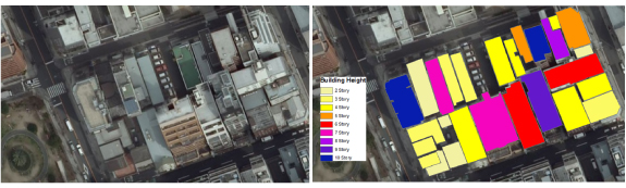
AIR scientists analyzed hundreds of city blocks throughout Japan and identified 20 representative block types from which the vast majority of observed building configurations can be constructed. AIR recreated the details of each block type digitally—and added an open-space block that contains no buildings at all but may represent possible parks, broad thoroughfares, open squares, etc.—to create a set of 21 "characteristic blocks." Figure 2 illustrates one step in the process, in this case identifying building footprints by height in one city block using satellite imagery.
This set of characteristic block configurations reflect building occupancies, heights and sizes, and layouts and is used in turn to construct the entire built environment of Japan. Land use and building density data at 1 km resolution are combined with the characteristic block parameters to produce a modeled distribution of 170 characteristic blocks of buildings or open space for every 1 km grid cell in the country. This approach to capturing building distributions at high resolution enables AIR to employ fire ignition and fire spread models at similar high resolution when estimating risk.
A New Approach to Ignition Modeling
The updated model applies the latest ignition rate research to historical ignition data and Japanese construction practices to create an ignition rate function that captures fire risk in Japan. The new ignition function is based on 1.0 second spectral acceleration (a measure of ground shaking correlated to building damage), which has been found to be more closely correlated with fire ignitions and building damage than peak ground acceleration, the variable traditionally used.
Another important consideration in ignition modeling is human activity and interactions with the surrounding environment. For example, research by the Tokyo Fire Department found that ignitions in Japan are correlated with seasonality, as more heating and lighting appliances are in use in winter than in summer. The 2013 AIR fire following earthquake module explicitly accounts for this seasonal variation in ignition rates.
A similar ignition phenomenon became apparent during the Tohoku earthquake. Fires can ignite hours or even days after the earthquake has struck, as electricity is gradually restored to damaged buildings. However, the immense scale of the Tohoku earthquake slowed the power restoration process for millions of customers throughout the affected region. This delay likely reduced fire ignitions, as it allowed more time for damaged buildings to be inspected and for hazardous situations (toppled appliances, frayed wiring, etc.) to be corrected. This understanding of the impact of power system infrastructure damage on ignitions from large earthquakes is also explicitly incorporated into the new AIR ignition model.
Innovative Approach to Modeling Fire Spread
Over the past decade, fire spread modeling has evolved from empirically based equations—which simulate a fire as a growing ellipse (as in the widely adopted Hamada model)—to cellular automata and physics-based models. These cutting-edge models explicitly take into account the dynamics of fire spread. To date, most of these models are applied only at the scale of a city or a section of a city because they are computationally intensive, requiring extremely high resolution building data.
However, using the latest research in the field, AIR scientists have developed a technique that simulates fire following risk countrywide. The technique makes use of a cellular automata model that can capture the detailed components of fire spread while remaining less computationally and data intensive than physics-based fire spread models.
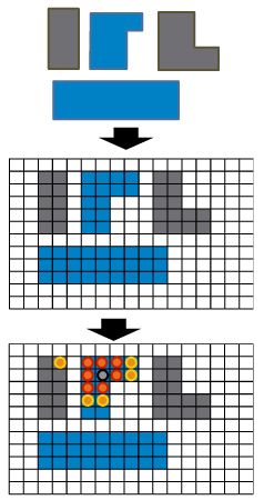
In this approach, a region is modeled as a uniform grid in which the grid cells are assigned properties that represent the underlying building information (combustible, noncombustible, etc.), as illustrated in a simplified schematic in Figure 3. The status of a fire—whether newly ignited or actively burning—is indicated in each cell, as shown in the bottom panel of Figure 3. Fire growth is simulated as the result of interaction between the cells, which is governed by a physically derived set of rules.
AIR's cellular automata model simulates fire spread on a grid consisting of 3 m x 3 m cells. The model is used to analyze fire spread risk within each of the 20 characteristic blocks comprising buildings (the one open block is assumed to hold no fire spread risk). In each case, the detailed building footprint and property information contained within a block were taken into account. The results of this analysis provided a detailed understanding of fire spread behavior for each of the building block types. In turn, these results are used to simulate the post-ignition growth of each modeled fire.
In addition to fire growth within a single city block, however, it is possible for fire to spread between blocks. In order to model potential block-to-block fire spread, the fire following module analyzes the probability of fires crossing a firebreak (for example, a street), which depends on the firebreak width (the distance from one building face to another building face, including the street width and the building setback distances) and wind speed and wind direction. The updated fire following earthquake module uses countrywide 1 km resolution street-width data for Japan to estimate firebreak widths within each grid cell. The use of 1 km resolution data explicitly takes into account the variation in firebreak widths within a city and differences between cities around the country.
Fire Suppression
Fire suppression is the one aspect of fire following earthquake modeling for which there has not been substantial new research since the release of the FEMA HAZUS model in 1997. The suppression component used in the earlier AIR fire following earthquake module, which takes into account fire engine and water availability, still represents the forefront of suppression modeling. All the same, several features of the suppression component were updated.
For one example, in the aftermath of the 1995 Great Hanshin earthquake, Japanese fire departments stepped up their preparedness for using alternative water resources (such as lakes and rivers) to suppress post-earthquake fires in the event that the primary water system failed. The new fire following module uses 100 m resolution land use data to identify the location of such alternative water sources and accounts for the possibility that these resources might be used for fire suppression.
Closing Comments
Every component of the AIR fire following earthquake module for Japan was updated for the 2013 model release. Fire following risk is now captured at a 1 km resolution that allows for a detailed understanding of both local and regional risk. The enhanced ignition model is based on historical events in Japan and provides an accurate view of the ignition potential for earthquakes occurring anywhere in the country. A new fire spread module combined with an advanced building distribution algorithm create a more realistic picture of fire spread behavior, while the modeling of fire suppression now includes the possibility of alternative water resources being used in suppression efforts. With these updates, the 2013 AIR fire following module for Japan achieves a more detailed and more accurate view of the risk associated with all identified impacts from fire following earthquake.
