


Introducing the AIR Inland Flood Model for the United States
Nov 21, 2013
Editor's Note: A previous AIRCurrents article explored emerging opportunities for private insurers in the U.S. flood insurance market. This article introduces the AIR Inland Flood Model for the United States, which will be released in the summer of 2014. With this release, AIR is providing insurers with the industry's most robust, fully probabilistic solution to manage a previously insufficiently understood risk.
The Risk of Inland Flooding in the United States
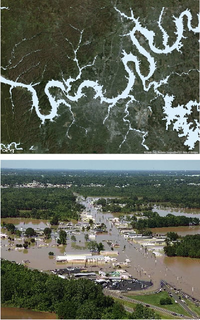
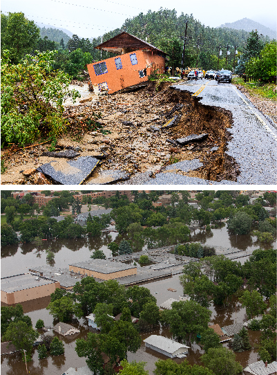
Riverine, or inland, flooding affects large regions across the United States. The country contains some of the world's longest river systems with enormous drainage areas, servicing a wide variety of residential, commercial, and industrial buildings as well as large industrial facilities. The watershed of the Mississippi River alone, one of the world's largest, comprises an area of 3.1 million km2 and covers just over 40% of the contiguous U.S. A major flood wave along the Mississippi, Missouri, or other major U.S. river can devastate the very areas that rely on that river for water, commercial and industrial use, and recreation. Even properties not situated on floodplains can be severely damaged, such as in June 2006, when flooding from intense rainfall affected parts of the greater Washington, D.C. metropolitan area.
Flood poses a continual threat across the entire United States. At any given time throughout the year, a potentially flood-producing storm is forming somewhere over the country, and the damage and loss can be devastating. As the population grows, so does development in flood-prone areas; often, development requires alterations to the river itself, affecting the water flow profile. As growth continues, so does the need for a comprehensive model that provides a robust view of the flood risk across the contiguous U.S.
 By: Dr. Boyko Dodov
Director of Flood Modeling
 By: Ann Weiner
Senior Science/Technical Writer
Edited by Nan Ma
AIR anticipates that inland flood models will soon become an essential part of catastrophe risk management, just as earthquake and hurricane models are today. With the regulatory changes that may be coming to the private market, insurers are facing increasing demand for comprehensive flood coverage. The AIR model provides an expedient solution, with the industry's most detailed and extensive view of flood risk for the contiguous U.S.
A Physically Based Probabilistic Approach to Flood Modeling
Inland floods occur for myriad reasons, and the circumstances that exacerbate or mitigate risk vary greatly. Evaluating flood risk is a complicated task, as the flood intensity at a given locality depends on many variables. Flood risk underwriting in the U.S. has thus far been unable to account for the many complexities that affect flood risk across a large and varied region. These include the continual changes in the characteristics of insured properties, such as new construction materials and building design practices, as well as the effects of infrequent flood events.
In 2014, AIR will introduce the industry's most detailed, physically based, probabilistic riverine flood model for the United States. The model makes full use of the recent availability of detailed terrain data and technological improvements in large-scale weather simulation, as well as recent advancements in computing power. It combines historical data with a robust atmospheric model, taking into account the effects of multiple weather systems, snowmelt, the presence of lakes and reservoirs, soil types, flood defenses, regional differences in building vulnerability, and other factors that contribute to flood losses.
A probabilistic approach is the only method that can account for all the complex variables associated with flood risk. It is also able to capture many sources of uncertainty, which are inherent in modeling any natural hazard and therefore extremely important to include when estimating property loss.
A Comprehensive Weather Model
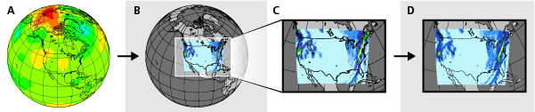
Of critical importance, when developing a comprehensive view of flood risk, is a rainfall simulation model that captures the frequency and severity of weather systems that can affect the modeled region. AIR has pioneered a dynamic rainfall simulation technique that captures large-scale systems while preserving fine-scale details, resulting in precipitation patterns that are realistic over space and time.
First introduced in the AIR Inland Flood Model for Germany,1 this approach seamlessly couples two well-established models developed by the National Center for Atmospheric Research (NCAR): a global atmospheric model (the Community Atmospheric Model or CAM) and a regional Numerical Weather Prediction (NWP) model (the Weather, Research, and Forecasting Model, or WRF).
An advanced stochastic downscaling technique applied to the WRF output yields robust and visually realistic precipitation patterns at a high-resolution (8 km grid).
Modeling Excess Runoff and River Discharge
The AIR model combines the precipitation patterns with the rate of snowmelt, which can contribute greatly to flood levels. To determine the amount of excess runoff over the ground, the model employs a hydrological model, which continually tracks the soil moisture near the surface. Surface river flows are based on the flow of excess runoff over land, and through streams. Using dynamic non-linear modeling of the ground's capacity to store water, the model estimates the baseflow—the flow that travels underneath the ground to enter a river. By combining the baseflow with the surface flow, the model is able to obtain the total river flow.
To realistically simulate the propagation of a flood wave along a river network, the model accounts for potential storms along with other factors, including the shape of rivers and the existence of levees, dams, or other structures. It computes the discharge at each location along the river network at given time intervals, producing a hydrograph that provides the flow along each river link. A flood routing system then obtains the discharge along the entire river network.
Determining Flood Intensity at a Locality
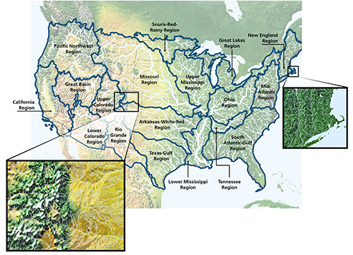
The flood intensity at a given location is determined in terms of the water's inundation depth. To calculate inundation depth at a high spatial resolution over the model's 2.2 million kilometers of river networks and 335,000 distinct drainage units, AIR uses an extensive set of geospatial information. This includes a high resolution digital terrain model from the U.S. Geological Survey (USGS), river networks, land use and land cover data, and local geological and soil conditions.
The river discharge data from the hydrological model is input to a physically-based hydraulic model to estimate flood extent and inundation depth. AIR has also developed a comprehensive set of 20 floodplain hazard maps that represent flood extents for return periods between two and 10,000 years. These maps provide extensive insight into the relationship between the discharge rate of specific rivers and the flood stage for different locations.
Flood Protection
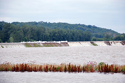
In many regions, flood risk is affected to a significant degree by the presence of levees, either man-made or natural (natural levees form from the deposit of sediments along the banks, creating a slope between the river and the adjacent land). Levee breaches can have a great effect on the dynamics of a flood wave as they allow a sudden burst of water that rapidly increases the volume and flow.
The contribution of levees is particularly apparent along the lower Mississippi River, where 83% of the drainage area is protected by levees. The AIR model incorporates extensive levee data covering over 22,500 km of rivers, from FEMA, the USGS, and the U.S. Army Corps of Engineers. In the event of a levee breach or overtopping, the model determines the damage using a dynamic method that determines the likelihood of failure as a function of peak flow.
Assessing Damage On and Off Floodplains
According to the USGS, there are currently about 3,800 U.S. cities and towns (those with a population of 2,500 or higher) that lie within floodplains. The area most prone to on-floodplain flooding is in the upper Midwest, within a region roughly outlined by the upper Mississippi River to the east and the Missouri River to the south and west. Here, precipitation from severe thunderstorms can combine with snowmelt, resulting in enormous floods along the northern Red River and many of the tributaries to the Missouri River
The risk of flood damage to property is, however, not restricted to floodplains, particularly as buildings in these areas are more likely to have flood-resistant construction, or flood defense systems. In towns and cities off floodplains, the ground may not be able to absorb persistent rainfall for a variety of reasons, including paving, poor drainage, or arid and relatively nonabsorbent soil and groundcover.
The AIR Inland Flood Model for the United States assesses on- and off-floodplain risk separately. Both methods use region-specific damage functions and capture the effects of regional construction practices on the building inventory.
Property Concerns Specific to Flood Risk
Damage estimation in the AIR model is based on an extensive analysis of regional design and construction practices, published research, damage surveys, and historical loss and claims data. The model considers the regulations that were in effect when a building was constructed, including requirements specified by FEMA's Flood Insurance Rate Maps (FIRM). Several important factors that affect the extent of property damage can be input into the model, including the elevation of the first floor, the year built, the foundation type, the presence of basements and flood defenses, and the floor level of contents.
The model also calculates time element damage, in order to take into consideration the extra costs associated with the time it takes to dry a building and return it to its full functionality. For commercial lines, time element loss estimates incorporate the effects of damage to supply lines, the feasibility of relocation and continued operations, and many other factors associated with business interruption.
Closing Thoughts
The upcoming AIR Inland Flood Model for the United States represents one of the most challenging and innovative research development efforts in AIR's history. This state-of-the-art model accounts for the unique circumstances that contribute to flood risk across the country. It provides insurers with a highly detailed, physically based, probabilistic approach for underwriting and managing this complex risk and for uncovering new opportunities in the evolving flood insurance market.
1 For a more detailed discussion of this approach, see the AIRCurrents article Innovation in Flood Modeling: Precipitating a Solution to Realistic Rainfall Simulation.
