


Insights into Damage and Vulnerability from AIR’s Sandy Survey Teams
Dec 20, 2012
Editor's Note: AIR dispatched three teams to survey damage in Rhode Island, Connecticut, New York, and New Jersey caused by Sandy. Team members included structural engineers Dr. Karthik Ramanathan, Matt Maddalo, and Aditya Kistemasetty; Matthew Holland and Nihal Joag from Consulting and Client Services; and Jared Seaquist from Business Development. In this article, Ramanathan, Maddalo, and Kistemasetty discuss the survey findings and how they inform AIR's understanding of damage and vulnerability in the areas impacted by Sandy.
Sandy was a post-tropical cyclone when it made landfall around 8:00 p.m. EDT on October 29, 2012, five miles southwest of Atlantic City, New Jersey. (For more on Sandy's meteorological evolution and insured loss estimates, please read the AIR Currents article The 2012 Hurricane Season in Perspective.) On November 6, AIR deployed our first damage survey team to South Kingstown and Westerly, Rhode Island, and New London, East Haven, and Niantic, Connecticut. The same team also surveyed damage the following day in Islip, Little East Neck, Massapequa, Long Beach, and Farmingdale, Long Island, New York.
On November 11, AIR deployed two more teams to Manhattan, Coney Island, Queens, and Staten Island, New York; and Atlantic City, Ocean City, Long Beach Island, Toms River, Point Pleasant Beach, Sea Bright, Keyport, Union Beach, Belmar, Keansburg, Secaucus, Moonachie, and Little Ferry, New Jersey.
The primary reason for AIR's reconnaissance was to study the effect of storm surge on engineered and non-engineered structures. In areas visited by AIR's survey teams, storm surge damage resulting from Sandy was much more severe than wind damage. In the Connecticut and Rhode Island areas surveyed, only structures on the immediate coast were severely damaged by surge. In Long Island where surge heights were higher, some entire neighborhoods were inundated with surge waters. In these areas, a significant number of properties even several blocks from the coast showed signs of building and contents damage. Cars, pleasure boats, and other heavy objects were displaced.
In coastal areas of New York and New Jersey, the majority of the damage was due to storm surge; in inland areas, there was damage caused by riverine flooding, wind, and tree fall. The coastal communities of New Jersey surveyed experienced extensive to—in some cases—virtually complete damage due to storm surge.
What follows is a detailed look into the type of damage caused by Sandy and the vulnerability of residential, commercial, and industrial exposures the storm revealed in areas surveyed by the AIR teams.

By: Karthik Ramanathan, Matt Maddalo, and Aditya Kistemasetty
Edited by Sara Gambrill
Wind Damage Consistent Across a Broad Footprint
Not surprisingly, AIR survey teams found that wind damage was generally higher along the coast where stronger winds were observed. AIR also surveyed inland locations where wind measurements were available. AIR's damage surveys yielded fairly consistent results across the area affected by the storm. The mechanisms of damage observed were in line with AIR engineer expectations for an event of Sandy's sustained wind speeds, which ranged between 40 and 50 mph over the wide event footprint.
In general, wind damage was typically limited to the building envelope: roof covering, flashing, and wall siding (see Figure 1). At inland locations where sustained winds of weak tropical storm strength were recorded, an estimated 2% to 5% of homes experienced wind damage. It was unclear how many windows had been protected during the storm, but winds were probably not strong enough to make debris a significant source of opening damage. Damage to garage doors, typically one of the weaker components in a residential structure, was driven by surge rather than wind.
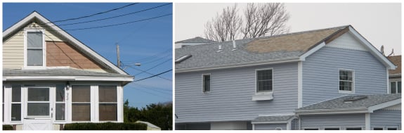
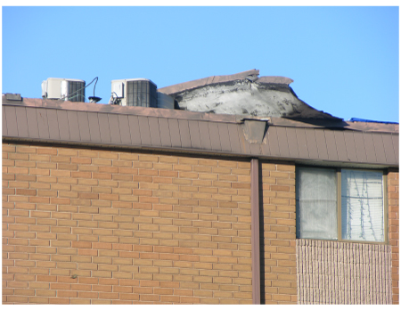
Commercial wind damage was less common than residential wind damage, as one might expect (although it should be noted that high-rise rooftops were out of view of our survey teams, who were on foot). In Connecticut and Rhode Island, smaller commercial or hotel structures with similar components to residential homes (shingle roofs, vinyl siding, etc.) experienced similar moderate damage in some cases. Larger, engineered commercial properties in these areas, however, were left mostly unscathed. An apartment building near East Haven, Connecticut, was a rare exception, though the structure's flat roof shape, height, and rooftop equipment may have contributed to its vulnerability (see Figure 2).
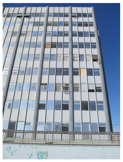
But, in locations very close to Sandy's landfall, such as Atlantic City, New Jersey, there was evidence of wind damage to large commercial structures (see Figure 3). For high-rise hotels and casinos in the area, observed damage took the form of blown-out windows or missing signage, consistent with expectations for commercial engineered buildings in a low wind event. While damage to signage is merely cosmetic, more moderate damage to window openings and cladding can result in contents damage from wind-driven rain.
In the rare cases where more severe wind damage was seen, it was nearly always caused by a downed tree or utility pole.
Residential Storm Surge Damage—A Coastal Issue
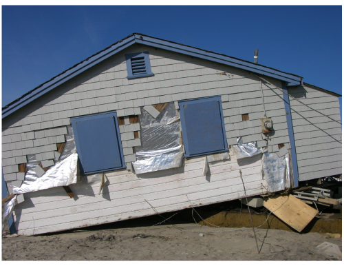
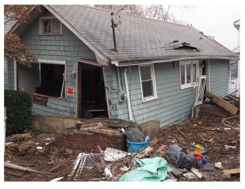
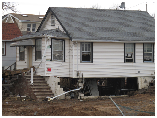
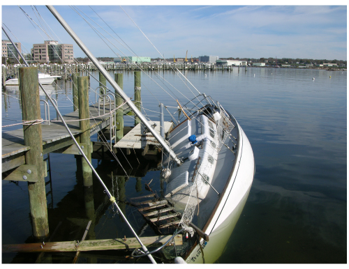
The nature of damage due to storm surge and wind differs substantially, and location plays an important role in determining which sub-peril is the source of damage. Surge damage is typically localized near the coast. The AIR teams found houses located right on the coast that suffered heavy damage (see Figure 4), while some located just one block inland fared much better.
The extent of storm surge damage along the coastline stretching from South Kingstown, Rhode Island, to Ocean City, New Jersey, was significant. For example, more than 95% of the residential structures in the neighborhoods of Rockaway, Queens, and New Dorp Beach and Midland Beach, Staten Island in New York as well as Keyport and Union Beach, New Jersey were either yellow tagged or red tagged by city inspectors. A yellow tag means that parts of the building are structurally safe while other parts are not safe. A red tag means that the building is structurally unsafe, and no one should enter it (see Figure 5). Vulnerability of residential buildings to storm surge was found to be influenced by construction type; first floor elevation; presence or absence of a basement; and non-engineered components such as garage doors and main doors.
The effect of storm surge was particularly devastating for light-framed wood and unreinforced masonry residential structures (see Figure 5). In contrast, reinforced masonry and concrete frames structures were able to survive substantial surge inundation with minimal damage.
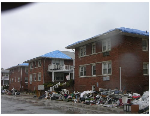
In many cases, even if the building structural envelope remains intact, internal building components such as flooring, wall plastering, ceiling, etc. may need to be replaced, and damage to contents can be significant. The survey teams noted discarded contents along the streets up to a few blocks inland in almost every neighborhood surveyed in New Jersey and New York (see Figure 6).
Storm Surge's Effects by Building Elevation and Foundation Type
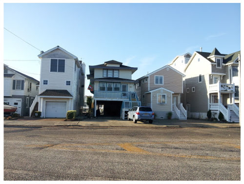
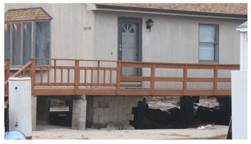
Building elevation and foundation type were critical determinants of storm surge damage. Buildings with an elevated first floor performed better than buildings whose first floor was at street level. For example, on a street in Ocean City, New Jersey, seen in Figure 7, where a four-foot storm surge was measured, a house built on stilts (second from the left) above the required base flood elevation (BFE) experienced only minimal damage. The residents of the other three houses shown in Figure 7 reported that they had extensive damage, which resulted from: a garage on the first floor (left); a basement under the BFE (third from the left), against FEMA guidelines; and closed foundation walls (right).
Houses that were not elevated typically had a slab foundation or a shallow spread foundation in the areas surveyed, and these experienced extensive damage in all coastal communities surveyed in New York and New Jersey (see Figure 8, left). Spread footings performed better in many cases than their slab counterparts. Complete failures of elevated houses founded on different footing types were commonly seen in communities along the coast in New York and New Jersey.
In addition, some elevated houses suffered significant damage attributable to the foundation system underneath. Residential properties with closed foundations—such as center-block and perimeter wall systems—were prevalent in the area and experienced extensive damage (see Figure 9, and Figure 10).
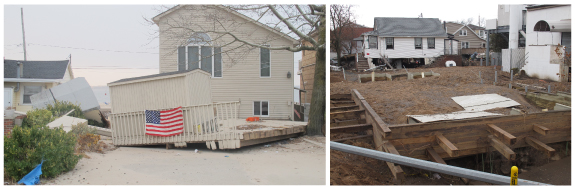
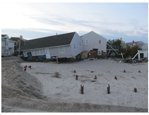
Open foundation types—such as driven piles and short wooden columns—were also prevalent in the areas surveyed. Houses built on open foundations where the ground floor slab was resting on too short wooden columns were often subject to uplift and subsequent dislocation and collapse due to storm surge. In many coastal communities, the only remaining evidence of residential construction was the presence of the foundation or ground floor slab on grade and a considerable pile of debris at street level (see Figure 8b and Figure 11).
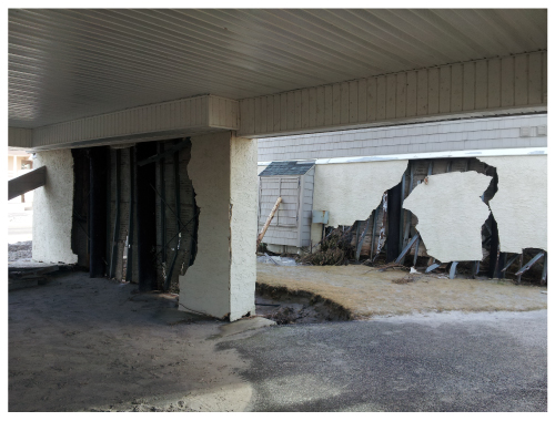
Façade walls and garage doors in houses could also be subjected to severe damage or collapse if they experience high-velocity storm surge. This, too, was observed in many coastal communities in New York and New Jersey (see Figure 12).
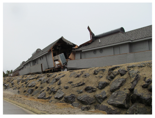
Storm surge proved catastrophic for some of the long and slender buildings along the coastline. Several of these buildings that are parallel to the coast were split in half (see Figure 13). According to Federal Emergency Management Agency (FEMA) guidelines for buildings in Zone V, the longest horizontal structural member should be oriented perpendicular to the coast. Atlantic City and Ocean City, New Jersey, fall into the high risk FEMA zones AE and VE. Much of the observed damage in this region was to homes—even new ones—not built to FEMA guidelines.
Basements and Appurtenant Structures
The presence of a basement exacerbates the level of damage to contents and building including floors, interior walls and finishes. Consistent with this fact, extensive damage to residential structures with basements was seen in the areas surveyed. According to FEMA guidelines, crawl spaces are not permitted in high risk coastal area (Zone V) construction, and open pile or column foundations that can withstand storm surge and wave forces are required. Portions of buildings built in Zone V below the BFE must be constructed with materials resistant to flood damage. Any building utility systems within the crawl space must be elevated above BFE or designed so that floodwaters cannot enter or accumulate within the system components during flood conditions.
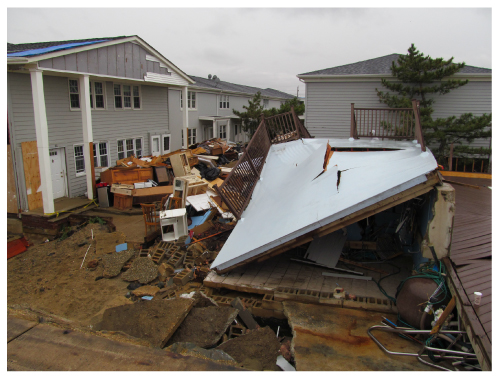
In addition to the main residential structure, widespread damage to appurtenant structures was observed in most areas surveyed in New York and New Jersey (see Figure 14).
Contamination
Another impact of Sandy was widespread pollution caused by floodwaters carrying a variety of toxic chemicals, petroleum, and fluids from cars and boats. In addition, floodwaters in Manhattan carried contaminants from inundated subways and tunnels, roads and parking lots, and floodwaters in industrial areas, such as Kearny and Secaucus, New Jersey, carried contaminants washed from shoreline industrial sites as well as commercial and residential buildings. These hazardous floodwaters, combined with sewage overflows, led to contamination in several neighborhoods along the coast.
Commercial and Industrial Structures and Business Interruption
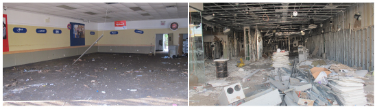
Sandy unleashed its fury on the dense commercial areas of Manhattan and Atlantic City, leading to significant building and contents damage, which in turn led to downtime. Although they did not sustain as many cases of structural and building envelope failure as residential construction did, commercial structures still sustained significant surge damage to interior building elements such as partition walls, floors, finishes, etc., which will need to be replaced. Damage to contents and downtime associated with the occupancy and normal functioning of the buildings represent a significant chunk of the losses associated with commercial and industrial structures (see Figure 15).
Small commercial buildings, including restaurants and grocery stores, in the neighborhoods of Battery Park, Greenwich Village, the Meatpacking District, and the Lower East Side of Manhattan close to FDR Drive, suffered significant building, contents damage and downtime due to storm surge inundation. For example, more than 90% of the small commercial buildings in the Battery Park neighborhood were either yellow tagged or red tagged.
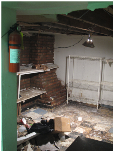
Small commercial buildings in the Lower Manhattan neighborhoods surveyed typically had basements for storage, and the presence of a basement exacerbated the amount of damage and downtime. Contents such as compressors, refrigerators, dry food, and HVAC equipment had to be discarded due to flooding and loss of power. Significant building damage was also associated with the need to replace floors, partition walls, and basement roofs due to the ingress of moisture and water-related damage (see Figure 16). Conversations with restaurant and grocery shop owners revealed that the majority of them did not possess flood insurance.
Retail stores, most of which did not have basements, also experienced major damage to both building and contents from the impact of storm surge.
Many of the high-rise commercial structures along Whitehall, Water, and Pearl streets in the Battery Park neighborhood of Lower Manhattan and on the boardwalk in Atlantic City, New Jersey, were surveyed. The flooding of underground parking structures, elevator equipment rooms, and server rooms, led to the shutdown of these facilities. It is not clear from these surveys if the associated downtime is covered by insurance. The AIR team visited the area two weeks after Sandy made landfall and power and heat had yet to be restored to these buildings.
Amusement parks in Coney Island, New York, and Sea Bright, Seaside Heights, Atlantic City, and Keansburg, New Jersey, also suffered massive damage and will need to be reconstructed before they can be opened to the public.
An industrial area in Kearny, New Jersey, was subject to significant flooding due to the overflowing of the Hackensack and Passaic rivers. No storm protection system was in place, which is typical in this area. According to personnel at a large oil and natural gas storage facility off Doremus Avenue in Kearny, New Jersey, the entire area experienced approximately two feet of flooding. It is believed that some of the large oil and gas storage tanks shifted from their locations due to the heavy currents in the oncoming flow. The facility was out of business for two weeks, which was partially responsible for the gas shortage in the area. Hurricane and storm surge risk reduction systems or simply storm defense mechanisms can play an important role in mitigating the entry of storm surge into neighborhoods and therefore reduce building, content, and downtime losses; their effectiveness depends on the quality of construction and—to a greater extent—on the design level of storm surge, as AIR observed in the industrial and residential neighborhoods surveyed in New Jersey.
Other LOBs: Automobiles, Pleasure Craft, and Builder's Risk
Aside from residential and commercial buildings, many additional types of exposures were affected by Sandy. In nearly all of the surge-affected areas surveyed, significant numbers of damaged cars were observed (see Figure 17, left). In Manhattan, underground garages contained many vehicles that showed signs of having been submerged and are likely total losses (see Figure 17, right).

Pleasure boats were also a part of Sandy's devastation. Multiple damage mechanisms for boats were seen in New London, Connecticut, and Keyport and Long Beach Island, New Jersey. There were cases of boats that had been beached after breaking loose from their moorings, as well as crafts that had sunk after being battered against their own docks (see Figure 18).
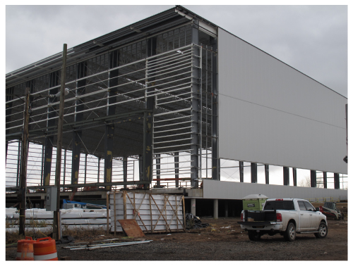
AIR survey teams also observed damage at in-progress construction sites, which would likely be covered under Builder's Risk insurance policies. At a Staten Island athletic facility under construction, walls were not yet completed, so the structure was not fully enclosed. It is often the case that a building is most vulnerable to wind during this construction phase. Winds were able to enter the footprint of the building and tear siding off the back of the structure (see Figure 19). AIR engineers also spoke to construction workers in Manhattan who had to pump several hundred million gallons of water out of a foundation work site. These cases highlight the ways in which builder's risk vulnerability depends on both construction phase and the peril in question. While strong winds may pose little threat to a recently poured foundation structure, storm surge inundation can result in significant damage or project delays.
Closing Thoughts
Ultimately, AIR's damage survey findings revealed the vulnerability of many types of exposures to storm surge along the coast of the Northeast U.S., from the densely populated urban neighborhoods of Manhattan to the coastal communities of New Jersey, Long Island, Staten Island, Connecticut, and Rhode Island. Numerous insights were gained from this event that aid in the identification of structural attributes that contribute to damage and ensuing loss—building, content, and downtime alike—for residential, commercial, and industrial lines of business as well as specialty lines, such as pleasure boats and builder's risk.
These insights not only facilitate an enhanced understanding of inherent vulnerability but also help us formulate better damage functions that capture these attributes. The teams' findings underscore the importance of having detailed location-level data for modeling, such as: distance from the coast; if on the coast, type of footing or foundation; compliance with FEMA guidelines for recommended construction practices and elevation above the base flood elevation as dictated by the flood insurance rate maps. Having this type of detailed data will go a long way in helping companies assess the risk to their coastal exposures.
