


Take the 2020 U.S. Hurricane and Flood Season by Storm
Completing Your View of Risk with Hurricane-Induced Precipitation
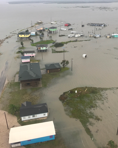
The 2017 and 2018 Atlantic hurricane seasons set records for precipitation and left lasting impacts from the severe flooding brought on by intense storms. In August 2017 Hurricane Harvey flooded Texas with record-breaking rainfall, and in September 2018 Hurricane Florence brought severe flooding to the Carolinas. By leveraging the innovative methodologies we developed and employed in our Japan inland flood model and advanced machine learning techniques, we updated the AIR Hurricane Model for the United States to include the explicit and probabilistic modeling of precipitation-induced flooding associated with hurricanes.
Capturing a Unified View of Flood Risk On and Off the Floodplains
Both Harvey and Florence are well-known events that brought record amounts of pluvial flooding, devastating homeowners, many of whom were located outside the NFIP’s X and A flood zones. AIR models both on- and off-plain flooding, producing a more continuous view of spatial flood risk. A granular view of drainage capacity in urban areas and an accurate depiction of flood risk from surface flooding provide users with spatially discrete estimates of flood risk everywhere within the model domain—including areas not yet mapped by FEMA.
Leverage AIR’s Unified Flood Vulnerability Framework Across Both U.S. Models
The U.S. hurricane and flood models employ the same, component-level vulnerability framework to quantify losses from inland flooding and hurricane precipitation events. The same primary and secondary risk features are available and applied for both of the models. In the case that information about secondary features are not available, AIR offers the first market-wide solution to account for community-level flood regulations, including reliable first-floor height assumptions. In addition, the framework explicitly models large industrial facilities, accounting for different types of mitigation features, and other specialty lines.

Own Your U.S. Flood Risk With These Complementary Solutions
When the AIR Hurricane Model for the U.S. and the AIR Inland Flood Model for the U.S. are used in in combination, they provide one unified view of precipitation hazard, just as it would be observed in nature, for a comprehensive view of flood risk. Our risk management platform breaks out the potential losses by different peril types, so it is easy to evaluate the total flood risk of an exposure. Using peril coding and analysis settings, both the hurricane model and the inland flood model can be run to include only the losses associated with flooding to help you manage all of your flood risk.
