


The last update to the National Seismic Hazard Model (NSHM) for New Zealand was a minor tweak to the 2002 version in 2010. A working group led by Geological and Nuclear Sciences of New Zealand (GNS) is working on a new update due to be released in August 2022 (NSHM2022); significant changes to hazard estimates due to science and end users’ needs are expected. Key priorities among those set for updating the science and model outputs include:
- Development of a homogenized (moment magnitude) historical earthquake catalog
- Combining information from the earthquake catalog, geodetic strain rates, and earthquake geology (faults) to develop a hybrid gridded seismicity model (areal source)
- Application of the UCERF3 grand inversion recipe to model complex multi-fault/segment ruptures, including information from both geological (fault) data and geodetic data (geodetic deformation model)
- Consideration of temporal variability in seismicity and development of a hazard model that may be valid for the short term
- Regionalization of the ground motion model and modeling local basin effects
The AIR Earthquake Model for New Zealand was updated in 2019 using the 2010 NSHM as the reference model but with many new insights and deviations from it. It was updated in consultation with local scientists from GNS and the University of Otago to ensure that the latest scientific data were incorporated and in anticipation of the next version of NSHM. The AIR model also reflects international best practices in seismic hazard and risk modeling and learnings from the 2010/2011 Canterbury Earthquake Sequence and the 2016 Kaikōura earthquake. As a result, the AIR model addresses most of the issues in the 2010 NSHM that are likely to be addressed by the NSHM2022. Table 1 lists some of the changes expected for NSHM2022 based on a presentation given by the National Seismic Hazard Model Revision project in November 2020.
| Previous Models | 2022 Update | Expected Impact | AIR Model |
|---|---|---|---|
| Single model of fault slip rates, little geodetic data | Multiple models from geology and geodesy | Larger range of earthquake rates considered | Considers both geological slip rate and deformation models from geodetic data |
| A fault segment producing one magnitude only | A fault produces multiple magnitudes (considers magnitude uncertainty) | Larger range of earthquake rates considered | Considers magnitude uncertainty in characteristic earthquake magnitude for all fault sources, allowing magnitude variation up to ± 0.48 magnitude unit |
| Single fault rupture, some limited multiple-fault rupture through simplification | Systematic complex multi-fault interaction (UCERF3 type recipe) | Realistic ruptures; possible increase in very low probability hazard and decrease in higher probability hazard | Implements a limited set of UCERF3 types of multi-fault rupture by grouping crustal faults into 4 groups; includes larger, longer earthquake ruptures |
| Few large, high magnitude earthquakes | Allowance for potential large ruptures at low rate | Realistic ruptures; possible increase in very low probability hazard and decrease in higher probability hazard | Increased upper bound magnitude for both crustal and subduction zone earthquakes; includes megathrust earthquakes |
| Simple planner geometry | More accurate geometry, much less restricted scenarios | More accurate hazard calculation | Uses dense grid mesh to capture complex fault geometry for accurate ground motion calculation |
| Single model for earthquakes on unknown faults, no uncertainty | Multiple models, constrained by different data and hypotheses | Larger range of shaking considered, some hazard increase, not yet fully understood | AIR’s background seismicity model based on primarily historical data |
| Historical catalog not homogenized | Homogenized moment magnitude catalog | Impact unknown | AIR researchers developed regression equations for magnitude homogenization and a homogenized historical catalog |
| Ground motion model: single ground motion prediction equation for each event type | Multiple GMPEs will be considered as part of epistemic uncertainty | Impact varies depending on type of event, ground motion period, and site location | Includes GMPEs developed in other similar regions for epistemic uncertainty consideration; all GMPEs have been evaluated against New Zealand strong motion data to create a regionalized ground motion model |
| Ground motion model: no basin effects due to limitation of GMPEs | Will consider basin and path effects | Increase long period ground motion hazard in basins | Site effects and basin effects are considered through GMPEs |
Homogenized Moment Magnitude and Epistemic Uncertainty
In addition to incorporating new science, NSHM2022 will address some of the shortcomings in the current seismic hazard model. No magnitude homogenization was done for the 2002 and 2010 NSHMs, for example, and this could become an issue when considering ground motion prediction equations developed outside New Zealand, which typically use moment magnitude. Both the 2002 and 2021 NSHMs used a single ground motion prediction equation (McVerry et al. 2000 for the 2002 NSHM, and McVerry et al., 2006 for the 2010 NSHM) developed locally for New Zealand. No epistemic uncertainty for ground motion is considered in the calculation of hazard. Similarly, for the seismicity model on fault sources, no epistemic uncertainty is considered in characteristic earthquake magnitude for individual faults or fault segments.
Hybrid Gridded Seismicity Model
One of the principal changes in the update is that NSHM2022 will use strain rates and deformation rates obtained from the geodetic model in constraining seismicity as an alternative model. In particular, it intends to use two types of geodetic models: one is the strain rate or deformation rate model obtained from kinematic modeling of GPS data; the other is the deficit slip rate model on faults from a block model of GPS data.
The deformation rate model and deficit slip rate model will both be applied to seismicity modeling on fault sources. The strain rate model may be applied to the gridded seismicity model. Which deformation models will be used and how they will be used in NSHM2022 have yet to be determined. The deformation rate model from the kinematic modeling of GPS data (e.g., Beavan & Haines, 2000) is used to constrain the rate of larger magnitude earthquakes in various source zones. The AIR Earthquake Model for New Zealand has already incorporated the latest deformation models in constraining crustal seismicity.
The importance and impact on hazard of using the geodetic model in seismic hazard analysis has been discussed in detail in this AIR Current: Modeling Fundamentals: Understanding Tectonic Movement and How It Sheds Light on Seismic Risk. The deficit slip model of Wallace et al. (2012) is used to constrain the seismicity rate and rupture probability of earthquakes along different parts of the Hikurangi subduction zone, as well as the kinematics of the tsunami rupture model in the AIR model.
The use of the strain rate model to provide a short-term view of background seismicity is still new and exploratory. New Zealand scientists have been studying the statistical correlation between deformation rates and historical seismicity to justify applying this approach to the hazard model. The result, reported in the April 2021 Annual Meeting of the Seismological Society of America, does not seem to be very conclusive, but the study is still in progress.
A More Complex, Multi-Fault Model
NSHM2022 will use the UCERF3 grand inversion recipe to develop a more complex, multi-fault model for New Zealand. The fault database in New Zealand has more faults than the database for California, where the UCERF3 model was developed and applied. This would significantly increase the computation time for the grand inversion, as AIR discovered when applying the UCERF3 model to New Zealand faults in the development of our New Zealand earthquake model.
The proximity of the subduction zone with crustal faults also complicates the computation due to potential interaction between subduction zone ruptures and crustal ruptures. Therefore, GNS scientists will balance the computation cost with model complexity to develop a practical fault rupture model.
AIR scientists noticed a similar challenge when developing a multi-fault model for New Zealand. To overcome the challenges in computational time and model complexity, AIR divided the entire fault database into four groups and developed a limited set of multi-fault rupture scenarios for each. This greatly reduced computation time while capturing the important elements for the fault model, such as inclusion of large magnitude, long rupture, and high impact events.
NSHM2022 will include an updated community fault model (CFM). Currently the working group plans to use Litchfield et al. (2014)’s fault model, expanded to include information published since 2014. The AIR Earthquake Model for New Zealand also used Litchfield et al. (2014) fault data as the primary source.
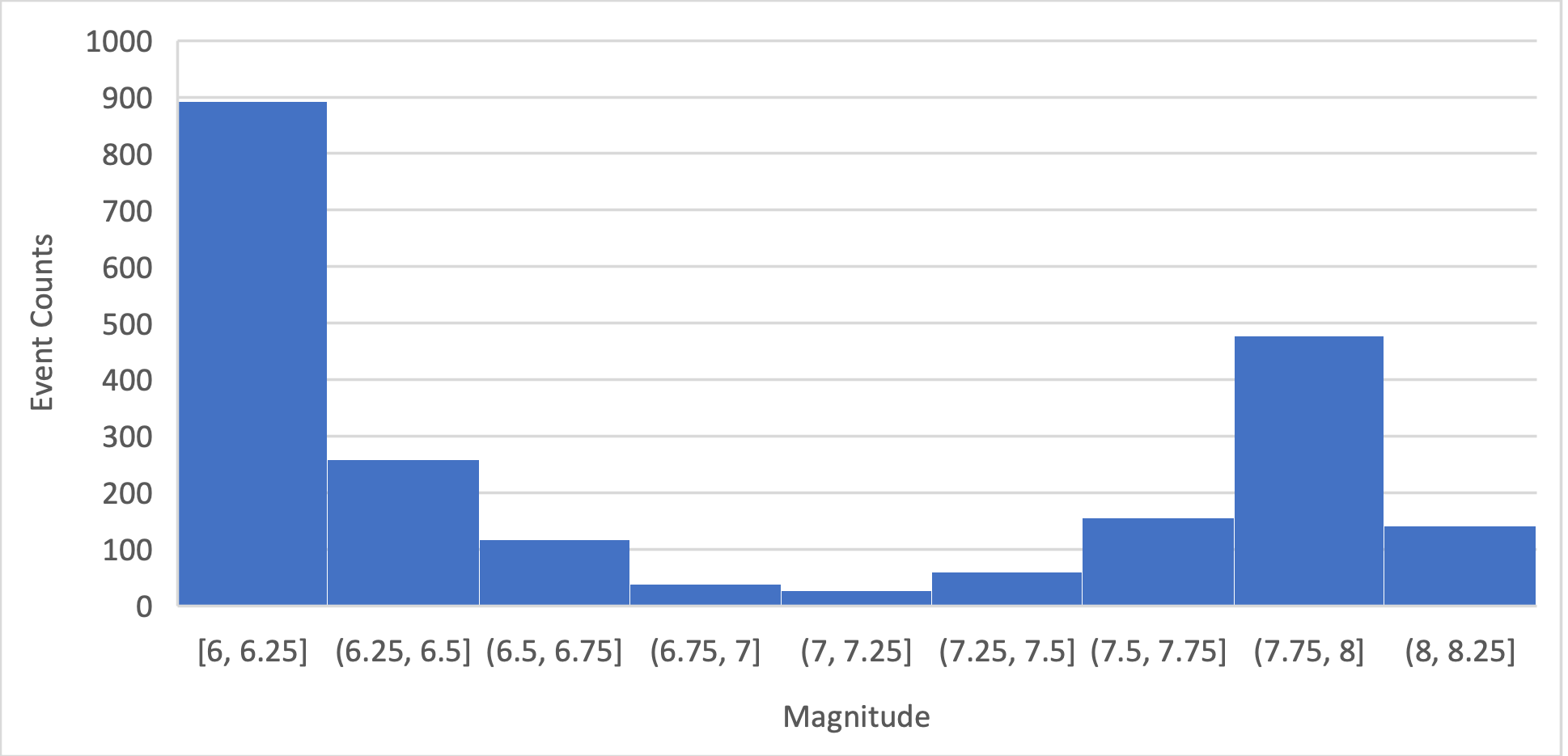
Howarth et al. (2021) recently developed a fault rupture model for the Alpine Fault based on detailed paleoseismological data from lake deposits along the Alpine Fault and physically based simulation (Howarth2021 hereafter). Their research concludes that the Alpine Fault (the Central and South Westland segments) has a 75% rupture probability in the next 50 years. Based on their simulation (their preferred model), the magnitude of earthquake has a strong bimodal distribution peaking at the magnitudes of 6.0-6.25 and 7.75-8.0 (Figure 1). Their research also calculated that there is a high probability (82% chance) that the next rupture along the Alpine Fault would be an M8.0 or larger earthquake because the last three paleoseismic ruptures along the Alpine Fault were also likely M8.0 or larger events rupturing both the Central and South Westland segments.
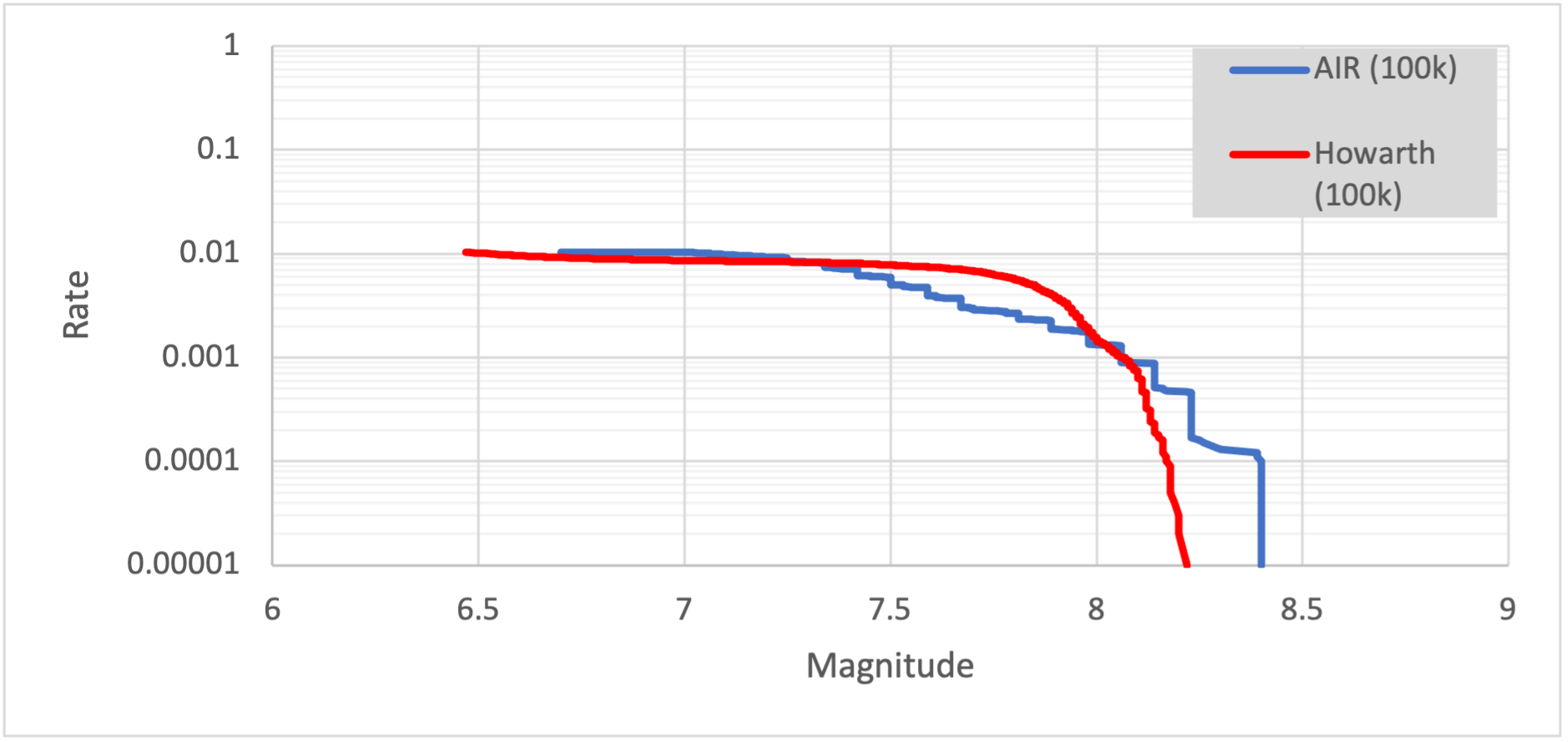
Although the total numbers of events larger than M7.0 and M8.0 in a 100K simulation for the two segments are similar to those in the AIR time-dependent (TD) model (Figure 2), there are many more earthquakes in the magnitude range of 7.75 to 8.0 in the Howarth et al. model (Figure 1). AIR’s model was based on the Litchfield et al. (2014) fault model with additional rupture scenarios for larger magnitude, longer rupture, and multi-segment rupture events. The magnitude distribution in the AIR model is more spread out across a broad range of magnitudes, including events with magnitudes larger than 8.2 that rupture the entire Alpine Fault. The Howarth2021 model only includes magnitudes up to 8.2.
The Howarth2021 model is considered preliminary. It is still unknown if the working group will consider this model as one of the alternative views in NSHM2022 or with what weight—especially regarding the conditional probability for the next Alpine rupture—if it is adopted.
The NSHM is widely used by government and industry in New Zealand to estimate the likely impact of earthquakes on the country’s land, buildings, and infrastructure. Incorporating the best available science to deliver scientific estimates of earthquake shaking helps New Zealand build resilience and manage risks to its safety, security, and economy from seismic events.
References
McVerry, G. H., J. X. Zhao, N. A. Abrahamson, and P. G. Somerville (2000). Crustal and subduction zones attenuation relations for New Zealand earthquakes, Proceedings of the 12th World Conference of Earthquake Engineering 2000, Auckland, New Zealand.
Lichfield N.J., Van Dissen R., Sutherland R., Barnes P.M., Cox S.C., Norris R., Beavan R.J., Langridge R., Villamor P., Berryman K., et al. 2014, A model of active faulting in New Zealand. New Zealand Journal of Geology and Geophysics. 57(1):32-56.
Stirling, M., G. McVerry,M., Gerstenberger, N. Litchfield, R. Van Dissen, K. Berryman, P. Barnes, L. Wallace, P. Villamor, R. Langridge, et al. (2012). National seismic hazard model for New Zealand: 2010 update, Bull. Seismol. Soc. Am. 102, 1514–1542.
Howarth, Jamie D.; Barth, Nicolas C.; Fitzsimons, Sean J.; Richards-Dinger, Keith; Clark, Kate J.; Biasi, Glenn P.; Cochran, Ursula A.; Langridge, Robert M.; Berryman, Kelvin R.; Sutherland, Rupert, (2021), Spatiotemporal clustering of great earthquakes on a transform fault controlled by geometry, Nature Geoscience, 14314.
Wallace L.M., J. Beavan, R. McCaffrey, and D. Darby, (2012), Subduction zone coupling and tectonic block rotations in the North Island, New Zealand, JOURNAL OF GEOPHYSICAL RESEARCH, VOL. 109, B12406
McVerry, G. H., J. X. Zhao, N. A. Abrahamson, and P. G. Somerville (2006). Response spectral attenuation relations for crustal and subduction zone earthquakes, Bull. New Zeal. Soc. Earthquake Eng. 39, 1–58.
Reliably assess and manage seismic risk with AIR earthquake models.
