


Distinct and independent events are fundamental to event-based probabilistic natural catastrophe risk models. Defining events for some natural catastrophes such as earthquakes and hurricanes is relatively simple, owing to their infrequent occurrence and clearer extent, both in time and space. Identification and demarcation are not so straightforward for inland flood events, however, particularly for a large country like the U.S. Often, rainstorms occur in quick successive spells, with significant interaction, and extensive river networks carry floodwaters far downstream, significantly extending the space-time boundaries of flood events and further increasing the potential of additional rainstorms to overlap and confound signals.
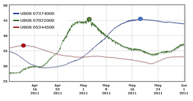
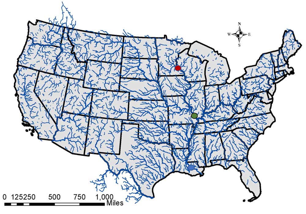
In 2008, for example, numerous rainstorms from January to July led to major flooding in several states across the Midwest. Significant snowmelt from the previous winter‘s above-average snowpack and the streak of rainstorms during January to May saturated the ground when the heaviest of rains occurred in June. The resultant Midwest Flood event lasted for roughly 42 days, from May 21 to July 1, and created substantial flooding and damage in Illinois, Indiana, Iowa, Kansas, Michigan, Minnesota, Missouri, Nebraska, Oklahoma, South Dakota, and Wisconsin.
Frequency, duration, and spatial extent characterize flood events. Important guiding principles for defining events followed in the AIR U.S. Inland Flood model include:
- Downstream floods belong to the same event if within a reasonable time
- Hydrological response can have an extended memory of precipitation and therefore events may include multiple meteorological systems that affected a flood event
- A generalized methodology should be formed considering physical limitations
- Sensitivity of event definition parameters should be tested with respect to event duration, number of events per year, and event spatial extent.
In the AIR model, continuous hydrological modeling at an hourly time interval is performed throughout the 3.2 million square miles of the model domain to obtain peak flows and peak 24-hour precipitation for each of the 345,000 distinct unit catchments over 10,000 years of the stochastic precipitation catalog. The model’s event definition algorithm then uses the peak flow and 24-hour peak precipitation for each year and groups them based on time and space by applying a series of agglomerative hierarchical clustering analyses.
Peak flooding instances are grouped in a multistep process, first based on time, and then on space. The initial time grouping of seven days, for example, reflects a traditional 168-hours clause. The last step is to stitch events together if they meet additional spatial or temporal criteria to ensure continuity of events outside the application of an arbitrary space or time threshold and to reflect situations similar to the flood wave propagation along larger rivers.
To summarize, AIR’s event definition algorithm satisfies the goal of having a consistent and yet flexible framework to organize flooding instances into sensible groups that realistically reflect characteristics of historical flood events.


