Natural Resources Canada (NRCan) announced they will be releasing their 6th Generation Seismic Hazard Model (SHM6) this year for incorporation into the 2020 National Building Code of Canada (NBCC2020). The hazard model is updated every five years or so to ensure that the building code is based on the most accurate and up-to-date knowledge.
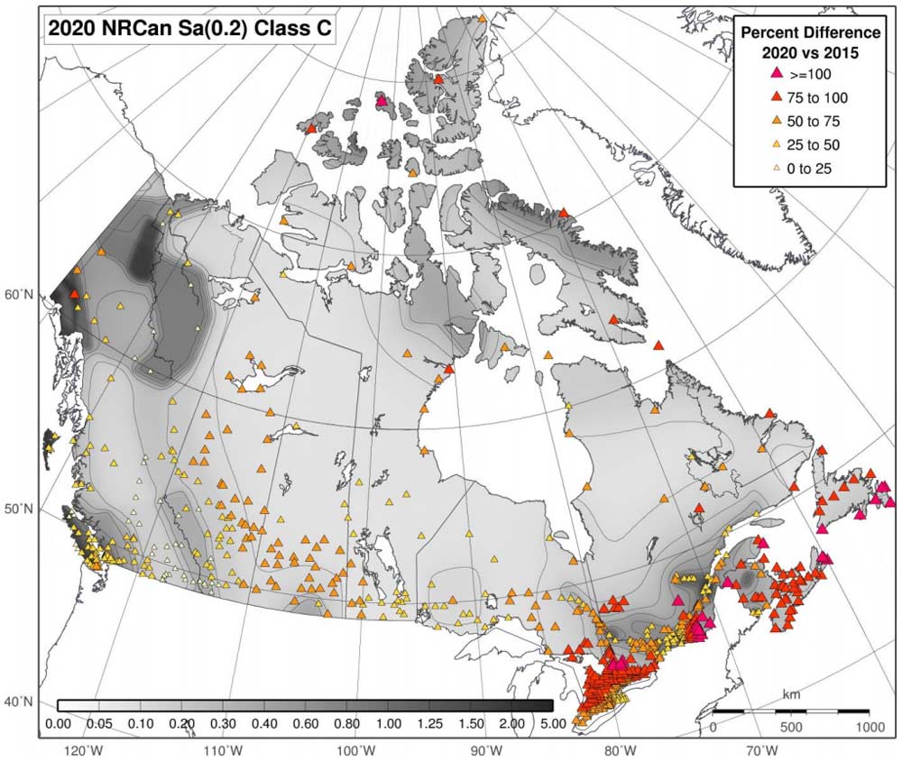
Compared to NRCan’s previous hazard model (SHM5), SHM6 increases hazard 50% overall, but this increase can vary greatly based on location (Figure 1). A large portion of the increase comes from updates to the ground motion model and site amplification terms, with smaller contributions from updates in British Columbia surrounding the Cascadia subduction zone. Potential changes to losses depend not only on hazard, but also the regional exposure and vulnerability.
Ground Motion Model Changes
A major contribution to hazard increase in Canada for SHM6 in comparison to SHM5 stems from updates to the ground motion model. Ground motion models often cover three broad tectonic categories: active crustal regions, stable crustal regions, and subduction zones. It has been observed throughout the data in the past decade that significant differences exist in how seismic waves attenuate within each of these three broad tectonic categories and thus different models must be developed to best characterize the ground motion in each region. For example, the multi-year collaborative NGA-East project completed in 2018 focused on characterizing ground motions for tectonically stable regions such as those east of the Canadian Rocky Mountains.
SHM5 used representative suites of GMPEs for each of three regions—West, Stable, and East—whereas SHM6 applies a classical logic-tree approach. SHM6 applies weights to selected ground-motion models across four tectonic regions (Cascadia Subduction Inslab, Cascadia Subduction Interface, Western Active Crust, and Eastern Stable Crust) to properly account for the epistemic uncertainty.
The most widespread increase in hazard is seen in Eastern Canada where some ground motion models from the NGA-East project were implemented in combination with an SHM5 ground motion model at 50%/50% weight. It was not possible to fully implement all 17 NGA-East ground motion models due to time constraints, but in due course they will all be adopted. This will lead to further hazard increases (up to 40%) in Eastern Canada for subsequent updates. In tectonically active western Canada, the adoption of four NGA-West2 ground motion models with equal weights led to some changes less significant than those from the adoption of NGA-East in Eastern Canada.
SHM6 also implements a new approach to modeling site effects and improved confidence in characterizing site effects. Site amplification is now quantified as a function of Vs30 (averaged shear wave velocity in the upper 30-meter soil), and hazard results can be provided directly for user-specified Vs30.
Changes Near the Cascadia Subduction Zone
It is well known that western Canada lies in the so-called Pacific Ring of Fire, where roughly 81% of the world’s largest earthquakes occur, and has the largest concentration of earthquakes in the country. The Cascadia subduction zone along the southwestern coast of British Columbia has the potential to produce an M9.0 or greater earthquake every 200 or so years and smaller earthquakes more frequently. The cities of Vancouver and Victoria are vulnerable to such earthquakes.
Changes to the historical record of large earthquakes along the Cascadia subduction zone, improved model characterization of the Cascadia subducting slab, and the incorporation of new potentially active faults near Victoria, BC, have resulted in smaller hazard increases in the Cascadia subduction region than in other parts of Canada.
A comprehensive study published in 2017 found evidence for additional events in the northern section of the Cascadia subduction zone near southwestern British Columbia. This has decreased the earthquake recurrence times along the subduction zone from 525 years in SHM5 to 434 years in SHM6. It also drove an approximately 8% broad increase for all spectral periods and probabilities in seismic hazard from the Juan de Fuca segment of the Cascadia subduction zone to southern British Columbia. Additional modeling improvements have changed the Cascadia in-slab source geometry to more accurately characterize the depth and seismicity rates of the deep earthquakes found in the subducting slab below the Straits of Georgia. This resulted in a short-period hazard increase of approximately 5% in Vancouver and 10% in Victoria.
Several studies published in recent years have identified a potentially active crustal fault system within 5 km of Victoria called the Leech River Valley Fault, with three possible M>6.0 earthquakes over the past ~9,000 years. It is thought that this system acts in concert with surrounding crustal faults to help accommodate regional transpressional forces from the Cascadia subduction zone.
The research also postulates that the Leech River Valley Fault could be connected to the Devil’s Mountain Fault that runs under the Juan de Fuca Strait and into the State of Washington in the U.S. NRCan’s implementation of the Leech River Valley and Devil’s Mountain Fault System in SHM6 results in very localized increases in hazard of around 5-6% at short spectral periods for Victoria, BC.
Potential Direction of Loss Changes to AIR’s Model
In western Canada, the SHM6 change to the seismicity model brought it closer to the 2014 USGS model for earthquakes in the Cascadian subduction zone, including the shallow interface and deep in-slab earthquakes. Since AIR’s Earthquake Model for Canada is based primarily on the 2014 USGS hazard model for this region the change in the proposed SHM6 hazard model update, which has a minor impact on the 2,475-year return period (2% in exceedance probability) hazard in western Canada, may not impact it in any significant way. The addition of the newly discovered active fault near Victoria, BC, however, may have some significant, but localized impact. Overall, the impact on the ground motion model change in western Canada is expected to be relatively minor.
In eastern Canada, the implementation of the results from the NGA-East project, along with a switch to a classic logic-tree combination of GMPE to account for epistemic uncertainty, drove a large increase in hazard from SHM5 to SHM6. Because AIR’s 2017 U.S.-Canada models have a different ground motion model than SHM5 for stable continental regions, the hazard changes from SHM5 to SHM6 will not necessarily directly translate for AIR’s updated view. Many of the GMPEs used in the 2014 AIR US-Canada model will need to be updated with more recent and up-to-date GMPEs. AIR’s preliminary calculations implementing NGA-East for eastern Canada earthquakes showed some higher hazard at close distances as it compared to the 2014 AIR Canada model. At further distances, the preliminary hazard change appears to either slightly decrease or stay nearly the same for eastern Canada. The impact on loss due to ground motion model change is expected to be more complicated than the change pattern shown on a 2,475-year return period hazard map (Figure 1). AIR will have a more detailed evaluation result once SHM6 is finalized later this year.
Quantification of Risk from Hazard Is Ongoing
A more recent multi-year effort by Natural Resources Canada (NRCan) in collaboration with the Global Earthquake Model Foundation (GEM) and the Institute for Catastrophic Loss Reduction (ICLR) has focused on developing a national publicly available earthquake risk model for Canada. The overall goal of this endeavor is to increase Canada’s understanding of earthquake risk and take steps to invest in measures that mitigate the potential consequences of such catastrophic events.
Using its seismic hazard model in concert with its physical and social vulnerability models constructed with a combination of settled area boundaries, 2016 national census information, land use classification, and demographic characteristics, Canada now has a preliminary view of risk it can provide key stakeholders.
The effort has been able to identify a small subset of buildings across Canada driving more than 70% of Canada’s earthquake risk, most of which are constructed with concrete or unreinforced masonry. The current NRCan model doesn’t include infrastructure beyond buildings such as bridges or any secondary perils such as fire following, liquefaction, landslide, or tsunami. While still preliminary, the results from this project are helping to inform seismic retrofit policy development for Vancouver, which would bring building codes closer to standards seen in California, for example.
Next steps
Canada’s SHM6 is currently undergoing peer review and will be released within the next couple months as a “proposed model” while the review process continues. NRCan’s current plan is to release the earthquake hazard and risk models together by the end of 2020. Both will be formally implemented into the GEM OpenQuake Engine. Once released, AIR will evaluate the changes and see whether or how they will be incorporated into future model updates.
Canada Earthquake Risk: Learn about AIR’s solution to provide a comprehensive view of risk