


For the first time in the satellite era Somalia, in the Horn of Africa, was struck by a hurricane-strength cyclone on November 22, 2020. Benefiting from low wind shear and warm ocean waters, Gati intensified rapidly from a depression with 40 mph winds to a Category 3-equivalent storm with 115 mph winds in a 12-hour period shortly before it made landfall over the city of Hafun at about 6 p.m. local time.
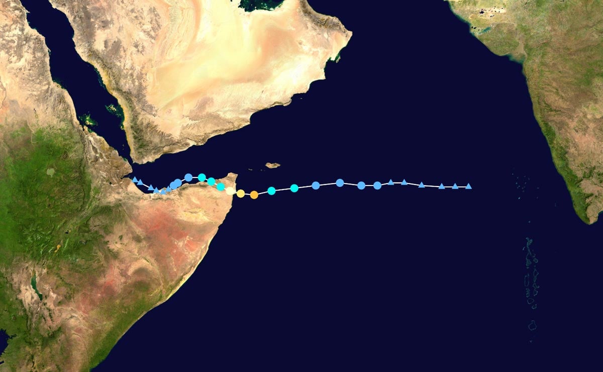
Gati’s rate of intensification was more than four times the criteria for rapid intensification: Over twice the wind speed increase in half the time. Shortly after this hyper-strengthening, Gati made landfall with one-minute sustained winds of 105 mph. It was the strongest tropical cyclone ever recorded in the North Indian Ocean and the greatest 12-hour increase in wind speed on record in the region. Prior to Gati the strongest cyclone to strike Somalia was a storm that brought 60 mph winds in 2018.
Heavy Rainfall
As well as delivering hurricane-strength winds to a region ill-equipped to cope with them, Gati delivered prodigious amounts of precipitation. In the space of just 24 hours, 5 inches (128 mm) of rainfall was recorded in Bosaso, the largest city in the autonomous state of Puntland and the region’s commercial center. Balidhidhin and Balli Dhiddin in Puntland’s Bari region recorded 4 inches (103 mm). In a single day, far more rain fell than this arid region usually experiences in an entire year.
The impacts of Gati were experienced chiefly in parts of Puntland State‘s Bari region and in the Sanaag region of Somaliland, an autonomous region in northwestern Somalia, but extended also into Yemen and western Oman. Tens of thousands of people were displaced by the storm in Somalia, at least nine lives were lost (most of them at sea), and damage on land was considerable. Widespread flash flooding occurred, disrupting communications and transportation. Roads, telecommunications, and infrastructure suffered severe damage; in the town of Hurdiya in Bari more than 20 houses were reportedly destroyed.
An Active Decade
While tropical cyclones are not the first atmospheric peril that comes to mind when thinking of Africa, they do make landfall along the eastern coastline on both sides of the equator. More frequent activity occurs in the south: Approximately 30 storms—some of which have made landfall at hurricane strength—have impacted southern Africa this century.
Landfall activity to the north is rarer. One reason is the latitudinal extent of the coast that is exposed to the Northern Indian Ocean. Somalia is basically south of 10 degrees north and, given the weakness of the Coriolis Effect near the equator, it is difficult to spin up such strong cyclones and have them impact that country. Still, Somalia has seen 10 tropical cyclones since 2000, although Gati is the strongest.
The last decade has definitely been the most active, with about three times the normal activity during the 2010s than in the 1980s, 1990s, or 2000s. Some of the strongest activity has come late in the year after the Asian Monsoon trough has migrated back toward the equator as it typically executes its annual see-saw north-south behavior. The post-monsoon phase provides a low-shear environment, and the water is still plenty warm.
Increasing Activity?
Climate change may be playing a role in tropical activity over the region. The average temperature of the tropical Indian Ocean has been increasing steadily since 1950 at a rate of 0.15°C/decade. The Arabian Sea, in particular, has seen increased activity of very strong storms.
The first extremely severe cyclonic storms (ESCSs) ever observed in the Arabian Sea were in 2014 and 2015 (Murakami et al. 2017). The AIR Tropical Cyclone Model for India included such possible activity impacting India from the Arabian Sea when it was released in 2012 . Several studies have documented the increased tropical cyclone activity over the Arabian Sea in general. A very recent study by Knutson et al. (2020) concluded that anthropogenic forcing has contributed to the increase in ESCSs (equivalent to Category 3 and higher) in the Arabian Sea during the post-monsoon phase of the season (October-November).
The continued warming of India Ocean water from climate change is expected to continue increasing tropical cyclone activity across the Arabian Sea. And, while a storm like Gati was a long time coming for Somalia, it may become a more frequent occurrence by later this century.
Learn more about AIR’s Climate Change Practice


