On January 7, 2020, Puerto Rico experienced an Mw 6.4 earthquake located just 8 km offshore the southern coast, near Indios. It came after a series of more than 500 smaller earthquakes in the preceding weeks as well as an Mw 5.8 quake one day earlier, which destroyed Punta Ventana, one of Puerto Rico’s most famous rock formations.
Unlike the 2014 earthquake in the Puerto Rico Trench of comparable size, which caused minimal damage, Tuesday’s 6.4 event collapsed an elementary school, necessitated hospital patient evacuations, killed one man in his home, and injured several others. In addition, power for most of the island was disrupted; as of Wednesday, about 1 million customers still had no electricity, one quarter of whom also had no running water due to lack of power, according to the New York Times. The power authority was generating about 40% of the amount of power normally needed at this time of year by Wednesday evening. Puerto Rico’s Governor Wanda Vásquez has declared an official state of emergency.
Geologic Setting
While small earthquakes (Mw≤4) are not uncommon for this area and are regularly detected by the Puerto Rico Seismic Network, events of larger magnitudes are more unusual. The island sits atop the Puerto Rico – Virgin Islands (PRVI) microplate, beneath which the North American Plate is subducting in the north at the Puerto Rico Trench and the Caribbean Plate is subducting at the Muertos Trough to the south, although the details of the southern plate boundary along the Muertos Trough remain the subject of some debate.
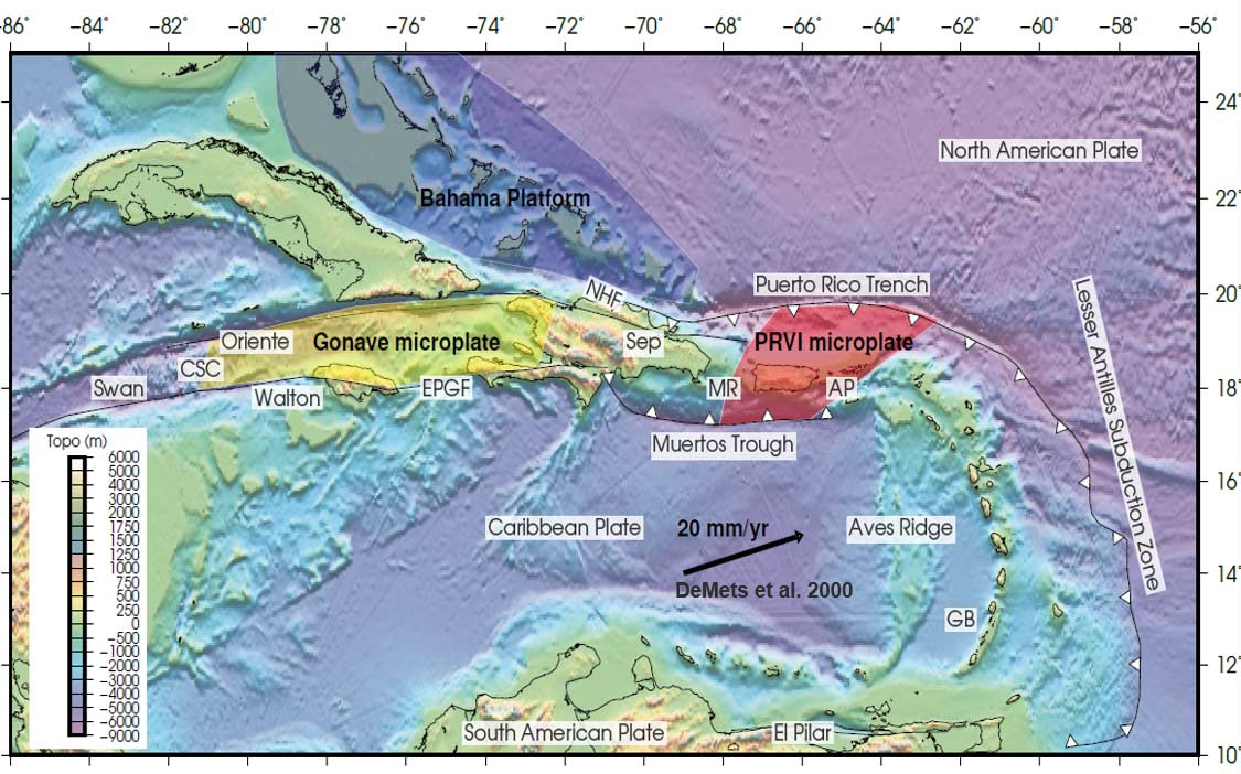
Both the Puerto Rico Trench and the Muertos Trough have the potential to generate large earthquakes that could impact Puerto Rico as well as initiate a tsunami. The 2014 earthquake occurred along the Puerto Rico Trench and was therefore not unexpected in terms of size and rupture type. This week’s event, however, was an oblique strike-slip earthquake indicating that it did not occur on the Muertos Trough. Instead, this earthquake occurred on an intraplate fault at shallow depth, roughly 13.5 km as reported by the USGS. Researchers at both the University of Puerto Rico - Mayagüez and the USGS have reported that the recent events are occurring in the broad offshore deformation zone near the Guayanilla Canyon; the deformation zone may continue onshore as the recently recognized Punta Montalva Fault. The focal mechanisms of this earthquake sequence are more complicated than a single fault system could produce, which suggests that the release of stress on one fault may be triggering earthquakes on nearby faults.
The number and intensity of foreshocks and aftershocks associated with the January 6 and January 7 events is unprecedented since the Puerto Rico Seismic Network began operation in 1974.
Puerto Rico’s Earthquake Preparedness
Unfortunately, due to the inherent low seismicity of Puerto Rico, earthquake mitigation is not top of mind, leaving residents inadequately prepared. Vásquez stated in a news conference on Tuesday that the country’s earthquake preparedness plan had not been updated in more than a century; it was last revised following the 1918 Mw 7.5 earthquake and tsunami that caused severe damage and killed more than 100 people.
This week’s earthquake highlights the shortcomings of the existing earthquake preparedness program. Many towns along the south coast had interrupted communications and were not receiving updates, so many residents stayed put because they did not know which areas were safe. Unlike hurricanes, which can be anticipated and prepared for, earthquakes occur with no warning. With the country already reeling from the impacts of Hurricane Maria, the January 7 earthquake is impeding ongoing recovery efforts and lowering morale.
Read “The 2010 Haiti Earthquake: From Devastation to a Deeper Understanding of Caribbean Seismicity”