


Several climate signals influence hurricane activity in the Atlantic basin and are taken into account by agencies when developing their respective pre-season forecasts.
When it comes to media coverage, the influence of the El Niño-Southern Oscillation (ENSO) hits the headlines most frequently. Atlantic sea surface temperatures (SSTs), which are impacted by the Atlantic Multidecadal Oscillation (AMO)—a phenomenon that takes decades to change phase—are also frequently discussed. Other oft-mentioned factors include climate signals that cycle over shorter time periods (weeks or months) such as the North Atlantic Oscillation (NAO) and the Madden-Julian Oscillation (MJO).

During the 2019 season, mentions of the natural phenomenon the Saharan Air Layer (SAL) in relation to Atlantic hurricane activity have soared in the media. This raises the question: How does Saharan dust impact Atlantic hurricanes?
The SAL and Its Impact on Atlantic Hurricanes
To answer that question, it’s important to understand what the Saharan Air Layer (SAL) is and what its meteorological and environmental characteristics are.
The prevalent atmosphere over the Sahara Desert in North Africa—the SAL—is a very hot, dry layer of air laden with dust. It forms from spring to early fall and moves out over the cool, moist surface air of the tropical North Atlantic Ocean every three to five days. Extending upward between 5,000 and 20,000 feet, the SAL is about 50% drier than tropical air. It is also associated with strong winds of up to 55 mph.
The moisture usually found in tropical air facilitates the development of storm convection and longevity. The dryness of the SAL, on the other hand, can inhibit hurricane formation by impeding the onset of convection by reducing the environment’s convective instability and reducing the ambient moisture.
Depending on the timing of the interaction with the SAL, its presence can inhibit a storm from developing due to the reduction in instability or the SAL’s dry air mixed into a tropical system can lead to its dissipation. In addition, the strong winds associated with the SAL can increase vertical wind shear, which can lead to hurricane dissipation. Increased wind shear changes the vertical flow of a tropical system, causing the outflow to be out of phase with the inflow, thereby inhibiting efficient ventilation ,which is key to the ability of a tropical cyclone to maintain its intensity.
In addition to the direct impacts of the SAL on hurricane activity, the SAL can impact hurricane activity indirectly through its impact on SSTs. The SAL contains large amounts of dust that reflect incoming solar radiation which in turn causes sea surface temperatures to cool, reducing the amount of energy available and impacting the likelihood for storms to develop into Hurricanes.
Hurricanes Claudette and Helene Meet the SAL
According to the National Oceanic and Atmospheric Administration (NOAA), “the SAL can cover an area the size of the continental U.S. and has been tracked as far west as the Caribbean Sea, Central America, and the Gulf of Mexico.” Because it can travel so far, the SAL’s presence—or sudden lack thereof—can change a hurricane forecast within hours of potential landfall.
This occurred in 2003, for example, when Claudette rapidly intensified into a hurricane 15 hours prior to landfall on the central Texas coast. Claudette formed from a disturbance caused by an African Easterly wave. Within the same wave a SAL outbreak propagated west as well and the two remained together for most of the storm’s evolution. It was the SAL and Claudette parting onto separate tracks that enabled Claudette to intensify.
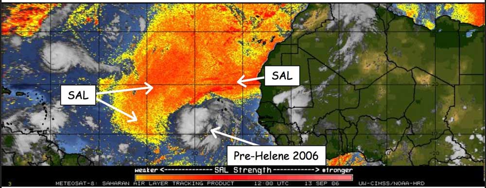
The SAL also impacted Hurricane Helene, delaying its intensification prior to becoming the strongest storm of the 2006 Atlantic hurricane season. During the first two days following Helene’s development as a tropical depression Saharan dust was observed within the storm’s periphery (Figure 2) impeding its intensification. Only after the dust moved west of the storm did Helene’s intensification accelerate, reaching Category 3 status four days later.
The SAL and the 2019 Atlantic Hurricane Season
While there are agencies that provide forecasts for the SAL, these forecasts are inherently uncertain. It is difficult to anticipate when the SAL will move over the Atlantic or how extensive it will be when it does. When it moves over the ocean, however, its progress can be tracked. Infrared satellite imagery can show the current spatial location of the SAL, but surprises may lie ahead, as evidenced by Hurricane Claudette. The SAL does impact Atlantic hurricanes, but the nature and extent of that impact are the subjects of ongoing research.
Read our article previewing the 2019 Atlantic hurricane season


