Southern California was just rocked by two major earthquakes only 34 hours and ~7 miles (11 km) apart. An M6.4 foreshock in the region between the Searles Valley and Ridgecrest on July 4 was quickly followed by a significantly more powerful M7.1 mainshock on July 5. No earthquake this strong has struck California since the M7.1 Hector Mine earthquake of October 16, 1999, which occurred 128 miles (205.76 km) to the south. Thousands of aftershocks have been felt in the surrounding region; these will likely continue for years to come, but their magnitude will drop off over time.
What Happened? Knowns vs. Unknowns
This complicated sequence of earthquakes occurred far from major population centers and has no obvious implications for imparting additional stresses on the San Andreas Fault and triggering “the Big One.” They struck in a region within a zone of right- and left-lateral transform faulting known as the Walker Lane. This general region runs parallel to the San Andreas Fault but to the east of the Sierra Nevada Range (Figure 1). It has experienced several major earthquakes; in addition to the 1999 M7.1 Hector Mine earthquake, notable examples include the 1872 M7.6 Owens Valley earthquake, the 1992 M7.3 Landers earthquake, the 1932 M7.2 Cedar Mountain earthquake, and the 1952 M7.3 Kern County earthquake.
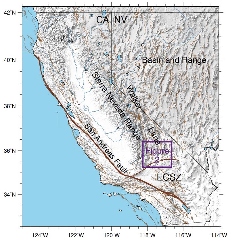
Of the stress caused by the relative right-lateral motion between the Pacific and North American Plates, which is responsible for a large portion of seismicity in California, up to 75% is accommodated by the San Andreas Fault. Much of the remaining plate motion is accommodated in the Eastern California Shear Zone in California, the Walker Lane in California and Nevada, and the Basin and Range in Nevada and Utah. Geologically speaking, the Walker Lane is a relatively young system that contains a complex series of faults, many of which have not been mapped because they are either difficult to trace or don’t reach the surface. In comparison, the San Andreas Fault contains one singular, mature, and well-mapped strand.
While it is well known that the Walker Lane is active, it is hard to interpret and therefore unknown where large earthquakes will occur in this general fault zone. This is an issue because projects such as Uniform California Earthquake Rupture Forecast Version 3 (or UCERF3), which are used to create forecasts of potentially damaging earthquakes, depend on accurately traced fault strands. Here, most large faults including the one from the earthquake remain unmapped and the probabilities are not fully captured in such models.
Earthquake Sequence Evolution
This month’s series of large quakes occurred on a pair of conjugate faults—a set of fractures in the earth roughly perpendicular to each other that follows standard Mohr-Coulomb faulting theory. Examples of conjugate faulting features in California and Nevada are abundant. The most recent example of an earthquake sequence in this area involving two conjugate faults is the 2016-18 Nine Mile Ranch Sequence near Hawthorne, Nevada.
The July 4 M6.4 earthquake occurred at the intersection of a conjugate fault system initiating left-lateral slip onto a previously unmapped northeast-trending fault paralleling the Garlock Fault Zone. As the sequence grew, the M6.4 triggered the much larger M7.1 earthquake on the other previously unmapped northwest-trending strand displaying right-lateral slip. This strand parallels the Sierra Nevada Range and the San Andreas Fault.
As the sequence progressed from the M7.1 earthquake, both aftershocks and fault slip were observed as far south as the Garlock Fault Zone and as far north as the Coso Volcanic Field (Figure 2). An M5.4 aftershock occurring an hour after the M7.1 mainshock subsequently triggered a swarm of earthquakes within the Coso Volcanic Field. It is estimated that the Garlock Fault Zone, the Coso Volcanic Field, and the Owens Valley Fault Zone (OVFZ) all received positive stress changes as a result, bringing these specific regions closer to failure and making them more likely to produce aftershocks and large earthquakes in the future.
Reported Damage
The two earthquakes between Searles Valley and Ridgecrest were powerful events, and the shaking was felt as far afield as San Diego and Sacramento in California; Phoenix, Arizona; and Las Vegas, Nevada. It was reportedly felt even in northern Mexico. But the quakes occurred in a sparsely populated region of the Mojave Desert, and little damage was experienced.
The largest town in the immediate area, Ridgecrest, is about 100 miles from Los Angeles and has a population of approximately 29,000. Some homes and businesses were severely damaged, reportedly beyond repair in a few cases, but most construction dates from the 1970s or later and performed well. The much smaller town of Trona some 30 miles to the east in the Searles Valley did not fare so well. There most construction is considerably older and predates modern building codes.
The surface rupture from the quakes damaged roads in the area, and a landslide further blocked access to Trona. Most of the damage reported consists of gas leaks, power outages, fires, toppled chimneys, and items falling from shelves in stores.
A Protection Gap
The last earthquake to cause major destruction in the region was the M6.7 Northridge earthquake of 1994. It produced the largest ground motions ever recorded in an urban environment, heavily damaging more than 40,000 structures across several counties. Insured losses totaled USD 12.5 billion—substantially more than the amount of earthquake insurance premiums collected during the previous 80 years. With the current building inventory at risk, AIR estimates that it would cause USD 16 billion in insured loss if it were to occur today. If an M7.1 event were to strike Los Angeles today, AIR estimates that insured losses could be as high as USD 50 billion.
While this month’s events don’t themselves herald “the Big One,” the activity is likely to add or reduce stresses on the nearby Garlock Fault—which produced the M7.3 Kern County earthquake in 1952—and potentially trigger a future rupture; it might also trigger the Owens Valley Fault Zone, which last ruptured in 1872.
Statewide, only about 15% of California homeowners have earthquake insurance (Coverage A). Those who purchase earthquake policies are often the ones most at risk from earthquakes, leading to a market characterized by adverse selection. In Los Angeles County, for example, the take-up rate is about 20%, but in Kern County (where Ridgecrest is located) it is 15%. The “Big One” will strike one day, and until it does California will continue to experience multiple quakes, some of them major and damaging. There is still a significant protection gap in the state that needs to be addressed. This time California was lucky.
View the infographic: Who Will Pay for the Next Great California Earthquake?