


My Memorial Day weekend was spent, as it has been for several years now, at Ferry Beach near Saco on the coast of southern Maine. The area is a popular vacation destination because Saco Bay is blessed with 7 miles of sandy beach.
Unfortunately, the short section of shoreline between Ferry Beach and the Saco River is regularly damaged by storm surge. The problem is a highly localized one, likely caused by the Corps of Engineers’ construction of a 6,600-foot long jetty at the mouth of the river in the late 19th century. Their goal was to improve the river’s navigability when Saco and neighboring Biddeford were major industrial centers.
The bay’s wonderful beach exists because sand is washed down the Saco River into the south of the bay, where storms and tides gradually spread it northward along the shoreline. Unfortunately, the jetty appears to be depositing sand too far out into the bay, leaving incoming Nor’easters and regular tides free to scour the adjacent stretch of beach without any hope of natural replenishment. This has accelerated the coastal erosion of about 2,500 feet of shoreline immediately north of the jetty for 150 years.
The shore is disappearing faster there than anywhere else in the state, and in the last 50 years Camp Ellis at the mouth of the Saco River has lost 38 homes. As the shoreline has been inexorably nibbled away at a rate of 2 to 3 feet each year, dunes, homes, roads, and half a neighborhood have vanished. Most of today’s beachfront properties were safely inland when they were constructed many decades ago! With each Nor’easter it seems additional damage is done. Pending a long-delayed Corps of Engineers remedial project designed to thwart the waves’ scouring action, the City of Saco and Camp Ellis residents have been doing everything they can to stave off further destruction.
Enhanced Defenses
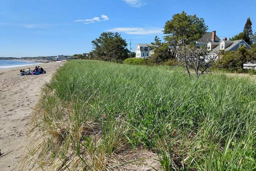
The bay is fringed with natural dunes, but portions in Ferry Beach were in poor condition and have been restored in recent years. In one project, funded with a grant from the State of Maine, the Ferry Beach Park Association trucked in 90 loads of sand to rebuild a short section of dune. Volunteers then planted the new dune with locally sourced native beach grass. Fences kept visitors off the planted areas while the beach grass established itself and still restrict beach access to a few designated locations. The dunes from Ferry Beach to Camp Ellis have now been restored and provide a natural sacrificial barrier to storm damage and surge. Behind these defenses one property has recently replaced the wooden fence on the seaward side of its lot with a steep miniature dune planted with dune grass to afford it extra protection.
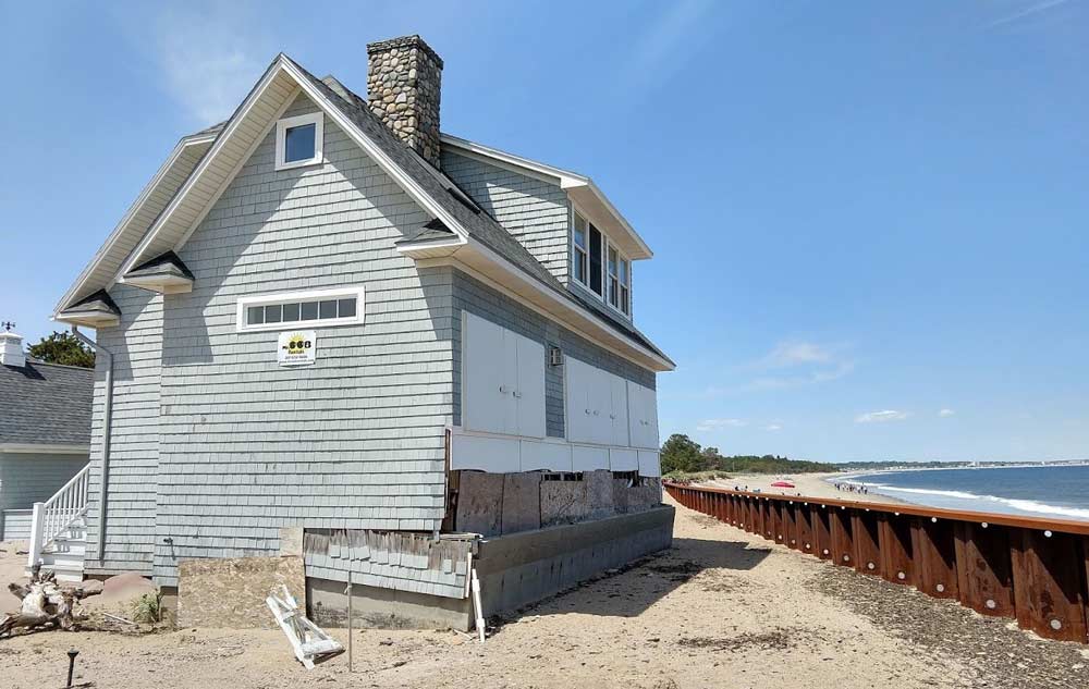
Closer to Camp Ellis the dunes were washed away years ago. Along the most vulnerable stretch of the shoreline close to the jetty a seawall of granite armor stone boulders has been built up higher than the lots behind it. The boulders need to be restacked annually.
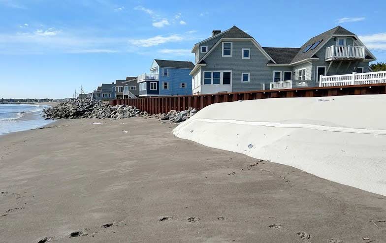
Several geotubes—temporary defenses that are essentially huge sandbags—have been installed. They are none too popular locally because they are unsightly and unnatural, and in some cases have succumbed to storm damage themselves, but they have clearly helped. More significantly, a short section of steel sheet piling retaining wall has been built recently to a height of about 3 feet above ground level. Behind it a narrow sandy path runs in front of the houses where Surf Street’s pavement used to extend not that long ago.
Elevated Homes
Anyone wandering along that narrow coastal path will be struck by the number of elevated homes they pass. Many of the beachfront properties at Camp Ellis are older structures that have only become coastal locations after the erosion of the shoreline and disappearance of the more easterly properties; others are newer construction. Several of these vulnerable homes have been elevated in recent years after experiencing severe storm damage, using a flow-through or pile foundations.
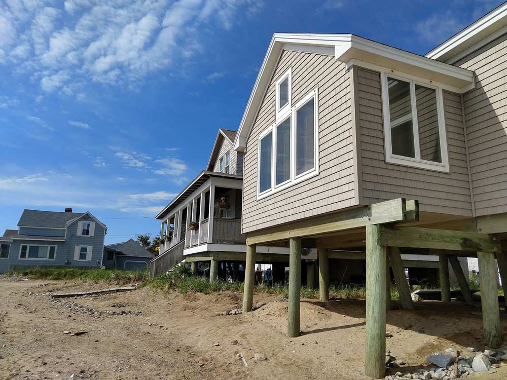
Saco participates in the National Flood Insurance Program (NFIP); if it did not, residents’ access to mortgage loans and disaster assistance would be severely limited. Flood insurance is available through the NFIP in exchange for the community’s commitment to practice sound land use management through the adoption of an approved Floodplain Management Ordinance that meets or exceeds the NFIP’s minimum requirements. Following hot on the heels of significant storm damage the city council in Saco unanimously enhanced its floodplain ordinance in 2013. New construction, homes being repaired after storm damage, or structures approved for renovations costing more than 50% of the home’s market value are now required to be elevated 2 feet higher than the federal compliance standards.
Another Step in the Right Direction
Improved coastal defenses and elevated structures provide the best protection from storm surge, but they don’t solve the underlying problem at Camp Ellis. After decades of fighting for a better solution, the Saco City Council voted unanimously in April 2019 to work with the Army Corps of Engineers to mitigate erosion in Camp Ellis. This hopefully means that the long-planned spur jetty to reduce the momentum of waves striking the beach can be built and that the accelerated erosion can be reduced. Rising sea levels and potential increases in storm severity are only going to exacerbate the area’s problems in the future—and Camp Ellis needs all the help it can get.


