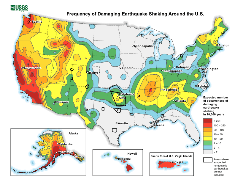
Seismic hazard maps use all available seismological and geological information to convey potential maximum expected ground motions over a particular period of time. In addition to providing the basis for earthquake provisions in building codes, they are an invaluable resource for the insurance industry and catastrophe model developers.

A suite of National Seismic Hazard Maps for the U.S. was created by the United States Geological Survey (USGS). The hazard component of the current AIR Earthquake Model for the United States is based on the most recent—the 2014 USGS National Seismic Hazard Map Project (NSHMP). These hazard maps, and the National Seismic Hazard Model (NSHM) that underlies them, are updated roughly every six years to ensure they incorporate the most accurate and up-to-date information.
The Collaborative Process of the USGS NSHM
The process for creating an update is a lengthy and collaborative one, designed to ensure that the latest research is taken into account. The USGS project first reaches out to the wider earthquake hazard community to request modeling updates for possible incorporation. Having received responses, the project develops a proposed update for the model, which underlies the NSHMP. Next, the project hosts workshops to solicit feedback from the scientific community. Following this consultation process a draft manuscript of the reviewed and revised proposal is made available on the USGS website for public comment and publication of the completed update follows.
The most recent draft proposal was available on the USGS website for public comment for a month in late 2018 and publication of the completed update is scheduled for summer 2019. Significant changes can be expected, particularly to ground motion prediction equations.
New Ground Motion Prediction Equations (GMPEs) Show Increased Shaking
The updated U.S. National Seismic Hazard Maps will show increased ground shaking in many (but not all) locations across the Central and Eastern U.S., as well as near the Los Angeles, San Francisco, Seattle, and Salt Lake City sedimentary basins. This is significant, as more people than ever before can be deemed to live and work in areas of high or moderate seismic hazard. This is because new ground motion prediction equations have been developed and used.
Global ground motion prediction equations (GMPEs) fall into three broad tectonic categories: active crustal regions, stable continental regions, and subduction zones. Significant differences in the distance and site scaling within these broad tectonic categories have been observed due to the availability of data in the past decade. More specifically, the recent multi-year collaborative NGA-East project has focused on characterizing ground motions for tectonically stable continental regions of the central U.S. (CEUS) east of the Rocky Mountains, whose seismic waves attenuate differently than those of the tectonically active western U.S. (WUS). The completion of the NGA-East project has prompted inclusion of these results into the 2018 update, which means there will be large-scale hazard changes in the CEUS.
The NSHM’s new ground motion model incorporates updated median estimates, modified assessments of the associated epistemic uncertainties and aleatory variabilities, and new soil amplification factors. The ground motions are mostly higher across the CEUS, due to the new ground motion models having higher sigma and amplification at periods less than about 2 seconds.
Sedimentary Basins and Tall Buildings at Risk
Site-specific basin amplification information for the Los Angeles, San Francisco, Seattle, and Salt Lake City sedimentary basins—where seismic waves can be significantly amplified—is now included in the NSHM. In the WUS, long period shaking for soft soils is higher over the deepest portions of the sedimentary basins. Amplification is not applied at periods below 1.0s spectral acceleration (SA); at 5.0s SA increases of around 40% can be expected when compared to default values. Changes such as the incorporation of basin depth terms have been a priority for defining the seismic hazard for tall buildings, which are more affected by long period shaking.
Other Updates
The NSHM’s seismicity catalog has been updated to include earthquakes that occurred between 2012 and 2017. In addition, improvements have been made to computer code and implementation details, among them a focus on server architecture, unifying the WUS source model, and use of cloud services.
Managing U.S. Earthquake Risk Now and in the Future
During AIR’s 2017 update to the Earthquake Model for the United States we incorporated some of the changes in the USGS NSHM 2018 update, such as the incorporation of a select set of sedimentary basins based on the available published literature at the time. We are currently working on reviewing all the NSHM 2018 changes for potential implementation in our model framework.


