
Multiple wildfires in both Northern and Southern California raged in October. Although these fires collectively burned through thousands of acres in different areas, one major factor driving them all is wind.
On October 30, the National Weather Service issued an extreme red flag warning for wildfire risk in Southern California. This is not a new category of warning, but rather enhanced language to convey the unusual severity of the risk. The situation was caused by what the National Weather Service described as “an anomalously amplified upper level pattern across the nation,” which created exceptionally strong gusty winds in California. Ordinarily at this time of year wildfire risk in the state is heightened by two seasonal winds in particular: the Santa Ana and Diablo.
What Are Santa Ana and Diablo Winds?
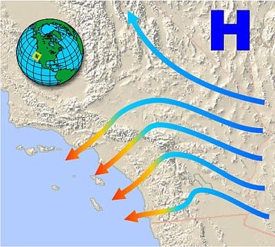
Santa Ana winds are named for one of the canyons through which they tend to blow, and Diablo winds are named for the Diablo Mountain Range, below which they tend to occur. The National Oceanic and Atmospheric Administration (NOAA) defines Santa Ana winds as, “a weather condition in which strong, hot, dust-bearing winds descend to the Pacific Coast around Los Angeles from inland desert regions.” They start out as an area of high pressure over the Great Basin—the dry and mountainous region between the Sierra Nevada and Rocky Mountains. The cooler air then begins to sink, drying and warming as it moves through the mountains—where tight spaces can increase wind speeds—and desert. The air then blows toward the Pacific Coast of Southern California as the strong, hot, extremely dry winds that we know as the Santa Ana winds (Figure 1).
According to NOAA, Diablo winds that can impact Northern California are, “Similar to Santa Ana winds in southern California. These winds occur below canyons in the East Bay hills (Diablo range) … They develop due to high pressure over Nevada and lower pressure along the central California coast.”
How Winds Impact Wildfire Activity
Wind gusts of more than 100 mph were reported in several locations during the last weekend of October in Northern California by the National Weather Service; more commonly reported were wind gusts of between 50 and 70 mph, which are still quite strong.
Before a wildfire even ignites, winds can impact wildfire activity. The warm, dry Santa Ana and Diablo winds can dry out potential fuels, including grasses and other shrubs and trees. The stronger, drier, and warmer the winds, the more they can dry out these fuels, increasing the potential for them to burn.
Once a fire starts, winds can expand the reach of the flames; in the case of wildland-urban interface fires, the winds drive the fire from undeveloped wildland to areas of human development. By casting embers onto structures and causing them to catch fire—called branding or spotting—the fire can damage or destroy homes in the area. The wildland-urban interface (WUI) is the area where the largest insured losses from wildfire in the United States have occurred.
While the fires so far this year have not caused the kind of destruction seen in the past two wildfire seasons, property loss from wildfire is expected to increase as the U.S. population grows and the WUI expands into areas with strong fire histories.