


When Tropical Cyclone Kelvin hit Western Australia in February and delivered heavy rainfall to the Kimberley coast, it thrust an unfamiliar term into the headlines—"the brown ocean effect.” Ordinarily, tropical cyclones intensify as they pass over warm waters and then diminish as they interact with land, but this is not always the case. Given the right circumstances storms can intensify after making landfall. In a warm environment, wet soils can harbor a surprising amount of latent heat. Under the right conditions this can fuel tropical cyclone development just as effectively as warm seas.
Three things are needed for the brown ocean effect—as this phenomenon is known—to be possible:
- A lower level of the atmosphere resembling a tropical atmosphere, with minimal variation in temperature
- Soils in the vicinity of the storm containing ample moisture (the brown ocean)
- Latent heat from evaporation of that moisture measuring at least 70 watts per square meter of soil, averaged over a large enough area
These conditions, and the storms arising from them, are known to occur in the U.S. and China, but are most likely to be encountered in Australia. Sands in Australian deserts are often very hot, and when soaked by the first rainfall from an approaching cyclone they can produce the kind of rapid heat exchange that feeds cyclone development, giving rise to the brown ocean effect.
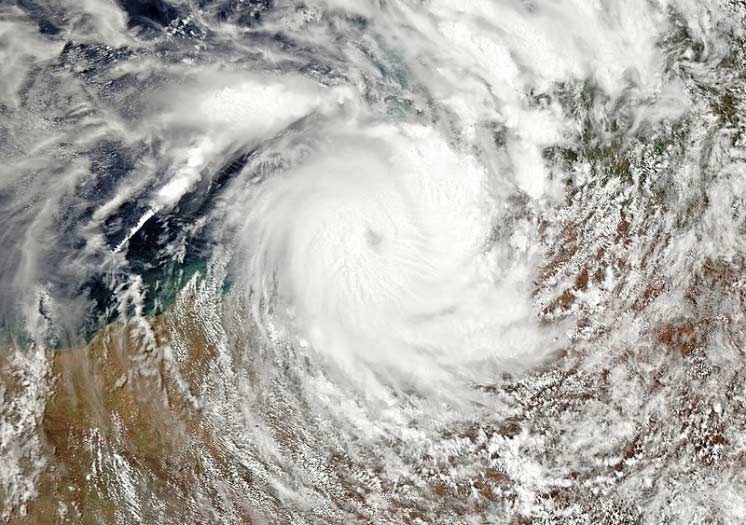
Storms like this attracted attention in the summer of 2007 after Tropical Storm Erin intensified over Texas, formed an eye over Oklahoma, and grew stronger than it had ever been over the ocean. Tropical Cyclone Kelvin formed an eye after making landfall near Anna Plains Station in northwest Australia on February 18 this year as a high-end Category 2 tropical cyclone on the Australian scale (equivalent to a high-end Category 1 storm on the Saffir-Simpson scale). If it wasn’t actually a brown ocean effect storm, it certainly lost its intensity extremely slowly. The Australian Bureau of Meteorology didn’t downgrade it below tropical cyclone intensity until it had spent 30 hours crossing the desert—where the flat terrain may be another factor in facilitating brown ocean effect storms.
A 2013 study funded by NASA looked at 227 tropical storms that formed between 1979 and 2008 and found that after making landfall, 45 of them had gained or maintained strength. Of these 45 storms, 17—among them Hurricane Sandy—were categorized as cold-core extratropical cyclones. Another 16, including Tropical Storm Erin, maintained their tropical warm-core characteristics over land. The researchers termed this group “tropical cyclone maintenance and intensification events” (TCMIs), and these are the brown ocean effect storms. The remaining 12 storms were deemed to fall into a hybrid category. According to another study, the latent surface heat flux from land surfaces that gives rise to the brown ocean effect can, potentially, be larger than that from the ocean—but only for short periods.
As if the term “brown ocean” were not colorful enough, in the land down under such tropical cyclones are now known as Landphoons, Terracanes, or Agukabams (which means “land storms” in the Ayapathu language of Cape York, Queensland). I think we’ll hear a lot more about the brown ocean effect in future as it becomes better understood, but I am not sure how widely these names will be adopted!
Understand your wind, rain, and storm surge risk with AIR tropical cyclone models


