


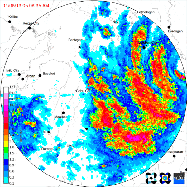
With minimal vertical wind shear and a long fetch of warm water, Typhoon Haiyan had a lengthy runway to spin up to super typhoon status before it made landfall in the Philippines before dawn on November 7, 2013 (Figure 1). Known as Yolanda in the Philippine Area of Responsibility (PAR), Haiyan was the strongest tropical cyclone on record in that country.
Haiyan left a lengthy trail of destruction from Micronesia to China and Vietnam, but its most serious damage was inflicted in the Philippines, where it devastated Tacloban City on the northeastern tip of Leyte Island (Figure 2). Figures vary, but at least 6,000 people lost their lives in the Philippines, half of them in Tacloban, which one reporter described in the immediate aftermath as a “corpse-strewn wasteland.”
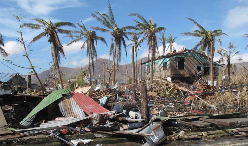
It wasn’t the wind, or the torrential rainfall that caused most of the appalling devastation and loss of life in Tacloban, but the storm surge. At least 90% of the structures in the city were damaged or destroyed by surge up to 4 meters (13 feet) high. Storm surge is a complex sub-peril, and several factors affect how much water comes ashore.
Wind Strength
A tropical cyclone's rotating winds create a vertical circulation of water in the sea beneath it that is disrupted by the ocean bottom as it approaches the shore; the water then has nowhere to go but up and inland. The larger the storm and the stronger its wind, the higher the mound of water pushed ahead of the system. Storm surge forms primarily on the right side of the storm track (in the Northern Hemisphere) because the cyclone's rotation and its steering winds move in the same direction there and push water ahead. Haiyan was a super typhoon when it made landfall with maximum 10-minute sustained wind speeds of 266 km/h (165 mph), according to initial estimates made by the Japan Meteorological Agency (JMA).
Storm Track
A storm impacting a coast with a shallow and gently sloping seabed will create a higher surge if its approach is perpendicular to the shore rather than at a more oblique angle to the shore and/or the seabed is steeper. Coastal orientation also matters, as a large volume of water forced into a narrow bay or inlet will mound up even higher.
Haiyan passed over the Leyte Gulf—which narrows at its northern end to form San Pablo Bay—heading almost directly for Tacloban City. Because of the storm's track and extreme winds, and the bathymetry and orientation of San Pedro Bay, an exceptional storm surge was funneled into the shallow bay between Leyte and Samar islands and into Tacloban City.
Topography
The contours of the coastal landscape determine how far inland storm surge will penetrate. Steeper slopes lead to more rapid attenuation, but low-lying terrain will enable surge to penetrate far inland. During Hurricane Ike in 2008 surge was able to reach nearly 30 miles into some parts of Texas. Most of Tacloban’s populated area is less than 5 meters (16 feet) above sea level, and there were no coastal defenses to stop the surge from inundating the city.
Timing
Tides vary in height from place to place because coastal geography can amplify or reduce tidal ranges. The state of the tide also varies temporally; as well as rising and falling twice daily, tides vary on a monthly cycle. The full moon and the sun pulling together create the highest part of the monthly tidal cycle, and the difference between high tide and low tide is least during a half moon.
Because storm surge comes on top of the usual tidal pattern for the area, tidal variation can do much to determine whether storm surge has a large or small impact. New York City and New Jersey experienced exceptional storm surge during Hurricane Sandy partly because the storm made landfall close to high tide under a full moon. During this phase of the moon, high tides can rise about 20% higher than normal. Fortunately for Tacloban City, Haiyan struck when the tide locally was low; had it arrived at high tide the surge would have been even greater and the destruction would have been correspondingly worse.
Healing the Scars
After Haiyan, the government promised to improve resilience and to relocate people at risk to safer locations away from coastal areas likely to be hit again. The city reviewed its development plans and launched a flagship project to develop a resilient and sustainable new township called Tacloban North located within the city limits but in an area with the lowest risk to natural hazards. While the development of Tacloban North continues, the broader rehousing program is behind schedule. With no viable alternatives open to them, many poor people opted to rebuild their lives and their makeshift homes in familiar but vulnerable coastal neighborhoods.
Yet despite the challenges it faces, in many respects Tacloban has experienced a swift and impressive recovery. Just five years after Haiyan, Tacloban—the regional center for Eastern Visayas—is one of the fastest growing cities in the Philippines. Banks, retail outlets, hotels, and restaurants have reopened, new businesses are appearing, and tourists are returning to the “rising phoenix of the East.”
One of the most striking images from Haiyan was the ship carried onshore by the surge northwest of the city port and left high and dry amid the ruins of a residential neighborhood. The bow of the MV Eva Jocelyn has been turned into a memorial and tourist destination by the city government. The Tacloban City Convention Center, known as the Astrodome, was a refuge for residents during the typhoon. It is being refurbished to house a Haiyan museum and to serve as an evacuation center for future disasters.
In an average year 5–10 typhoons typically make landfall on one of the Philippines’ main islands. Haiyan was not the first tropical cyclone to devastate Tacloban and cause massive loss of life—major typhoons were experienced there in 1897 and 1912. For several years the Government of the Philippines has been working proactively on disaster risk reduction and reconstruction. And as a result, it was better prepared at least in terms of evacuating high-risk communities for the arrival of Typhoon Mangkhut in September, 2018.


