


Whenever I have to clear snow off my driveway I am reminded how much I prefer rain because it soaks into the ground or runs off without me having to do anything. Snow, on the other hand, can hang around for days, weeks, or even months—and I have to shovel it. If there is little or no thaw between storms, snow can accumulate to form a deep snowpack storing significant amounts of precipitation. This is great for skiers and other winter sports enthusiasts, and looks wonderful when clean, but problems can arise when spring rolls around and temperatures climb.
Change How You Manage United States Flood Risk (Video)
A Natural Reservoir
It is not the depth of snow that matters, but rather the liquid water equivalent (LWE)—the amount of water it contains. Average snow accumulation is about 12% water and 88% air, which provides a depth-to-LWE ratio of about 8:1. Packed snow, however, can have a ratio as low as 3:1, the density of which can increase with additional accumulation. By late spring, snow density can reach a ratio of 2:1—roughly 10 times heavier than new-fallen snow. The equivalent of more than 50 inches of water can accumulate in snowpack during the course of fall and winter, and one cubic foot of drifted, piled, or compacted snow can contain 2–3 gallons of water.
Most snowpacks melt in spring and release their water into local rivers. States in the western United States can get up to 75% of their annual water supply from this natural reservoir. A slow or intermittent thaw means that the snowpack will diminish gradually as the frozen precipitation melts and either evaporates, soaks into the ground, or runs off. Snowmelt like this is similar in impact to light or moderate rainfall, and other than a grumble or two, passes unnoticed.
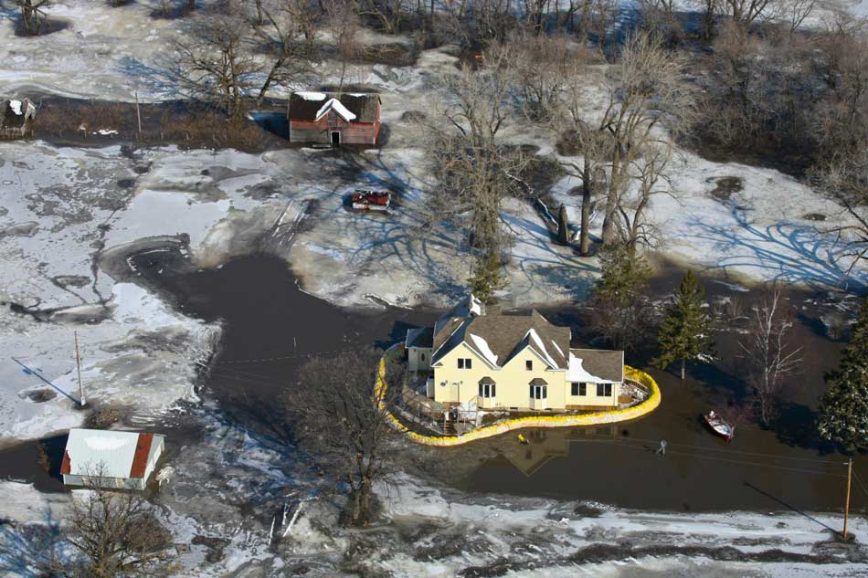
Too Much Too Quickly
A rapid melt at moderate elevation, however, can be a different story. Higher elevations are often remote and the thaw there is likely to be slow and gradual. At lower elevations, more likely to be closer to population centers, the snowpack will be comparatively little. But at moderate altitudes below about 7,000 feet─which can be not far from population centers─snowpack can be deep and easily affected by wide temperature variations. As with other perils, the amount and value of property exposed to this risk is increasing as more homes are built in areas prone to flooding from snowmelt.
A winter of heavy snowfall and accumulation combined with a warm and rainy spring can significantly increase the potential for severe flooding. In a warm spell, large volumes of meltwater can be generated in a short period of time. Like any precipitation, this meltwater may soak into the ground or run off into local streams, rivers, and lakes. But if the ground is still frozen and unable to absorb the liquid, and/or if local drainage systems are quickly overwhelmed, flooding can ensue.
Riverine flooding can be caused or exacerbated during a thaw if broken-up ice is carried downstream and accumulates around obstructions to form ice jams. Small jams can dislodge themselves and flow downstream to contribute to larger jams, sometimes causing flash floods in the process as released water overwhelms watercourses downstream. Ice jams can form quickly, and were estimated by NOAA in 2013 to cost the U.S. about USD 125 million annually. In addition to flooding, rapid snowmelt can trigger landslides and debris flows.
Part of the Picture
Snowmelt is rarely the sole cause of flooding, but it can be an important contributing factor. In the U.S., snowmelt contributes regularly to flooding in many areas, particularly the Northeast, northern Midwest, and some areas in the West. Although snowmelt-related floods are generally localized and less severe than those caused by excessive precipitation, many historical flood events in the United States are associated with snowmelt. Heavy precipitation and snowmelt during the late winter and early spring of 2011, for example, led to massive flooding along the lower Mississippi River, particularly in the states of Arkansas, Kentucky, Louisiana, Mississippi, Missouri, and Tennessee.
The AIR Inland Flood Model for the United States can accurately determine the effects of antecedent soil conditions, precipitation, and snowmelt on the discharges at each river segment across the contiguous U.S. To capture all the complexities inherent in a flood generation process, AIR scientists used the degree-day model, an effective and widely-used snowmelt model. The exacerbating effect of rain falling on accumulated snow (often referred to as the “rain-on-snow” effect) is incorporated by including the heat exchange between rain and snow, using a process similar to that used by the National Weather Service.
In the U.S. generally, 2017 has been a good year for snowpack totals. In the Upper Colorado River Basin, for example, snowpack stood on March 30 at 124.69% of what is considered normal for that date. And, after having been way below-average for several seasons, the Sierra Nevada now has its biggest snowpack for years, standing on March 30 at 175% of the average for the date with more snow forecast for the region. Let’s hope for a mild and dry spring!


