It is well known that the North Atlantic Oscillation (NAO) impacts European winters, primarily with respect to storm activity. NAO-positive (NAO+) phases are often associated with above-average storm counts, as described in a previous AIR Current. But how do other atmospheric signals, such as the East Atlantic Pattern (EA) impact European winter weather?
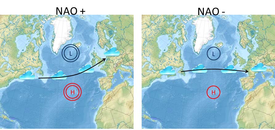
The NAO is characterized by a pressure difference between the Subpolar Low located near Iceland and the Subtropical or Azores High. A positive or negative phase is then related to whether this pressure difference is larger or smaller, respectively, than average (Figure 1).
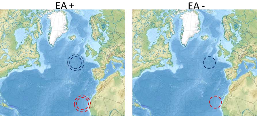
The EA is also a pressure dipole over the Atlantic, but for this mode of variability, the low pressure is located to the west of the UK and the high pressure is southwest of the Canary Islands (Figure 2). The question is: How do these two climate patterns interact with each other and ultimately influence the weather in Europe?
Results from Natasha Denn’s Master’s degree project at the University of Reading (co-supervised by AIR) suggest that the EA and NAO both have an impact on European winter storm activity. The influence can be seen in multiple aspects of the winter season, but the one focused on here is the occurrence of extratropical cyclones (ETCs) during the winter months (October-March inclusive). Research has already shown that both the EA and NAO influence the latitudinal position of the jet stream, which in turn determines where ETCs are steered on their travels into and across Europe. Therefore, it is expected that the NAO and EA will also influence where ETCs impact Europe. Such a result was one of several observed in this MSc project and is summarized in Figure 3. Each arrow in Figure 3 indicates the central axis of the storm track (i.e., the region where the storms mainly travel) for each of the four combinations of NAO and EA phases.
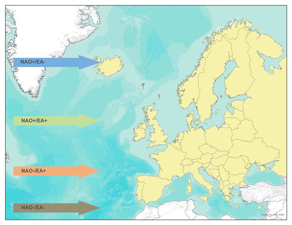
When the NAO is in a positive phase, it can be seen that latitudes north of 50 degrees experience the greatest ETC activity, suggesting a northward shift in where the storms are steered. When the EA is also considered, it can be seen that a positive EA, in conjunction with a positive NAO, coincides with notably higher storm activity in the 50- to 60-degree latitude band. During a negative EA and positive NAO phase, the storms track even farther north, away from some of the peak exposure concentrations in Europe. When the NAO phase is negative, the storms tend to track across more southerly latitudes and have a greater impact through France and central Europe. Once again, the EA amplifies this signal, with a negative EA coinciding with activity farther south.
ETC activity is by no means the only aspect of winter weather that can be analyzed in relation to these two climatic signals, which can also be thought of as “large-scale patterns of variability.” Even with regard to ETCs there are other aspects that can be considered such as how quickly storms intensify and the maximum intensity of the storms during their life span. In the meantime, it is worth noting that while the NAO is an important influence on ETC activity, other climatic signals—such as the EA—should also be considered.
Surely this means we can take these signals into account when forecasting ETC activity for the coming (or current) season, right? Unfortunately, we are not yet able to predict modes of atmospheric variability and forecasters can only produce probabilities for which phase the NAO will be in over a seasonal timescale.1 Also, some work published in 2014 showed a relationship between the EA and sea-surface temperatures in the Indo-Pacific Ocean, indicating some potential forecast skill for this index.2 These two areas of research combined suggest that in the future the ability to forecast with some degree of accuracy and detail the ETC activity over Europe may be possible; however, ETC activity remains to some degree a ‘wait and see’ peril.
1 Seasonal to Decadal Prediction of the Winter North Atlantic Oscillation: Emerging Capability and Future Prospects; D. Smith, A. Scaife, R. Eade, and J. Knight.
2 Seasonal Predictability of the East Atlantic Pattern from Sea Surface Temperatures; I. Iglesias, M. Lorenzo, and J. Taboada.