


Events such as the December 26, 2004, Indian Ocean tsunami and the March 11, 2011, Tohoku tsunami remind us of the ways that tsunamis can drastically alter the environment. Changes to the natural, built, or social environments are not always easy to quantify, however, especially in the case of the most catastrophic tsunami events, whose impacts may be felt for many years to come.
In the risk modeling industry, we aim to capture the complexities that nature presents. It is a challenging task as tsunami risk is not static; tsunami events will not strike a given location the same way in the future as they may have done in the past. An obvious question to ask is, “Why is that?”
Growing Exposure, Changing Geography
Half of the people in the world live on the coastline or within 100 miles of it, and this population is growing. Coastal areas are always changing because of natural processes, such as land subsidence—for example, estuaries silting up—and erosion caused by wave action or storms. Coastal areas also undergo significant transformation due to human activities such as the development of businesses and homes; measures like beach nourishment and seawall construction are intended to protect them.
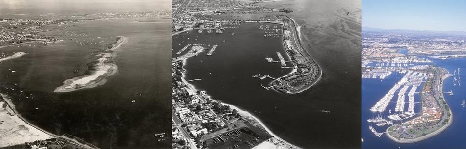
Ports and harbors in particular undergo significant modifications, as redevelopment to enhance facilities and improve operations is quite common. San Diego Bay, for example, is one of the largest harbors on the U.S. West Coast, and it was significantly transformed by development in the 20th century. Modifications decreased the water area by filling in shoals around the main channels to add more land, including the area where Lindbergh Field—now known as San Diego Airport—was built. In a similar vein, Port of the Americas in Ponce, Puerto Rico, is undergoing major transformations and is envisioned to become a major port hub.
What Does This Mean for Tsunamis and Risk?
Development means more exposure in the port facilities and in the nearby businesses and communities that depend on them. It is no easy matter to determine how man-made changes to ports will alter the impact of tsunamis upon them. Each location is different, with a unique combination of topography, bathymetry, infrastructure, property, and development plans. What we do know is that some changes can reduce vulnerability, while others might worsen it.
Historic events teach us about the impact of tsunamis in the past when the coastline and exposure were very different. What happens in the future will depend on how the coastline has been modified and how exposure has changed. For example, the dredging typically done to aid navigation makes wave penetration into ports and harbors easier, and because boat basins usually have relatively narrow openings, they are commonly found to have high tsunami currents. For example, the entrance to the basin formed by Shelter Island in San Diego Harbor—which is now connected to the mainland by an isthmus and enlarged by land reclamation—was subject to high currents in past tsunamis (e.g. the 1960 Chile tsunami and the 2011 Tohoku tsunami). Current bathymetry and topography data in catastrophe models helps to better capture changes in the coastline, while detailed exposure can improve tsunami impact predictions. The more we learn, the more models can improve, and the better you can own your risk.


