A recent survey asked 5,000 adults in the UK to identify the things that make the British unique as a nation. Perhaps unsurprisingly, the most popular trait proved to be "talking about the weather." According to a British Council educational website, weather is a national obsession as conditions are constantly changing. Because it can be so unsettled, many types of weather may be experienced in a single day.
The UK is probably most infamous for its seemingly omnipresent precipitation, hail being just one of the many forms. While the risk of damaging hail in the UK is generally quite low, there have been some severe hail events, including the 2012 East Midlands event with golf-ball-sized, car-damaging hailstones.
When considering hail risk across Europe—or more accurately severe thunderstorm risk (straight-line winds, tornado, and hail)—comprehensive views cannot ignore the UK.
Modeling UK hail risk
Due to the scarcity of information about historical severe thunderstorms in some parts of Europe, a robust view of risk cannot be developed based solely on historical claims data. Fortunately, probabilistic models can be developed and used in concert with meteorological reanalysis data to estimate long-term risk.
Reanalysis data represents the historical state of the atmosphere by bringing together observation data and using modeling techniques to fill in any gaps. Specific meteorological parameters can be extracted from the reanalysis data set and used in a regression analysis to estimate the probability of severe thunderstorm activity on any day in the historical period covered by the reanalyses. The probability of hail activity is dependent on an index—a proxy for the severity of weather—and the type of weather, as follows:
phail = β0 + β1 ∙ SVRI + β2 ∙ WLK
where:
- phail is the probability of hail
- β terms are constants
- SVRI is the Severe Weather Index
- WLK is the weather type
Creating a stochastic catalog
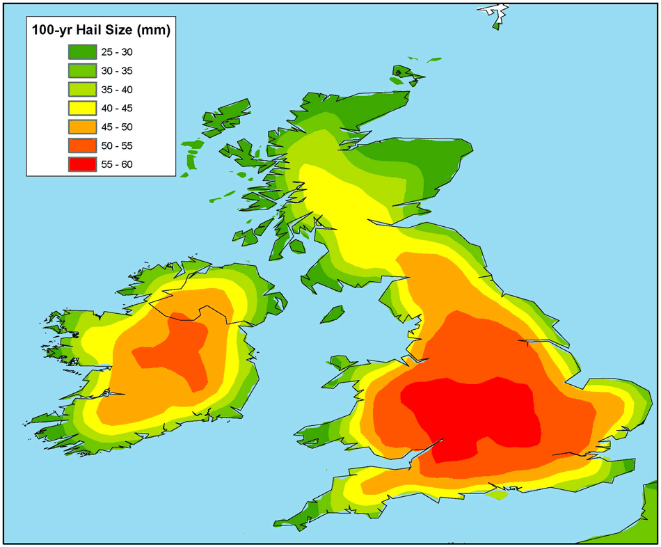
The resulting probability of hail occurrence for every day in the historical period covered can be used to determine the spatial distribution of simulated events, and historical data can be used to determine frequencies, intensities, and footprints, ultimately producing a stochastic catalog that can be used to estimate hail risk in the UK. The following map shows one such view of risk as defined by the 100-year return period hail diameter. As shown in the figure, larger hail seems to occur each year in the western UK, spreading from central England into Wales. A smaller peak also exists in the Republic of Ireland.
Our work on this topic is ongoing and represents just one aspect of AIR's development of a probabilistic European severe thunderstorm model currently scheduled for release in the summer of 2018.