


AIR is developing worldwide flood hazard maps for markets where it is not yet possible to create fully probabilistic flood models (as we've done for the U.S., the UK, and Germany). These maps provide a view of the extent of the flooding associated with river flow magnitudes at the 100-, 250-, and 500-year return periods (1%,0.4%, and 0.2% annual exceedance probabilities) and can be imported as hazard layers into Touchstone® to facilitate efficient accumulations management and underwriting decisions. The first two, released earlier this year, are for Thailand and China.
Elevation data is one of the most important aspects of assessing flood risk because both flood extent and depth are determined by it. For some countries, including the aforementioned U.S., UK, and Germany, high resolution Digital Terrain Models (DTMs) are readily available. But neither China nor Thailand has any publically available DTMs at the country or river basin scale.
What to do?
AIR decided to use a global Digital Elevation Model (DEM) to develop hazard maps for these countries. We considered two commonly used, freely available elevation data sets with sufficient resolution for modeling: the Shuttle Radar Topography Mission (SRTM) DEM and ASTER DEM, with 90 m and 30 m resolution, respectively.
While the ASTER DEM might seem the obvious choice because of its higher resolution, that's not the only consideration when selecting an elevation dataset. Elevation accuracy is also very important.
Because ASTER DEM uses overlapping pairs of satellite images to estimate elevation, atmospheric interference, clouds, sun angle, and other variables can introduce error into the estimates. The SRTM dataset was generated using a synthetic aperture radar (SAR) system mounted on the Space Shuttle Endeavor, and it does not suffer from these limitations; thus it can provide better estimates of the actual elevation.
Let's take a look at the Bangkok area to better understand the differences between ASTER and SRTM.
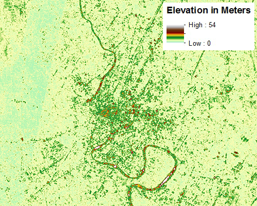
Bangkok, ASTER, 30 m resolution (Source: NASA)
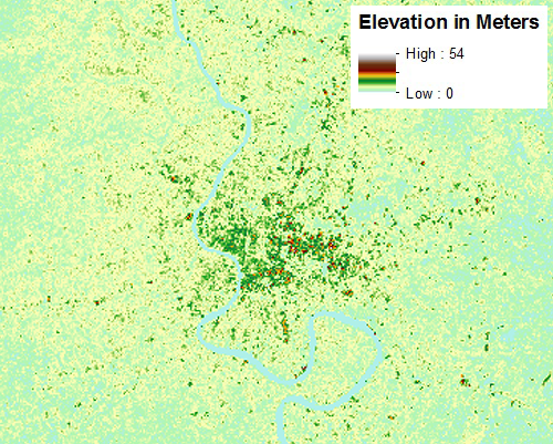
Bangkok, SRTM, 90 m resolution (Source: NASA)
Bangkok is situated in the Chao Phraya River delta in Central Thailand. The land is flat and low-lying, with an average elevation of 1.5 meters (4 ft 11 in) above sea level. Much of the area was swamp before it was drained for agriculture, and city that occupies it today is slowly sinking.
Both ASTER and SRTM reflect Bangkok's geography, but they present slightly different views of the elevation of the river in relation to the city around it. The ASTER DEM dataset depicts the Chao Phraya River as having a higher elevation than much of the city, which is not the case. The SRTM elevation data represents the elevation of the river more accurately, not least because of extensive post-processing by NASA to accurately capture elevations of water features.
In addition to the improved estimation of water feature elevations, the amount of inter pixel elevation variability or "noise" is much lower with SRTM than ASTER. The two graphs below show how much variability there is in the ASTER elevation data, compared with the relatively smooth SRTM elevation data. Furthermore, we can see that ASTER includes the elevations of buildings in its elevation estimates. While SRTM also includes some information on building heights, the magnitude of impact on the elevation estimate is much lower than for ASTER.
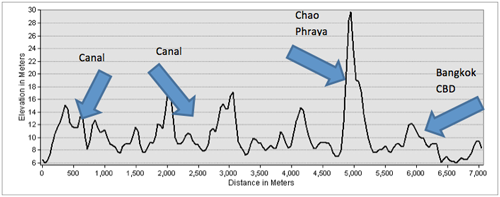
ASTER elevation profile for an 8.5 km east-west elevation profile across Bangkok and the Chao Phraya River
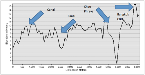
SRTM elevation profile for an 8.5km east-west elevation profile across Bangkok and the Chao Phraya River
As AIR continues to expand the geographic coverage of its flood models, we will continue to seek out the best elevation datasets for inclusion into our models-and into our flood hazard maps. While it's tempting to opt for the highest resolution elevation data, it is even more important to make sure that the data accurately represents all aspects of the terrain to be modeled.
For more information on AIR's flood hazard maps for China and Thailand, read the solutions brief.


