Bermuda lucked out during Gonzalo. Bermuda was right in the center of Gonzalo's eye. Those two statements may seem contradictory, but they're not.
On Friday, October 17, the center of Hurricane Gonzalo's very large 30-mile radius eye passed directly over Bermuda, and its eyewall crossed the island twice. What could be worse, right? But what if Gonzalo had tracked just a little farther west (or east) and Bermuda had experienced the eyewall only once-but had remained in it longer?
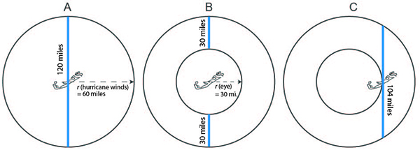
We can start by looking at this from a purely geometric perspective by way of the three scenarios illustrated below. Gonzalo's hurricane force winds as it passed over Bermuda extended out 60 miles from the center of the storm. If Gonzalo had no eye (bear with me), Bermuda would have experienced hurricane force winds for the full 120 miles of Gonzalo's passage over the island. That's scenario A. But in fact, Gonzalo's eye was a whopping 30 miles in radius. Bermuda experienced Gonzalo's eyewall twice, but for a total length of just 60 miles (30 + 30), as illustrated in Scenario B. Had Gonzalo tracked 30 miles further west than it did and subjected Bermuda to uninterrupted hurricane force winds, our geometry exercise shows that Bermuda would have experienced 104 miles of punishment (Scenario C). That's nearly 75% longer than Scenario B!

Gonzalo track scenarios showing (A) path through the center of Bermuda without eye, (B) through the center with 30 mi radius eye, and (C) path shifted west (not to scale)
In AIR's hurricane model, and as evidenced by claims data, the duration of damaging winds is an important variable in determining loss. You can read more about that here. So let's see what the impact of Gonzalo's direct hit on Bermuda has on modeled loss estimates.
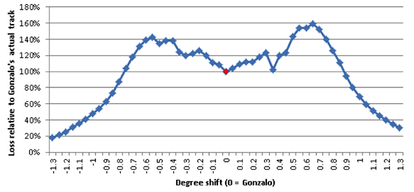
We perform two analyses using the AIR Tropical Cyclone Model for the Caribbean (which happens to include Bermuda). In the first analysis, we've turned off the asymmetry factor of our modeled wind field. (The asymmetry factor captures the exacerbating impact on wind speeds of the rotational direction of hurricane winds and the hurricane's forward speed.) That allows us to isolate the impact on losses of the track position alone-that is, the impact of Bermuda's being in the center of the eye compared to the eyewall. The graph below indicates how modeled losses would change if Gonzalo's actual track (denoted by the little red dot at 0) were shifted east or west. It's relatively symmetrical-any asymmetries are due to the actual distribution of Bermuda's exposures. You'll note that if Bermuda had been in either eyewall, losses would have been higher. The results reveal the impact on losses of the duration of damaging winds.

Modeled losses as a function of track location, without asymmetry
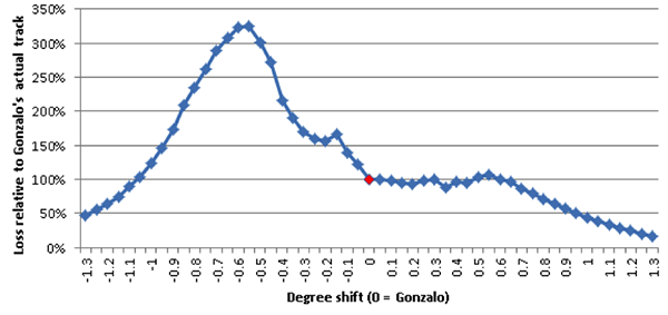
For the second analysis, we use the release version of the model-that is, with the asymmetry factor of the wind field turned back on. As expected, if the track had been shifted westward (-0.5 degrees in the graph below), the losses would have been significantly higher due to both the longer duration of damaging winds discussed above and to putting Bermuda through the front right quadrant of the storm, where the wind speed of the hurricane vortex is compounded by its forward progress along the path-the area with the highest winds.
It is interesting to note that if the storm had been shifted eastward (0.5 degrees in the graph below), and the left eyewall had passed over the island, losses would have been about the same as the actual Gonzalo. Although the duration of damaging winds would have been longer, the maximum sustained winds would have been lower.

The AIR model's results (i.e.,with asymmetry) for various track positions
On a final note, Hurricane Fabian, which impacted Bermuda back in 2003, passed just west of the island, putting the longest duration and strongest winds directly over the exposures. If Gonzalo had taken a track just 20-30 miles further west than it did, damage would have been much more severe and losses higher.
