


Preview of the 2019 Atlantic Hurricane Season
Jun 24, 2019
Editor's Note: The Atlantic hurricane seasons of 2017 and 2018 brought record-breaking hurricanes. In this article, we discuss what the forecasting agencies are projecting for this year, how reliable those forecasts are, and what factors can influence seasonal activity and potential losses.
The Atlantic hurricane season produced record-setting storms in the last two years, with 2017 producing Harvey, Irma, and Maria, and 2018 producing Florence and Michael. Here are a few of the records last year’s hurricane season set:
- In mid-September during Hurricane Florence, a reporting station in Swansboro, North Carolina, measured 34 inches of rain and another in Elizabethtown, North Carolina, measured 35.93 inches, breaking the North Carolina record set by Hurricane Floyd in September 1999 of 24.06 inches.
- Hurricane Michael’s minimum central pressure decreased to 919 mb—the third-lowest pressure on record for a U.S.-landfalling hurricane—as it rapidly approached the coast of Florida in mid-October.
- Michael was reanalyzed by the National Hurricane Center, which announced on April 19 that the storm’s estimated intensity at landfall was 160 mph, or a Category 5 storm—only the fourth Category 5 storm officially on record to have struck the United States.
The last two Atlantic hurricane seasons have certainly made their mark, prompting many to wonder what this year will bring.
Pre-Season Forecasts
The official North Atlantic hurricane season runs from June 1 to November 30, although storms can—and have—occurred outside that window. An average season will see approximately 12 named storms, of which six will reach hurricane strength and three will become major hurricanes (i.e., a Category 3–5 on the Saffir-Simpson scale), according to the National Oceanic and Atmospheric Administration (NOAA).
This year’s pre-season forecasts are predicting slightly above-average activity for the 2019 Atlantic hurricane season (Table 1).
| Source | Named Storms | Hurricanes | Major Hurricanes |
|---|---|---|---|
| NOAA | 9–15 | 4–8 | 2–4 |
| University College London | 12 | 6 | 2 |
| Colorado State University | 13 | 6 | 2 |
| Weather.com | 14 | 7 | 3 |
| North Carolina State University | 13–16 | 5–7 | 2–3 |
| AccuWeather | 12–14 | 5–7 | 2–4 |
| Climatological Average (NOAA) | 12 | 6 | 3 |
Competing Climate Signals
Most organizations and agencies that issue hurricane season forecasts account for well-known climate signals linked to tropical cyclone activity. These signals provide insight into the potential enhancement or suppression of activity for a given season. The two most important climate signals linked to seasonal activity are the phase of the El Niño-Southern Oscillation (ENSO) and Atlantic sea surface temperatures (SSTs), which this year are in competition with each other in terms of impact on Atlantic hurricane activity. While the current El Niño phase of ENSO, increases vertical wind shear and suppresses tropical cyclone formation, the forecast warm SSTs in the Atlantic generally contribute to tropical cyclone formation.
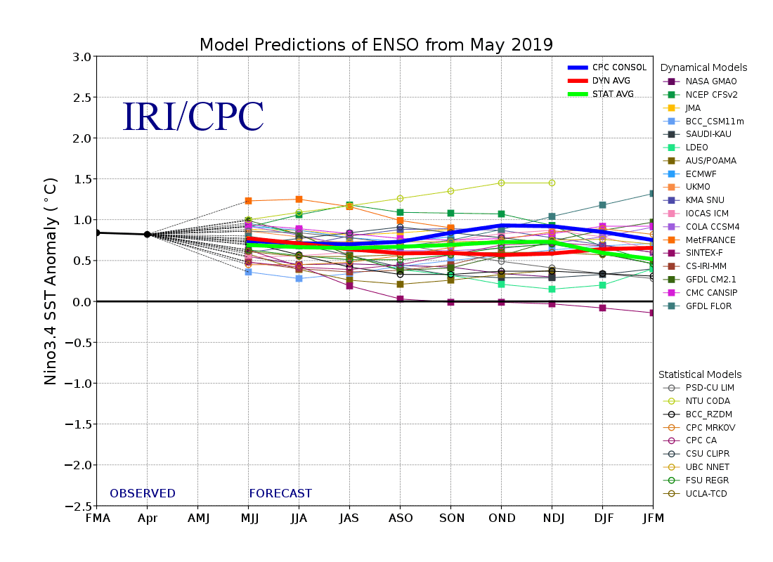
ENSO is described by the National Oceanic and Atmospheric Administration (NOAA) as “a recurring climate pattern involving changes in the temperature of waters in the central and eastern tropical Pacific Ocean.” Depending on its phase, ENSO can either foster or hinder hurricane development. In an El Niño phase, SSTs increase in the eastern tropical Pacific, which in turn increases the intensity of the vertical wind shear over the tropical Atlantic—conditions that can inhibit tropical cyclone formation in the Atlantic. The La Niña phase is associated with cooler SSTs in the eastern tropical Pacific and less vertical wind shear in the Atlantic, which would otherwise hinder tropical disturbances from developing into hurricanes. A weak El Niño (SST anomaly < +1°C) was in place at the beginning of this year and is forecast to persist throughout the season (Figure 1).
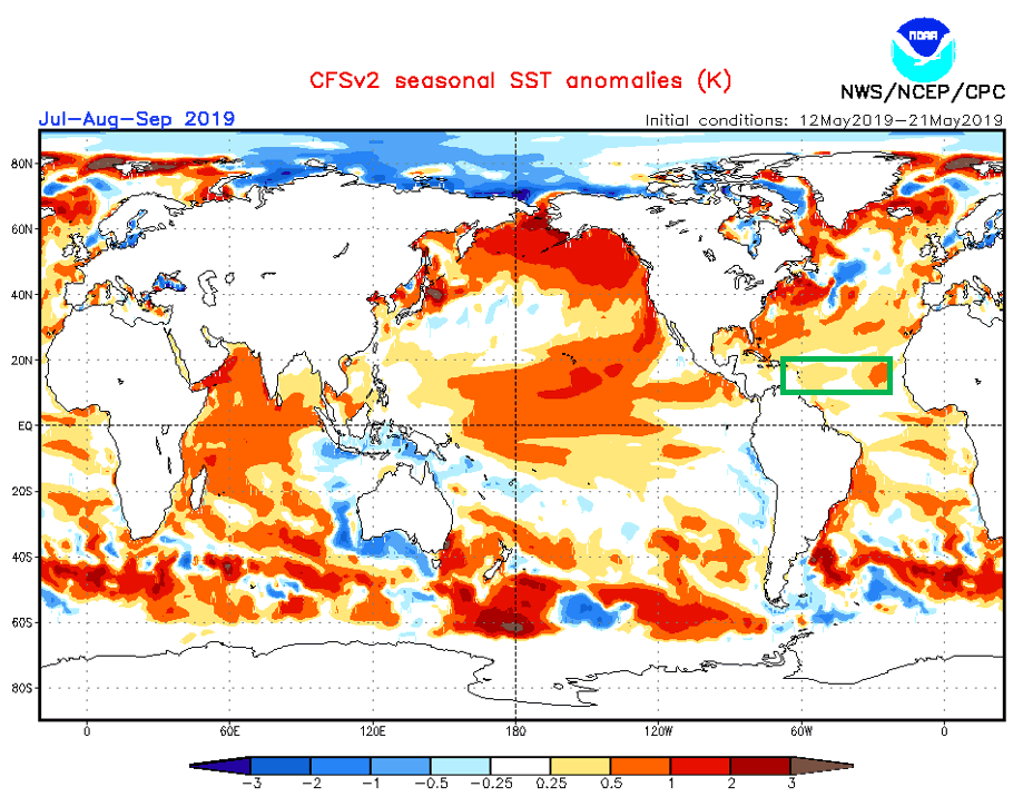
Competing with the inhibiting effect of El Niño are the forecast warmer-than-average SSTs in the tropical Atlantic—specifically in the Main Development Region (MDR), where most tropical cyclone formation occurs during the peak of hurricane season. Warm SSTs can fuel tropical cyclone formation and intensification. Figure 2 shows the mean SST anomaly forecast for the months of July, August, and September.
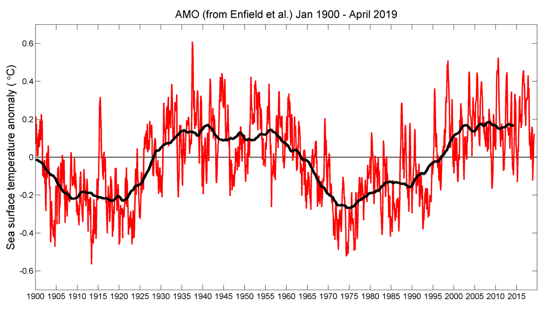
Atlantic SSTs are impacted by the Atlantic Multidecadal Oscillation (AMO), a natural variability of SST and sea-level pressure fields in the North Atlantic (0–70°N). While ENSO changes phase every 3 to 7 years, a phase of the AMO typically lasts about 30 years. Figure 3 shows the month-to-month variability in sea surface temperature anomaly within the region the AMO phase is determined, which is the difference from the long-term average (from 1900 to the present). The current warm phase began in the mid-1990s with no indicative decreasing trend. This oscillation determines the overall trend in Atlantic SSTs, although variations over shorter periods can—and do—occur; for example, changes in atmospheric composition, such as the presence of volcanic ash and desert dust, can block short-wave radiation from reaching the surface, thereby impacting SSTs.
Thanks to these competing climate signals, which have inherent uncertainty within their own forecasts, making exact predictions for the season is difficult; shorter-term factors add to that uncertainty.
NAO, MJO, and Other Shorter-Term Factors that Add Uncertainty
Unlike the AMO and ENSO, which can take decades or years to change phase, respectively, there are shorter-term factors that can change on a monthly or even weekly basis and further contribute to uncertainty. Because these weather phenomena cycle over such short time periods, they cannot tell us much about an entire season in advance. Instead, they should be monitored throughout the season and seen as factors that can influence a tropical cyclone’s genesis or track.
The North Atlantic Oscillation (NAO) Index, for example, is based on the difference in sea-level pressure between the sub-polar low and the subtropical high, and it exhibits both inter-annual and inter-seasonal variability. Depending on the phase of the NAO, a zone of high pressure known as the Bermuda High (during the boreal summer and fall) shifts location. This influences the large-scale steering flow, which can cause hurricanes to veer and change the location of landfall or recurve out to sea. In practice, the difficult-to-forecast NAO index is only predictable around two weeks in advance.
Another oscillation that varies on a relatively short time scale is the Madden-Julian Oscillation (MJO)—an eastward-moving disturbance of clouds, rainfall, winds, and pressure in the tropics that circumnavigates the globe—which can complete an entire cycle within 30 to 60 days. The MJO phase, determined by the location of enhanced precipitation and its intensity, can elevate the probability of tropical cyclone genesis in the Gulf of Mexico and the Caribbean Sea; its short cycle, however, makes using it for tropical cyclone seasonal forecasts inherently uncertain.
In addition to the oscillations mentioned above, there are other factors that can influence hurricane activity in the Atlantic. The Saharan Air Layer (SAL), for example, is a mass of warm, dusty, dry air that propagates from the Saharan Desert westward across the Atlantic during the summer and fall in the Northern Hemisphere and can fluctuate in a matter of days. It can inhibit tropical cyclone formation by stripping the air of moisture, reducing instability, and enhancing vertical wind shear—all of which hinder cyclogenesis. While there are agencies that provide SAL forecasts, SAL characteristics can change quickly and this phenomenon’s presence and intensity over the Atlantic is unpredictable.
Slower Storms, More Precipitation
A recent climatological study revealed that tropical cyclone motion is slowing, allowing storms to spend more time over a given location and increasing localized rainfall. The decreasing forward speed of tropical cyclones over the last several decades is believed to be linked to our changing climate. As the poles are warming faster than the tropics, the average pole-to-equator temperature difference is decreasing and large-scale weather systems are slowing down in response. In addition, our warmer climate has led to warmer air that can hold more water vapor—7% more per degree warmer (Celsius)—which contributes to increased precipitation.
The combination of slower movement and increased precipitation contribute to severe flooding, as was the case with Hurricane Harvey (2017) and Hurricane Florence (2018). The longer storms take to move across an area, the greater the opportunity for them to cause both wind damage and flooding. Will 2019 be the third year in a row that produces a hurricane that causes record precipitation and flooding? We shall see.
It Only Takes One
Although the forecasts are calling for a slightly above-average season, these projections include a good amount of uncertainty. It’s also important to remember that a season does not have to be very active for it to have a major impact; in fact, it only takes one storm to make landfall or even closely bypass the coast to cause significant insured losses, as we have seen.
Pre-season forecasts can provide a general sense of what may occur, but we cannot know exactly what to expect in advance. We don’t know if this season will bring further hurricane losses, but we do know that such an outcome is possible.
Probabilistic models remain the most reliable method of obtaining a comprehensive view of tropical cyclone risk. They incorporate a full range of physically possible storms and help companies prepare for the unexpected—an especially important risk management practice given the uncertainty in pre-season forecasts. Storms such as last year’s Florence and Michael, for example, are accounted for in the stochastic catalog of the AIR Hurricane Model for the United States, which insurers can leverage to accurately price hurricane risk, design incentives to strengthen the resilience of homes and businesses, and evaluate the efficacy of different risk mitigation strategies. Anticipated for release next year, the updated AIR Hurricane Model for the United States will incorporate enhanced modeling capabilities for inland flooding caused by hurricane-related precipitation to help companies better understand and manage all the drivers of their U.S. hurricane risk.
 Michal Clavner, Ph.D.
Scientist II
Edited by Rachel Wisch, CEEM
The article:
• Forecasts for the 2019 Atlantic hurricane season project slightly above-average activity, but competing climate signals of a warm ENSO (El Niño) phase and warmer-than-average Atlantic sea surface temperatures add uncertainty.
• Additional signals that can vary over weeks or days further enhance the uncertainty of pre-season forecasts.
• It only takes one significant landfalling storm to cause catastrophic losses, so it is best to prepare.
