


The Quake that Moved Mt. Everest: AIR’s Damage Survey in Nepal
Jul 22, 2015
Editor's Note: On April 25, 2015, Nepal was hit by a devastating M7.8 earthquake, the strongest in 80 years. Seventeen days later, an M7.3 aftershock shook the already reeling nation. AIR joined the Earthquake Engineering Field Investigation Team to conduct damage surveys and assess the impacts of these catastrophic events.
Introduction
Earlier this year, Nepal was hit by a historic one-two punch when the most powerful earthquake in 80 years—strong enough to have moved Mt. Everest more than one inch1—was followed less than three weeks later by a devastating aftershock. While the locations of these catastrophic tectonic shifts were within a known fault zone, there had been no seismic activity of a similar nature in that segment since 1934.
The M7.8 mainshock struck at 6:11 UTC on April 25, approximately 34 km from Lamjung. It occurred at an estimated depth of just 10 km, making this a shallow and therefore extremely destructive event. Footage taken in the server room of our sister company Verisk Health’s Kathmandu office offers dramatic testament to the earthquake’s effects; note the synchronized acceleration measurements, which were recorded at a site approximately 610 meters west of the building. The building experienced minor damage but remained structurally sound.
 Suryanarayana Datla
AVP and Director
Edited by Rachel Wisch
The article:
- The strongest earthquake to hit the region in 80 years devastated Nepal on April 25, followed by a powerful aftershock on May 12.
- The most severe damage was observed to older unreinforced masonry structures with weak mortar, while concrete-framed buildings and those with earthquake mitigation features fared better.
- The path to recovery will be challenging, and rebuilding efforts should be undertaken with future risk mitigation in mind.
Less than one month after the mainshock, an M7.3 aftershock dealt the nation a further blow. Rescue and relief efforts from the primary earthquake were halted due to transportation disruptions, structures that were already weakened on April 25 collapsed, and the death toll from both events rose to more than 8,5002—the highest on record for the country.
Survey Findings
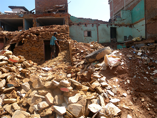
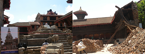
A few weeks after the large aftershock, AIR joined the Earthquake Engineering Field Investigation Team (EEFIT) to conduct on-site damage surveys. The team comprised seismologists, geologists, geotechnical, and structural engineers from both academia and the insurance industry. The first town visited was Chautara in the district of Sindhupalchowk, which is approximately 80 km from Kathmandu. The team observed extensive damage there, as most unreinforced stone masonry buildings with clay/cement mortar had collapsed (Figure 1).
There was also severe damage to the concrete-framed structures in Chautara, most of which can be attributed to sloped terrain ground failure or foundation failure (Figure 2).
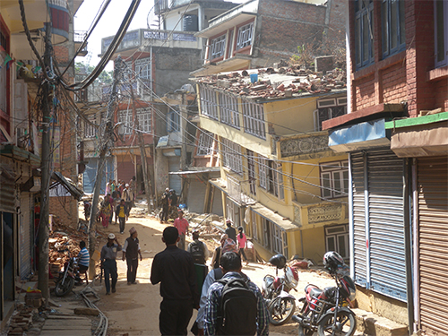
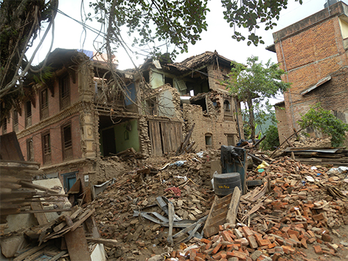
In the city of Kathmandu, the team observed clusters of damage to old and weak houses constructed of unreinforced stone or brick with clay or cement mortar. In most cases, the damage was the result of soft-story or foundation failure (Figure 3).
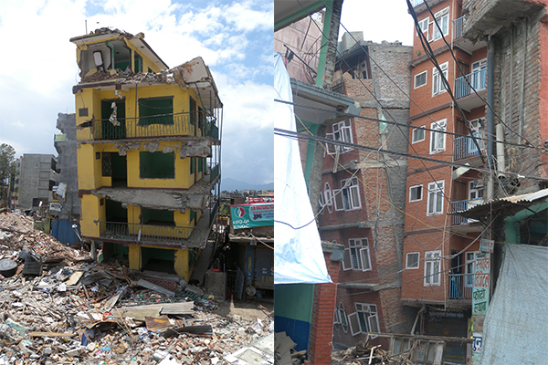
In the industrial portion of the city, damage levels varied. Most industrial buildings and warehouses fared well, although there were minor cracks on the masonry infill walls of concrete-framed buildings and minor damage to elevated water tanks. However, the Bank of Kathmandu suffered a complete collapse (Figure 4).
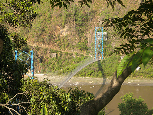
While traveling to Gorkha, located northwest of Kathmandu and close to the epicenter of the earthquake, the team found that many bridges remained intact, keeping some mountain communities connected after the earthquake (Figure 5).
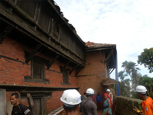
Impacts of the earthquake within Gorkha were visible, though not nearly as severe as observed in Chaukura. Some concrete buildings, including a school, suffered minor damage, as did Gorkha Palace (Figure 6).
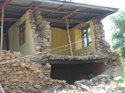
Residential buildings in remote villages and mountain communities closer to the epicenter suffered considerable damage. These were built primarily of unreinforced stone masonry with clay mortar. While some remained standing, a few were red-tagged (deemed unsafe), and others had completely collapsed (Figures 7 and 8).
The team came across many collapsed and damaged residential buildings in the older parts of Bhaktapur, a UNESCO World Heritage Site about 13 km from Kathmandu. Known for its palace courtyards, temples, and statuary, some Bhaktapur landmarks suffered total collapse (Figure 9). Buildings with concrete frames and brick infill fared better.
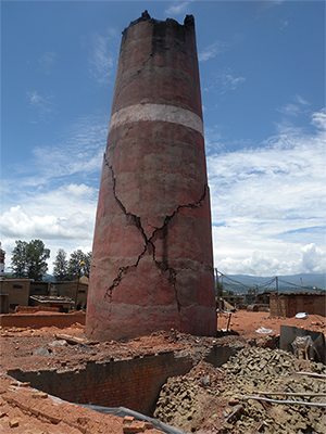
A brick factory located just outside of Bhaktapur sustained visible damage to its kiln chimney (Figure 10). The brick industry is essential for Nepal rebuilding; with fewer operational brick factories and a diminished workforce, it is expected that the price of brick will increase.
In the northwest corner of Kathmandu Valley, approximately 17 km from the capital city, field investigations revealed two main types of construction in the village of Sankhu: unreinforced masonry and confined masonry. Unreinforced masonry structures sustained significant damage or total collapse (Figure 11), while confined masonry structures fared much better.
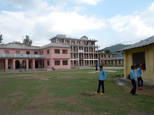
Sankhu is also home to the Sankhu Palubari Community School, which consists of multiple structures with varied constructions and earthquake mitigation features, including old buildings without mitigation features, old buildings with mitigation features, retrofitted buildings, and new buildings without mitigation features. Of these, the retrofitted buildings and buildings with earthquake mitigation features sustained no damage and received green tags, deeming them “fit to use” (Figure 12). It is interesting to note the newest building on campus, constructed five years ago without mitigation features, sustained the heaviest damage.
In general, buildings in Nepal performed as engineers would expect from an event of this magnitude. The unreinforced masonry buildings prevalent in the country suffered extensive damage, as they lack the lateral support needed to withstand strong earthquake ground motion. Somewhat surprisingly, the reinforced concrete building stock performed better than expected—a finding that will warrant further investigation.
Locked and Loaded
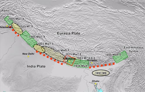
Both the primary earthquake and the May 12 aftershock occurred in the Main Himalaya Thrust fault zone (MHT), which lies along the plate boundary zone between the India and Eurasia plates. This plate boundary is the largest continental collision zone on earth, absorbing about half of the 4.5 cm/year convergence rate between these plates within the 2500 km-wide Himalayas. The April 25 earthquake and May 12 aftershock both occurred along the central segment of MHT in central Nepal, the seismically most active fault segment of MHT. Earlier large historical earthquakes took place in this same segment in 1505 and 1833.
Despite these two recent major seismic events, and the hundreds of smaller aftershocks in the same source zone, the MHT likely remains locked. The repeat occurrence of large earthquakes along this fault indicates that it is essentially stuck due to frictional resistance between the India and Eurasia tectonic plates. Such faults can remain locked for extended periods, releasing small amounts of stored energy through each earthquake instance. The magnitude of the April 25 earthquake was less than would have been necessary to release all the seismic energy that had accumulated in Nepal’s seismic gap. This means the type of aftershock experienced on May 12 was not entirely unexpected, but also that the MHT is poised for future ruptures of large magnitude with increased probability of occurrence in the seismic gap that last ruptured in 1505 (Figure 13).
The Road to Recovery
Work has already begun to rebuild Nepal with an emphasis on prevention. The field investigation team met with various local experts, organizations, and dignitaries to better understand rescue and rehabilitation operations. The National Engineering Association (NEA) rallied 3,500 volunteers to provide visual assessment services for building owners. They have conducted 60,000 surveys thus far. In and around Kathmandu, 199 of the 200 school buildings retrofitted by the National Society for Earthquake Technology (NSET) and GeoHazards International (GHI) saw no damage after the April 25 earthquake: 12,000 more buildings are to be demolished and reconstructed, and another 50,000 will be retrofitted within 12-15 years.
To fully assess the extent of the damage and recovery efforts required, the Nepalese government conducted a Post-Disaster Needs Assessment (PDNA) to estimate overall relief and rebuilding needs for different sectors.3 In addition to outlining steps for immediate recuperation, emphasis is placed on disaster risk reduction (DRR) through better construction and increased public awareness.
Although Nepal is in the most seismically active segment of the MHT and these catastrophic events resulted in massive damage, the impacts on the insurance industry have been minimal. Earthquake is typically covered under fire policies, but insurance penetration is exceedingly low. Policies are typically purchased to fulfill loan contingencies, and most of the risk is passed by insurers to the reinsurance market.
According to Nepal’s National Seismological Center, the April 25 earthquake is the first major seismic event in the region to have been captured by recording instruments. Researchers, including those at AIR, have much to learn from this event from a seismological, engineering, and risk mitigation point of view.
For more information about the EEFIT damage survey, visit the team blog here.
