


Preview of the 2015 Atlantic Hurricane Season
Jun 24, 2015
Editor's Note: The current nine-year stretch without a major hurricane landfall in the U.S. is the longest in recorded history, and warm East Pacific sea surface temperatures suggesting a high likelihood of El Niño are furthering speculations that this lull may continue. Seasonal forecasting, however, is inherently uncertain, meaning that from a loss standpoint, anything is possible.
Introduction
The media is abuzz about this year's Atlantic hurricane season, largely due to the record-breaking nine-year stretch without a major (Category 3 or higher) hurricane landfall in the United States. Hurricane Wilma, which struck Florida as a Category 3 storm in October 2005 after pummeling Mexico's Yucatán Peninsula, was the most recent. The subsequent "drought" is the longest since record-keeping began in 1851; the previous record of eight years occurred in 1861–1868.1
Meteorologists and weather agencies around the world are fueling the fire with forecasts of a below-average season, which officially runs from June 1 to November 30. In this article, we'll examine the 2015 forecasts, the climate factors considered in their creation, and the inherent uncertainty associated with both. No matter how this season shapes up, AIR can help you stay apprised of the latest developments and mitigate your risk.
Forecast Building Blocks
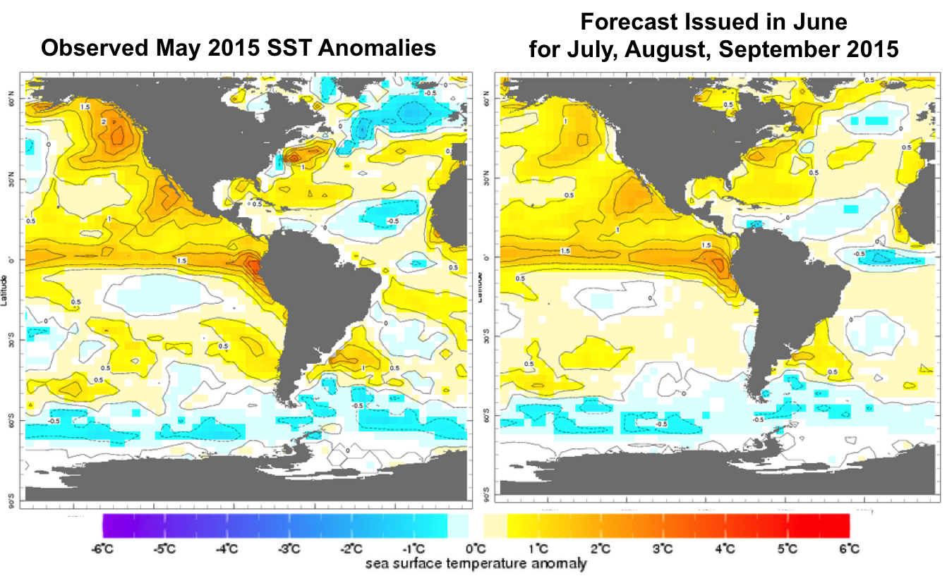
A number of climate factors are individually assessed by meteorologists to build predictions of the hurricane season. Chief among these factors are sea surface temperatures (SSTs) and wind shear conditions, which are somewhat predictable in advance, although the uncertainty rises significantly with increasing lead times. Storms need an ample supply of energy to form and strengthen, and humidity from warm SSTs provides that energy. In the Atlantic, while there were some pockets of warm SST anomalies in April, the expectation is for the conditions to be very close to normal across the Atlantic later in the season (see Figure 1).
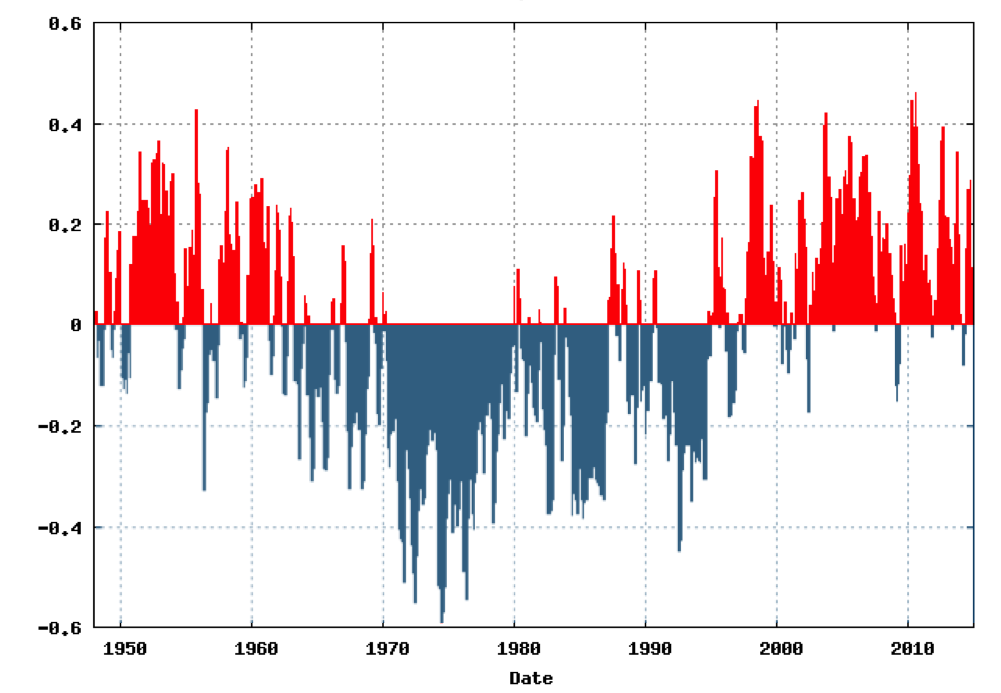
The Atlantic SSTs are closely tied to a mode of variability called the Atlantic Multidecadal Oscillation (AMO) that has been the source of some very warm Atlantic SSTs in recent seasons. We know that a greater percentage of tropical storms mature into hurricanes and major hurricanes during AMO warm periods. Our current warm period, as shown in Figure 2, seems to contradict the SST forecast of neutrality, but there have been other times in the recent past when cold anomalies have temporarily popped up. While we do not yet know if this indicates the end of the warm phase, it is worth monitoring.
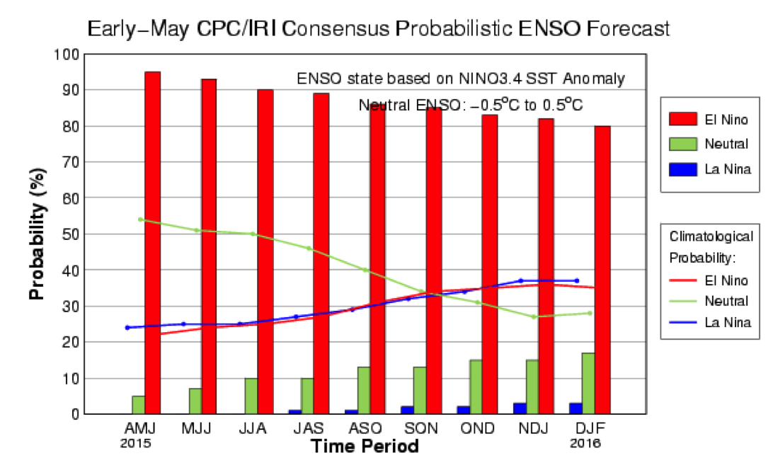
In the East Pacific, warm SSTs create a series of complex weather phenomena known as El Niño, while cool SSTs create La Niña. There is a direct correlation between El Niño in the Pacific and increased wind shear in the Atlantic. So even if perfect SST and AMO conditions exist for hurricane formation, atmospheric wind shear could snuff out a potential storm before it has a chance to form.
Based on the current and forecast East Pacific SSTs, the Climate Prediction Center (CPC) and International Research Institute for Climate and Society (IRI) have released their 2015 predictions for El Niño/La Niña (Figure 4). As of early May, their confidence in El Niño was close to 85% by the core of the season. While not completely impossible, the chances of conditions reversing into La Niña are akin to the Cubs and the Red Sox playing in the World Series this year (that is, near nil, for those of you who are not conversant with America's favorite pastime). However, the 15% chance of neutral (or La Niña) conditions is not insignificant. Case in point: last season began with similar expectations, but El Niño conditions never materialized.
 Dr. Tim Doggett
AVP, Senior Principal Scientist
Edited by Rachel Wisch
The article:
- The United States is in the midst of the longest major hurricane landfall drought in recorded history.
- Forecasters are predicting a quiet season and banking on El Niño conditions, but many other important factors that will shape the season cannot be predicted in advance.
- Forecasts are highly uncertain, and even inactive seasons can produce storms that cause catastrophic losses.
A Quiet Hurricane Season: To Be, Or Not To Be?
Using the forecast building blocks, which create a foundation that can only be described as shaky at best, agencies around the world release their predictions for the upcoming hurricane season. Some of the more well-known forecasting agency's predictions are presented in Table 1.
| Agency | Forecast Date | Named Storms | Hurricanes | Major Hurricanes |
|---|---|---|---|---|
| Tropical Storm Risk | May 27 | 10 | 4 | 1 |
| Colorado State University | June 1 | 8 | 3 | 1 |
| North Carolina State University | April 13 | 5 (Range of 4–6) |
2 (Range of 1–3) |
1 |
| UK Met Office | May 21 | 8 (Range of 6–10) |
5 (Range of 3–7) |
NA |
| WSI/Weather Channel | April 21 | 9 | 5 | 1 |
| NOAA | May 27 | 8.5 (Range of 6–11) |
4.5 (Range of 3–6) |
1 (Range of 0–2) |
| AccuWeather | May 18 | 8 | 4 | 1 |
| Consensus | 8.1 | 3.9 | 1 |
Not surprisingly, the expected number of named storms for the 2015 Atlantic hurricane season varies, and some organizations provide ranges, demonstrating the characteristic uncertainty in hurricane forecasting. Nevertheless, trends can be identified within the data, especially when compared to historical averages.
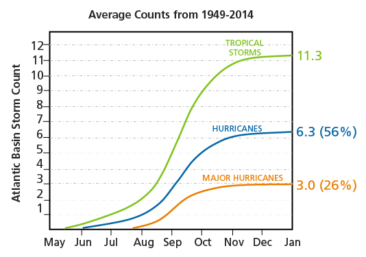
All of the released 2015 prediction figures are lower than the seasonal averages in Figure 4. This, however, is merely a numbers game. While these forecasts can provide an indication of activity in the upcoming season, they are based on only a handful of the myriad elements that can influence how a season actually progresses, none of which can be predicted with certainty. In addition, not one of these forecasts addresses what ultimately causes losses: where hurricane landfalls may occur, which is impossible to predict in advance of storm formation.
Effective risk management requires a probabilistic assessment of potential losses, and this is the role of catastrophe models.
Tools for a New Season
As tropical systems develop throughout the season, AIR will closely monitor their progress and provide real-time updates should they threaten to impact land in the form of NewsALERTs. Additional details and post-event analyses from both a hazard and engineering point of view are often available in AIR Currents, CATWeek, and webinars.
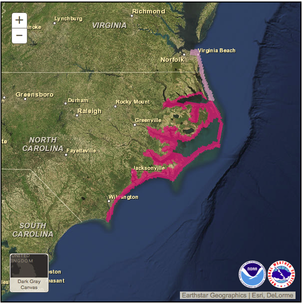
The National Hurricane Center (NHC) is offering a new tool this year, issuing storm surge warnings with a prototype warning/watch graphic (Figure 5).2
While these tools provide value for storms in real time, proactive risk management—independent of how any one season shapes up—requires taking a probabilistic view. AIR's U.S. hurricane model provides two catalogs for more comprehensive risk assessment: the standard catalog based on all historical seasons, and the warm SST catalog, which is conditioned on historical seasons with anomalously warm SSTs and reflects a typical warm Atlantic season. New to our hurricane model this year is an updated storm surge module, which accounts for spatial and temporal meteorological information, localized topographical and mitigation details, exposure location and construction data, and policy specifics to produce robust and highly granular insured loss estimates. Also new this year is our Canada tropical cyclone model, released this year as one of our three new or updated Canada atmospheric models.
Conclusion
Forecasters are calling for another mild season this year, suggesting that the major hurricane landfall drought may persist through the 2015 hurricane season. However, even if no major hurricane strikes this year, the possibility of high losses from less intense storms must be considered. Sandy caused upwards of USD 18.8 billion in insured losses when it struck New Jersey in 2012, according to PCS®.3 And even during very inactive seasons, all it takes is one destructive storm to cause monumental destruction and losses. In 1992, forecasters expected a mild season due to El Niño conditions, and indeed only four hurricanes formed that year. One of the four, however, was Hurricane Andrew, which forever reshaped the insurance risk management landscape.
Due to the intrinsic uncertainty in the multiple layers of a forecast, they have limited application from a risk management perspective. Still, seasonal forecasts can be useful if handled with the proper care: They may suggest what a season might hold—but no guarantees.
