


Still Risky But Better Prepared—10 Years After the 2004 Sumatra Tsunami
Dec 18, 2014
Editor's Note: Although the likelihood of an earthquake and tsunami like the 2004 Sumatra event in the Indian Ocean was well recognized, the level of destruction and number of casualties was unprecedented. The absence of a tsunami warning system contributed to the magnitude of the disaster, as did the local building stock. Could such an event strike again? And is the region better prepared now?
The Indian Ocean region was ripe for disaster December 26, 2004, when the powerful Sumatra-Andaman earthquake struck 100 km off the west coast of the Indonesian island of Sumatra. The magnitude 9.1 megathrust earthquake was one of the strongest in the last century and generated a devastating and far-reaching tsunami.
Is the worst yet to come? Read about what may be in store for the island of Java.
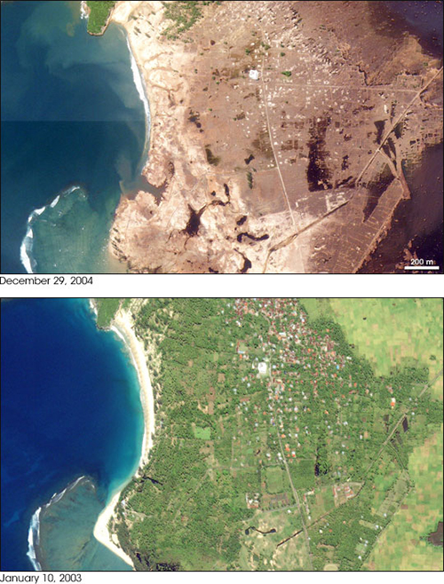
Low-lying coastal communities and fishing villages in the nearby region—such as Banda Aceh, the capital of the Sumatra province of Aceh—were no match for the walls of water as high as 30 meters that raced to shore, some within minutes of the earthquake (Cluff, 2007); nor were the hundreds of thousands of people killed, with little or no warning and no escape. Property damage was massive, and often complete. The tsunami was so immense in some locations that coastal land area was reshaped, subsided, or removed (see Figure 1).
Countries around the Indian Ocean and well beyond were affected by the Sumatra tsunami (also referred to as the 2004 Indian Ocean tsunami, South Asian tsunami, Indonesian tsunami, Christmas tsunami, and Boxing Day tsunami), although Indonesia, Sri Lanka, India, and Thailand felt the brunt. Structures unfortified against the force and inundation of tsunami floodwaters were simply swept away, like the tide washing over a sand castle. In total, nearly 230,000 people lost their lives, and approximately 1.7 million survivors were displaced and left homeless, according to the United States Geological Survey (USGS).
The risk of high-magnitude earthquakes in this seismologically active region remains, of course, but in the decade since the Sumatra-Andaman earthquake and resultant tsunami, resilience to natural disaster has been improved, notably through the implementation of a tsunami warning system for the Indian Ocean. In addition, advancements in catastrophe modeling are expanding our understanding of the frequency, intensity, and potential damage from earthquake-generated tsunamis. Nevertheless, a decade after what has been called the worst natural disaster in recorded history, two salient questions remain: What is the risk of another magnitude 9 earthquake striking the region? If a similar tsunami recurred, would the impact be as dire?
 By: Dr. Bingming Shen-Tu
Assistant Vice President, Senior Principal Scientist
 By: Daniel Edson
Senior Writer
Edited by Nan Ma, CCM
Article Highlights:
- The 2004 M9.1 Sumatra-Andaman earthquake generated a tsunami that ranks as the deadliest in recorded history.
- The new Indian Ocean Tsunami Warning System (IOTWS) can transmit alerts in less than 10 minutes.
- A repeat event should be less deadly, but its location would strongly influence insured loss potential.
- AIR's Southeast Asia earthquake model is being expanded with a fully probabilistic tsunami model.
Seismology Shifts and Debatable Risk
What is the risk of another magnitude 9 earthquake striking the region?
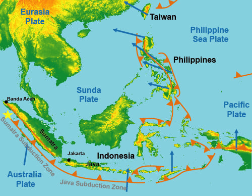
Indonesia sits along the Pacific Ring of Fire, the seismically active fault line known for producing some of the strongest earthquakes in history. The devastating December 26, 2004, M9.1 Sumatra-Andaman earthquake occurred in the Sumatra subduction zone in the Sunda Trench, which roughly parallels the western side of the Indonesian island of Sumatra.
No stranger to strong earthquakes, the Sunda Trench has been the site of a string of powerful events in the last couple of hundred years, including an M8.4 earthquake in 1797, M8.8-9.2 in 1833, and M8.3-8.5 in 1861. These events ruptured the entire plate interface of the central segments of the Sumatra subduction zone.
The 2004 Sumatra-Andaman earthquake—with a rupture line longer than 1,000 km and more than 100 km wide according to the USGS—ruptured the northern segment, releasing seismic energy built up over the last few centuries. Subsequent earthquakes in the Sunda Trench—including an M8.7 event in 2005, M8.4 in 2007, M7.6 in 2009, and M8.4 in 2012—further relieved tectonic pressure, thus lessening, to some degree at least, the likelihood of an earthquake of the magnitude of the 2004 Sumatra-Andaman earthquake in the near term.
A reduced risk in the fault system off the west coast of Sumatra, however, does not eliminate the chance of an equally powerful earthquake striking elsewhere in the domain in the foreseeable future. The Java subduction zone, for example, a 1000-km continuation of the Sunda Trench that roughly parallels the southern shore of the Indonesian island of Java, has been seismically quiet compared to the Sumatra subduction zone, with no earthquakes larger than M8 in more than two centuries. Because of this lack of historical seismicity, many seismologists have considered this subduction zone to be aseismic, or very lowly coupled along the subduction zone fault. Yet with a convergence rate of 6 to 7 cm per year, tectonic stress in the Java subduction zone can accumulate as fast as or even faster than in the Sumatra subduction zone, if the subduction zone fault is highly coupled (locked). Some recent GPS survey results do indicate that the subduction zone fault in the Java subduction zone could be locked, at least along some portion of the trench. Therefore, with the occurrence of the 2004 Sumatra-Andaman earthquake and the 2011 M9.0 Tohoku earthquake in Japan, many experts—including those who considered the Java subduction zone to be nearly aseismic—now believe that the possibility of a similar giant earthquake cannot be ruled out. If a similar earthquake occurred, it would not only impact Java Island, which is more densely populated than Sumatra, but also coastal cities surrounding the Indian Ocean, including in Australia.
Consequently, another massive earthquake could occur in the region, although where and when is both debatable and debated. Redistributed stresses can shorten time between events in some areas, while lengthening time in others.
Tsunami Warning System Improves Survivability and Resilience
If a similar tsunami occurred today, would the impact be as dire?
The loss of life and destruction would depend on the location of the earthquake generating the tsunami. An earthquake in the Java subduction zone could have greater impact than one in the Sumatra subduction zone because of the socioeconomic differences between the islands of Java and Sumatra. Java is more densely populated and wealthier than Sumatra, with a more robust infrastructure and more exposure at risk—including upscale hotels, shopping malls, and other tourist-oriented facilities. Insurance penetration is also higher on Java (the 2004 event did not result in high insured losses because it largely affected areas with low insurance take-up).
The overall risk of death and property damage from a tsunami in the Indonesia domain has changed substantially, however, since the Sumatra-Andaman earthquake and Sumatra tsunami killed hundreds of thousands and erased whole communities from the land. In 2004, Indian Ocean nations lacked a tsunami warning system, leaving vulnerable coastal residents and many thousands of visitors little if any time to react to an approaching tsunami wave or to sea recession (which often precedes a wave striking shore).
Within weeks after the tragic 2004 event, the Intergovernmental Oceanographic Commission of the United Nations Education, Scientific, and Cultural Organization (UNESCO) began organizing a multinational initiative to develop a tsunami warning system for the Indian Ocean. Less than two years after the 2004 event, the Indian Ocean Tsunami Warning System (IOTWS) was capable of transmitting tsunamogenic earthquake advisories.
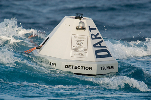
The IOTWS, which involves nearly 30 countries, became fully operational in March 2013, with 25 seismographic stations and 6 Deep-Ocean Assessment and Reporting of Tsunami (DART) buoys for sensor data, coordinated by the NOAA Pacific Tsunami Warning Center in Hawaii (see Figure 3). In addition, the IOTWS receives data from the Commission for the Nuclear-Test Ban Treaty Organization seismographic stations.
Events in the last few years have demonstrated the potential effectiveness of the system. After the 2006 M7.7 Pangandaran earthquake in the Java subduction zone, tsunami warnings were transmitted to the Indonesian government, although systems were not yet in place to notify people on the coast. When an M8.9 earthquake struck Banda Aceh in 2012, the initial alerts went out 5 minutes after the event, and the India Regional Tsunami Service Provider transmitted a bulletin in 8 minutes, both meeting the IOTWS performance standard of 10 minutes.
Importantly, education and preparedness, which can play a major role in reducing both loss of life and property damage from a tsunami, are key components of IOTWS. With advance warnings via text messages, radio, television, sirens, and loudspeakers, people in the path of a tsunami not only have a greater chance of survival, they also have a better opportunity to secure property, notably marine facilities and vessels. In addition, residents and property owners in the region are now more cognizant today than a decade ago of the very real likelihood of a tsunami and how to respond to a tsunami threat. They are also more aware of the value of construction techniques and materials that can help mitigate the effects of both earthquake shaking and tsunami waves, although implementing better building standards has been a challenge (see the box, "Construction Improvements—Slow and Unsteady Progress").
Because of the IOTWS, an event similar to the 2004 Sumatra tsunami would likely be less deadly today, although whether it originates from the Sumatra subduction zone or the Java subduction zone would affect its damage and insured loss potential.
Improving Earthquake and Tsunami Modeling
The December 2004 Sumatra-Andaman earthquake and resulting tsunami was one of the deadliest natural disasters in recorded history. While the event did not result in substantial insured losses, it highlighted the very real risk that the region faces—including nearby areas with higher insured exposure. Since then, scientists, engineers, disaster planners, and a wide range of local and international agencies, have been working to improve the region's ability to prepare for, respond to, and rebuild after the next major earthquake.
A key part of this effort is improving the understanding of seismic risk and the impact of potential tsunamis. AIR is developing a comprehensive update to the AIR Earthquake Model for Southeast Asia, which currently covers Indonesia, the Philippines, and Taiwan, and will be expanded to include Hong Kong, Macau, Singapore, and Vietnam. In addition to reflecting the latest view of seismic hazard, building vulnerability, and industry exposure and policy conditions, the upcoming model will feature a fully probabilistic tsunami model for Indonesia and the Philippines, a capability that AIR first introduced to the industry in 2013 for Japan.
AIR's tsunami model is capable of capturing the complex science of tsunami development, tsunami behavior as it nears the coast and then comes ashore, and the dynamic rerouting of water—including changes in wave height and inundation extent related to water velocity—as the tsunami water and exposure interact. The vulnerability component of the AIR tsunami model accounts for inundation depth, water velocity, and debris, as well as the effect and possible failure of flood defenses, such as seawalls and levees. Tsunami damage functions cover all lines of business, including marine hull and cargo.
Advanced catastrophe models give risk managers the ability to examine and plan for a full range of large loss scenarios and to assess the potential tsunami damage from earthquakes of a variety of magnitudes and in a variety of locations.
Boen, Teddy, 2006. "Observed Reconstruction of Houses in Aceh Seven Months after the Great Sumatra Earthquake and Indian Ocean Tsunami of December 2004," Earthquake Spectra, Volume 22, No. S3, pages S803-S818 (June).
Cluff, Lloyd S., 2007. "Effects of the 2004 Sumatra-Andaman Earthquake and Indian Ocean Tsunami in Aceh Province," The Bridge vol. 37, no. 1(National Academy of Engineering): https://www.nae.edu/Publications/Bridge/EngineeringfortheThreatofNaturalDisasters/Effectsofthe2004Sumatra-AndamanEarthquakeandIndianOceanTsunamiinAcehProvince.aspx (accessed December 12, 2014).
Okazaki, K., et al., 2015. "Learning on the Safety Issues of Reconstructed Houses from the 2004 Great Indian Ocean Earthquake and Tsunami in Aceh, Indonesia," Recovery from the Indian Ocean Tsunami: A 10-Year Journey, chapter 17 (Springer, Japan).
Rofi, Abdur, Shannon Doocy, and Courtland Robinson, 2006. "Tsunami Mortality and Displacement in Aceh Province, Indonesia," Disasters, 30(3): 340-350: https://jhu.pure.elsevier.com/en/publications/tsunami-mortality-and-displacement-in-aceh-province-indonesia-5 (accessed December 16, 2014).
