


Assessing the Threat of Earthquake-Triggered Landslides in Canada
May 27, 2014
Editor's Note: Earthquakes frequently give rise to landslides that can threaten life and property. In this article, we introduce AIR's newly-developed approach to modeling earthquake-triggered landslides and explore a hypothetical earthquake scenario for Canada that triggers damaging regional landslides.
Earthquake-triggered landslides can destroy buildings and vital infrastructure. Although most earthquake damage is directly caused by ground shaking, in some rare cases earthquake-induced landslides result in the majority of the total damage and fatalities. The devastating avalanche triggered by the May 31, 1970, M7.9 Rio Santa earthquake in Peru—which buried thousands of buildings, destroyed local transportation and utility systems, and killed more than 18,000 people (Keefer 2002)—is an extreme example of the property damage and loss of life that earthquake-triggered landslides can inflict.
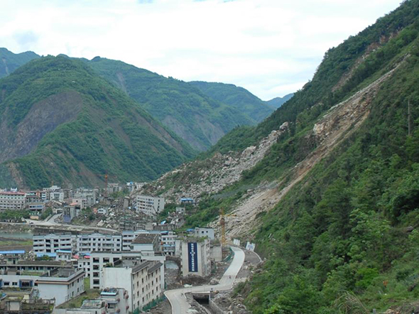
The extensive landslides associated with the M7.9 2008 Wenchuan, China, earthquake also underscore how severe this peril can be. With its epicenter in the mountainous western portion of Sichuan province, this powerful earthquake triggered an estimated 56,000 rockfalls and landslides. While many of these were small, some were not, including the Guantan landslide, which displaced over 4 million cubic meters of rock (Huang et al. 2013). In Beichuan county, a landslide destroyed a middle school, killing over 700 students (Zhang 2009). Other landslides triggered buried homes, damaged roads and railroads, and in some cases dammed rivers, further threatening local communities with flooding (EERI 2008).
 By: Dr. Mesut Turel
Engineer, Research & Modeling
 By: Dr. Molly J. Markey
Science/Technical Writer
Edited by Nan Ma
The article: Introduces the new landslide component of the updated AIR Earthquake Model for Canada (slated for release in July 2014), describes historical earthquake-triggered landslides and their effects, and presents an overview of a hypothetical earthquake that triggers landslides in the Vancouver region of Canada.
Highlights: The AIR method for modeling earthquake-triggered landslides uses digital elevation data, geological maps, seasonal precipitation amounts, and assessments of slope stability to estimate regional landslide susceptibility. While not a major contributor to overall earthquake risk in Canada, the landslide peril can nevertheless pose a significant threat.
Parts of Canada Exhibit Elevated Landslide Risk
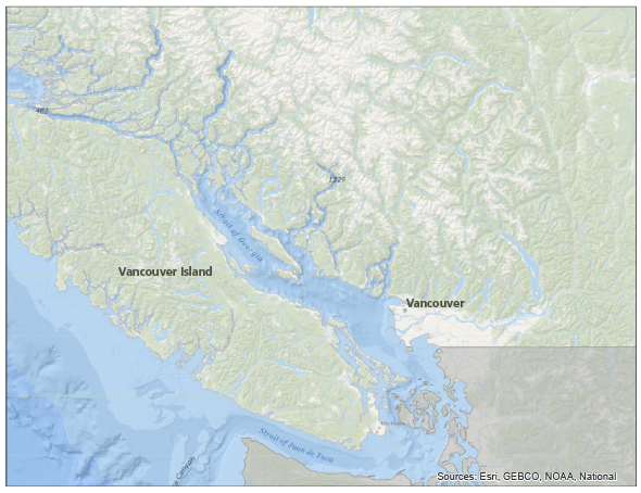
Certain regions of Canada are notably susceptible to landslides. The Coast Mountains, for example, which stretch from Vancouver to the Alaskan border, elevate the region's landslide hazard (see Figure 2). The 1985 Nahanni earthquakes triggered massive landslides in the Northwest Territories (Cassidy et al. 2010). While sparsely populated, these landslide-prone regions are home to vital infrastructure, such as highways, rail lines, power lines, and pipelines, increasing the potential damage that this peril could inflict on western Canada.
But landslide risk is not confined to these western regions of Canada. In fact, geological data indicate that earthquakes spawned by fault slip in eastern Canada have produced earthflows and landslides across the Ottawa valley (Aylsworth 2000).
The AIR Approach to Modeling Earthquake-Triggered Landslides
The updated AIR Earthquake Model for Canada explicitly models earthquake-triggered landslides and their financial consequences. The likelihood of a region experiencing landslides during earthquake ground shaking depends on the severity of the ground shaking and on several characteristics of the region, including slope steepness, slope material properties, and water saturation of the soil. AIR accounts for each of these characteristics to produce a regional landslide risk model for Canada. While the landslide model was developed for Canada, it can be applied to other geographic regions for which the necessary input data are available.
These input data include high-resolution digital elevation models (DEM) for calculating slope angles. Surficial and bedrock geological maps are also needed to identify the rock and sediment types—the material properties—that form the slopes. (A slope composed of strong materials, such as the intrusive igneous rock granite, or a well-cemented sedimentary rock, such as sandstone, is less likely to experience landslides than an equally steep slope made of weaker rocks or sediments, such as shales or sandy soils.) Published relationships among slope angle, slope material properties, and soil water saturation are used to create landslide susceptibility maps. These susceptibility maps are a critical first step toward an accurate estimation of possible landslide damage. To account for seasonal precipitation changes, landslide susceptibility is determined separately for wet conditions and for dry conditions.
Figure 3 illustrates how landslide susceptibility was derived for the Greater Vancouver region of Canada. As would be expected, the figure shows that landslide susceptibility is highest in regions with rugged topography and that this effect is magnified when the soils are water-saturated.
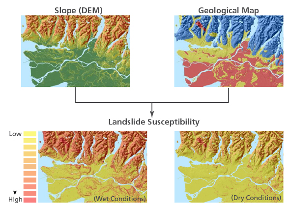
The landslide susceptibility of the Greater Vancouver region is also shown interactively in the embedded video. Areas of highest landslide risk are depicted in red.
Each landslide-susceptibility category has a critical acceleration, a minimum value that if met or exceeded by the ground acceleration during an earthquake would cause a landslide. AIR's damage functions relate the severity of the landslide (as captured by permanent ground displacement) to damage to buildings, contents, and automobiles, following a process published by HAZUS in 2012. While these damage functions were originally produced by AIR for Canada, they can be modified for other regions at risk to earthquake-triggered landslides.
A Hypothetical Earthquake and Its Regional Landslides in British Columbia
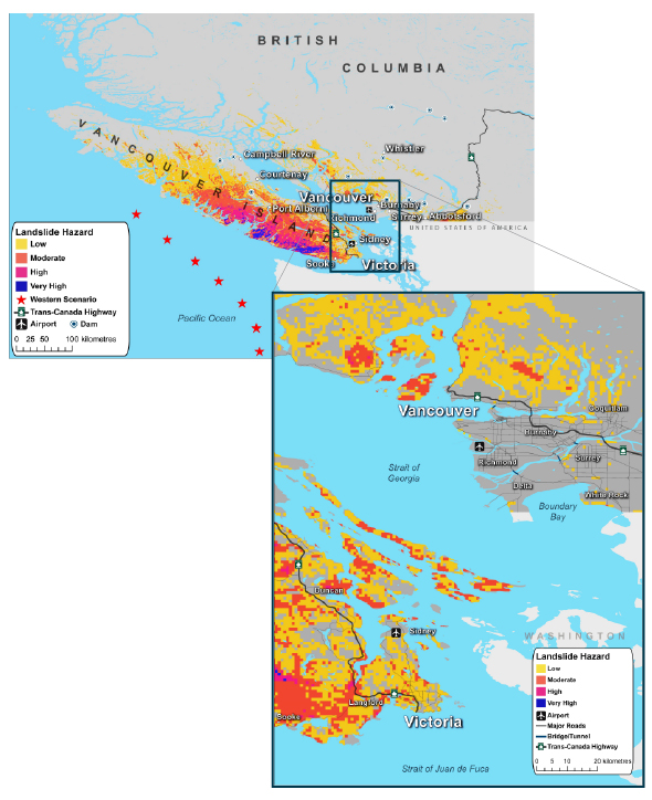
To illustrate the utility of AIR's new earthquake-triggered landslide model for Canada, we examine the landslide hazard associated with a hypothetical earthquake occurring in the Cascadia subduction zone, approximately 75 km (47 miles) off the west coast of Vancouver Island. At M9.0 and a shallow focal depth of just 11 km (7 miles), this powerful earthquake would result in strong ground shaking throughout Vancouver Island and the Greater Vancouver metropolitan area, which includes regions with elevated landslide susceptibility.
While ground shaking would cause the majority of damage and loss from this event, earthquake-triggered landslides also would disrupt economic activity and restrict access to the region. On the west coast of Vancouver Island are large areas at moderate risk of landslide, with additional areas of high risk to the north of Tofino; this event is therefore anticipated to trigger landslides in these regions. Because there is relatively little exposure here—small towns such as Tofino and Ucluelet are characteristic of this portion of Vancouver Island—insured losses would be small. However, the airport at Tofino would likely experience moderate to extensive damage from ground shaking, tsunami, and landslides, putting this transportation center out of service for several weeks.
Conclusions
While ground shaking is typically the dominant driver of loss during earthquakes, landslides are a regionally important hazard that not only can inflict direct damage on homes and businesses, but also can have a significant impact on roads, bridges, water supplies and sewage systems, and other infrastructure assets.
Most residential policies do not cover damage from landslides (and landslide coverage is typically excluded from earthquake policies), but some homeowners may be able to obtain separate earth-movement coverage to protect against this peril. Insured risk is currently predominantly limited to commercial and industrial lines. With increased awareness of earthquake risk in Canada, demand for landslide coverage may well increase. The AIR model is the first to provide a comprehensive assessment of risk and loss from all earthquake-related perils, including ground shaking, tsunami, liquefaction, landslide, and fire following earthquake. Its high geographical resolution enables granular risk differentiation that can help companies develop innovative ways to meet evolving needs in the industry.
Aylsworth, J.M., D. E. Lawrence, J. Guertin 2000, "Did two massive earthquakes in the Holocene induce widespread landsliding and near-surface deformation in part of the Ottawa Valley, Canada?" Geology, 28, 903-906.
Cassidy, J.F., G. C. Rogers, M. Lamontagne, S. Halchuk, J. Adams 2010, "Canada's Earthquakes: 'The good, the bad, and the ugly,'" Geoscience Canada, 37, 1-16.
Earthquake Engineering Research Institute (EERI) 2008, "The Wenchuan, Sichuan Province, China, Earthquake of May 12, 2008," EERI Special Earthquake Report — October 2008.
Huang, R., J. Zhao, N. Ju, G. Li, M. Lee, and Y. Li. 2013. "Analysis of an anti-dip landslide triggered by the 2008 Wenchuaj earthquake in China," Natural Hazards, 68: 1021-1039.
Keefer, D. K. 2002. "Investigating landslides caused by earthquakes — a historical review," Surveys in Geophysics, 23: 473-510.
National Research Council 2004. Partnerships for Reducing Landslide Risk: Assessment of the National Landslide Hazards Mitigation Strategy, National Research Council of the National Academies. 127 pp.
Zhang, L. 2009, "Challenges in multi-hazard risk assessment and management: Geohazard chain in Beichuan Town caused by Great Wenchuan Earthquake," p. 237-244 in Geotechnical Risk and Safety: Proceedings of the 2nd International Symposium, Edited by Y. Honjo, M. Suzuki, T. Hara, and F. Zhang. 453 pp.
