Fifty years ago today marks a major turning point toward a better understanding of not only earthquakes, but also the large-scale motions of Earth's lithosphere.
The huge magnitude 9.2 Great Alaska Earthquake of March 27,1964, brought seismic hazard to public attention and generated scientific and engineering research that has since saved lives and property. Today, several federal programs-including the National Earthquake Hazards Reduction Program and NOAA's around-the-clock National Tsunami Warning Center-are legacies of this earthquake.

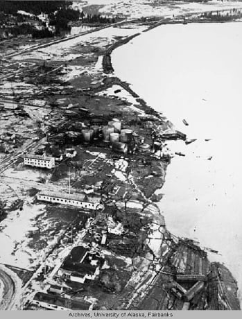
Aerial view of damage to Seward, Alaska (Source: U.S. Air Force)
The Great Alaska Earthquake remains the strongest recorded earthquake to strike North America, and it is the world's second strongest (after the 1960 M9.5 quake that struck Chile). The epicenter was 75 miles east of Anchorage in the Prince William Sound. The rupture originated at a depth of 15.5 miles, and the fault rupture plane extended 500 miles long and 125 mile wide. The sea floor rose 36 feet in some places, while the shoreline dropped well below sea level, submerging forests. The ground shook for 4½minutes.
The tsunami this quake generated was a monster, traveling across the Pacific to affect twenty countries and causing damage as faraway as Japan. Gigantic waves were generated locally, with the maximum wave run-up height recorded in Valdez, Alaska at truly staggering 220 feet! Most of the 131 deaths from this disaster were caused by the effects of ocean waves-with people drowning as far away as Crescent City, California. In Alaska, the earthquake caused liquefaction and led to landslides, mainly in the Anchorage area. Fires broke out from broken gas lines and explosions at a fuel tank depot after a 30-foot wave struck Seward, Alaska.
In the early 1960s, the theory of plate tectonics was gaining credence with geoscientists, but it was still not well-known outside scientific circles. Even for those who studied the theory, movements of the earth's rigid tectonic plates were not well understood. The area impacted by the Great Alaska Earthquake became their classroom.
Geologist Dr. George Plafker was among the group of USGS scientists immediately deployed to study the area impacted by the quake, but there were no faults at the surface to study. Months were spent puzzling over the earthquake's source, until Plafker began to study the quake through the lens of plate tectonics. His research led to the understanding that subduction of oceanic plates below continental plates is a fundamental geological process, and he later termed the Great Alaska Earthquake a "megathrust earthquake." We now view subduction zones as one of many boundaries where the interaction of plates serves as an engine for strain accumulation and catastrophic earthquakes.
The burning question at the time was: How common are megathrust earthquakes in Alaska? After studying cycles of ground uplift and subsidence recorded in sediment deposits, the USGS team found evidence of nine megathrust earthquakes that struck the area during the 5,600 years preceding the 1964 event, with an average interval of about 600 years between each one. Other studies find an average interval between great earthquakes of 535 to 800 years. At the time of the Great Alaska quake, only two seismometers were in place in Alaska. Now there are more than 400, and we know that Alaska has about 24,000 earthquakes on average every year-most of them small magnitude (M2.0 to M3.0)-with at least one M7.0 or larger.
Given Alaska's strategic importance in the Cold War, the U.S. government and the U.S. Army Corps of Engineers worked feverishly to reconstruct south central Alaska-where roughly two-thirds of Alaska's population lived and most of the state's infrastructure was situated-before winter arrived. President Lyndon B. Johnson convened his cabinet to form the Federal Reconstruction and Development Commission for Alaska to upgrade facility standards and give due attention to mitigation. Johnson also requested that the National Academy of Sciences establish the Committee on the Alaska Earthquake, which led to significant documentation and study of this quake, addressing the damage, social and economic impacts, more stringent construction codes, and larger scientific questions raised by the catastrophe.
Today we recognize the enormous contribution the study of the Great Alaska Earthquake made to the field of seismology and to the eventual creation of national programs to protect lives and property from seismic hazards.
