On Friday, November 30, 2018, a major earthquake shook Anchorage, Alaska, at 8:29 a.m. local time. It had a moment magnitude of 7.0 and occurred as the result of normal faulting at a depth of about 44 km (27 miles) about 12 km (7 miles) north of downtown Anchorage, according to the USGS. The USGS has since noted more than 1,000 aftershocks rattling the region, but only 14 were Mw 4.5 or higher and the largest—an Mw 5.7—occurred a few minutes after the main event.
There were no reports of serious injuries or deaths, and the level of damage in Anchorage was relatively minor, considering the magnitude of the earthquake. This has been puzzling for some people who are not very familiar with the physics of earthquakes and the behavior of buildings during seismic shaking. So, let’s review damage reports and then dig into why an Mw7.0 earthquake so close to Anchorage caused only minor structural damage.
Reported Damage
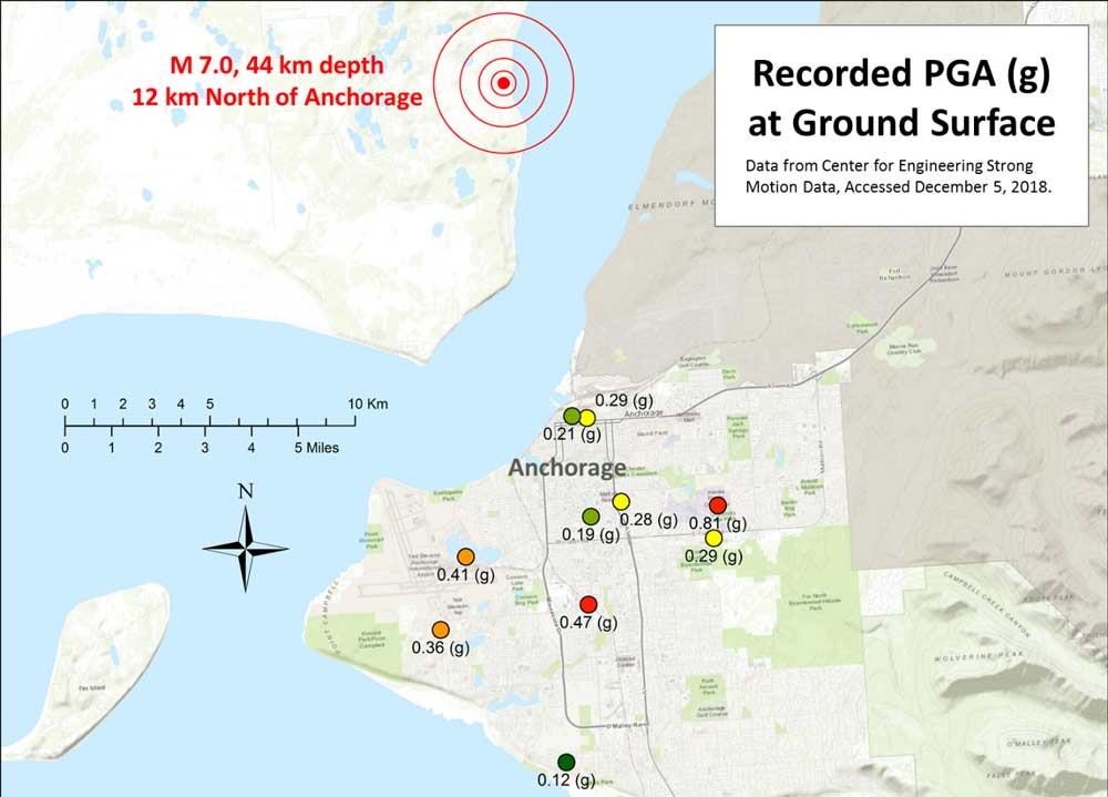
The earthquake shook the Anchorage area severely for less than 20 seconds. Figure 1 shows the location of seismic stations and the recorded peak ground acceleration (PGA) for the main shock across Anchorage. The maximum recorded PGA was 0.81 (g), which is very violent shaking, but for the most part the city experienced PGA ranging between 0.2 and 0.4 (g). This level of shaking is perceived by people standing outside as strong to violent.
Around Anchorage several road sections collapsed completely, while many other sections showed cracks and will have to be evaluated for safety and repairs. Traffic lights were shaken to the ground and vehicles were caused to crash. Damage to the columns and beams of buildings was minor but broken windows were common in many places, and damage to building contents was substantial. All across the city ceiling tiles fell and suspended lights proved perilous. In several cases, sprinkler systems were damaged and flooded buildings, causing serious damage to furniture, electronics, and equipment. Most stores saw products fall off shelves, and at least one fire has been attributed to this earthquake.
Electrical service was temporarily disrupted for thousands of customers. There were reports of damage to power lines and repairs and restoration continued throughout the weekend, but there was no major outage. Reports indicate that by Friday night most customers had electricity. Anchorage Water and Wastewater Utility reported several main line water breaks and issued a boil water advisory. The 1,300-km (800-mile) Trans-Alaska Pipeline was suspended for only a few hours.
Minor damage to the passenger terminal of Anchorage International Airport (the second busiest air-cargo airport in the U.S.) disrupted passenger traffic considerably, but caused relatively minor impact on the cargo throughput, according to initial reports. The port of Anchorage, a critical transportation infrastructure, was fully functional three days after the quake, after officials had completed a survey of facilities.
Focal Depth
The main danger from an earthquake is ground shaking. The ground motions on the Earth’s surface are caused by seismic waves generated due to fault rupture. Seismic waves transmit tectonic energy through the earth at speeds up to several miles per second.
Seismic waves are similar to sound waves: the closer you stand to an audio speaker the louder you’ll hear it; the closer a location is to the earthquake source, the higher the energy received and greater the likelihood of damage.
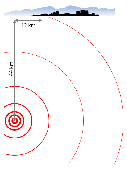
The distance from an earthquake source is determined by the distance to the epicenter and focal depth. Figure 2 illustrates the focal depth and epicenter distance to Anchorage and shows how earthquake depth increases the distance from the energy source. In general (but not always), deeper earthquakes are less damaging because more of their energy dissipates before they reach the surface; greater focal depth implies more decay in ground motion. If the same earthquake had occurred closer to the ground surface, the level of shaking would have been much higher and the damage possibly greater.
Adoption and Enforcement of Stringent Building Codes
Buildings in Alaska were not required to incorporate earthquake resistant design features until the City of Anchorage adopted the 1950 Uniform Building Code (UBC). In spite of the seismic design requirements of the 1950 code, many concrete and steel buildings in Anchorage were damaged by the devastating Mw 9.2 Great Alaska Earthquake of 1964 . Based on the lessons learned, the 1973 UBC adopted by the State of Alaska addressed some of the deficiencies and significantly increased seismic design requirements for southern Alaska. The state of Alaska adopted International Building Codes (IBC) upon their introduction. The current building code is IBC 2012, which was adopted in May 2017.
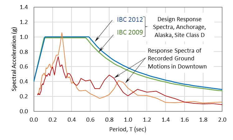
Evidence shows negligible to very minor structural damage due to ground shaking to residential and commercial buildings, bridges, and infrastructure in Anchorage. Most of Anchorage is classified as “Stiff Soil” (NEHRP site class D), turning to “Very Dense Soil or Soft Rock” (NEHRP site class C) toward elevated areas in the east. Figure 3 shows the design spectral accelerations for a typical site in Anchorage, Alaska, based on the current and previous building codes. The response spectra calculated from recorded ground motions at a station located in the Hilton Hotel in downtown Anchorage are shown for comparison on the same plot. The plotted response spectra are for two perpendicular horizontal directions. The recent building codes require that buildings be designed for relatively large accelerations. The demand (i.e., due to real ground shaking) is lower than the capacity (i.e., designed based on design accelerations). Therefore, despite the strong ground motion felt across the region, structures survived well, indicating the effectiveness of building codes.
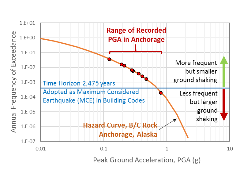
In the IBC codes, design accelerations are derived from Maximum Considered Earthquake (MCE), which approximately corresponds to a hazard level with a 2% probability of exceedance in 50 years (~2,500-year return period). A hazard curve, which is a plot of the annual frequency of exceedance versus peak ground acceleration for Anchorage, Alaska, is shown in Figure 4. Recorded PGA at the 10 stations shown in Figure 1 is also plotted on the hazard curve. Except for the largest PGA, the recorded PGA for this earthquake did not exceed the MCE level. This is an indication that the stringent design requirements of the building codes worked when they were put to the test during a real earthquake.
Better Prepared
There’s no doubt that effective building codes boost resilience. We blogged recently about how of a home in Mexico Beach, Florida, built to withstand much higher wind speeds than the most recent building codes prescribed, survived Hurricane Michael. A few years back, a colleague of mine blogged about how the government responded to the 1964 M9.2 earthquake in Alaska by upgrading standards and giving more attention to mitigation. She recognized the enormous contribution the study of the Great Alaska Earthquake made to the field of seismology and to the eventual creation of national programs to protect lives and property from seismic hazards. More than 50 years later, the November 30 earthquake demonstrated that the measures taken after the 1964 earthquake to improve understanding of the seismic hazard and develop, adopt, and enforce stringent building codes have paid off.