Vietnam is prone to a wide range of natural disasters including floods, typhoons, landslides, and drought. It is less well-known, however, that the northern part of the country also has high seismic activity and risk.
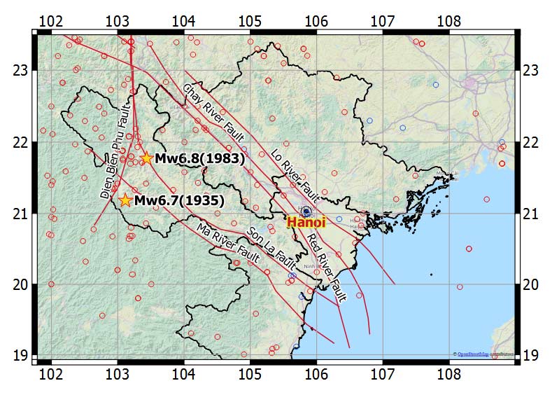
Four years ago, when I was traveling by train from Hanoi to Lao Cai in northern Vietnam and from there crossed the border into China, I wasn't aware that my journey was along a very important geological landmark that marks the junction of the Indochina (Sunda) plate, on which most of Southeast Asia is located, and the South China (Yangtze) subplate, on which the bulk of southern China is located. The train runs beside the Red River, parallel with the Red River (Song Hong) and Chay River faults, a major strike-slip fault system that extends from Dali in China to Hanoi in Vietnam.
Vietnam in general has experienced a surge in economic growth in recent years and considerable urban migration. The northern region I was traveling in used to be a remote and quiet backwater isolated by mountains and rivers, but more and more development is occurring there now. This includes the Son La Dam—the largest hydroelectric dam in Southeast Asia—and the possibility of a high-speed railway from Hanoi and Ho Chi Minh City in the future. The high population density and concentration of economic assets in major cities such as Hai Phong and Hanoi increase the region's exposure to seismic risk.
How great is the earthquake risk for Vietnam, given that it sits on active faults? According to Vietnam's Ministry of Natural Resources and Environment, the country as a whole experienced 134 earthquakes in the 20th century, including two that were between M8.0 and M9.0 . In recorded history, two earthquakes with estimated magnitudes of M5.0–6.0 are known to have shaken Hanoi in 1278 and 1285, an M6.5 quake occurred in the lower section of the Ma River in 1635, and an M6.0 temblor struck on the Ca River in 1821. In the past 100 years, there have been two major earthquakes of M6.0–7.0 near the province of Dien Bien in 1935 and 1983. Seismic hazard in Vietnam is mainly attributed to the Red River fault system.
Could North Vietnam Experience a Christchurch-Like Event?
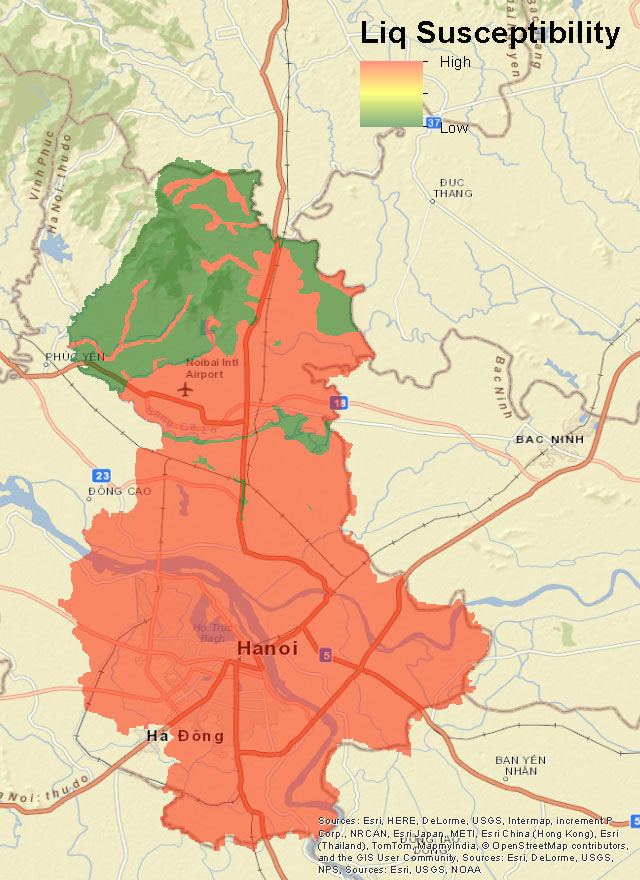
Sometimes even earthquakes of moderate strength can cause significant damage, which is what happened in Christchurch, New Zealand. The M7.1 and M6.2 earthquakes that struck Christchurch in 2010 and 2011, respectively, were wake-up calls because the region was thought to have little seismic activity, until the city was hit by a swarm of earthquakes that occurred on previously unknown faults. Because Christchurch had so many unreinforced masonry buildings (and/or buildings with insufficient detailing), and because so much of the city was built on loose sand and silt deposits—both of which are of great concern in Vietnam—there was an unprecedented amount of damage from liquefaction. Much of the Hanoi metropolitan area is located in the Red River delta on alluvial soil composed of loosely layered clay, silt, or sand, which makes it highly susceptible to liquefaction. Most buildings in Vietnam predate the introduction of seismic building codes, which makes them vulnerable to earthquakes.
The New AIR Earthquake Model for Vietnam
Until now, insurers have been using the AIR Earthquake Model for China to gauge the earthquake risk in northern Vietnam. AIR's new earthquake model for Vietnam—one of the new and updated Southeast Asia earthquake models anticipated for release in June—provides a more robust view of earthquake risk in this region. Our new model incorporates the latest historical seismicity data and fault data from local and regional sources, and new GPS data and strain rate model. It includes high-resolution soil maps and other local site characteristics to account for ground motion intensity amplification and liquefaction risks. Our new model suggests that the exceedance probability of an M6.5 earthquake occurring within 150 km of Hanoi is approximately 1% (around a 100-year return period) according to our new model. Do you truly own your Vietnam earthquake risk?