


Typhoon Vera's 50th Anniversary: How a Single Storm Prompted a Nation to Reevaluate Disaster Prevention
Sep 16, 2009
September 16, 2009
Editor's Note: This September marks the 50th anniversary of Typhoon Vera, the most destructive typhoon ever to strike Japan. A significant portion of the damage was the result of storm surge and in the years following Vera's landfall, Japan responded by fortifying the entire country against future storm surge events with a comprehensive levee system. In this article, AIR principal scientist Dr. Peter Sousounis takes a look back at Typhoon Vera and performs numerical simulations of Vera's storm surge to examine the effectiveness of Japan's subsequent mitigation efforts. AIR would like to thank Mitsui Sumitomo Insurance Company and its consulting affiliate InterRisk Research Institute & Consulting, Inc. for their support and contribution to this article.
A Most Destructive Typhoon
On the eve of the landfall of Japan's most destructive typhoon, newspaper headlines were unexceptional: "Typhoon will approach tomorrow night" and "Tokai in range of severe winds in the afternoon" are representative. The following evening, September 26th, 1959, a monstrous Category 4 storm with winds near 240 km/h came ashore west of Ise Bay in south-central Japan. The storm was dubbed Vera.1 Its record-high storm surge crashed over sea walls and breached coastal dykes that were hundreds of years old. Vera moved northeast over land toward Ise Bay, where its winds drove bay water toward Nagoya Port. The port experienced storm surge of nearly four meters at 9:35 pm local time. Dykes caved immediately, giving people in Nagoya and surrounding villages little time to flee. The city of Nagoya was devastated in just three hours; its harbor—strewn with bodies, debris and timber from a local timber factory—was subsequently described as a "sea of dead".
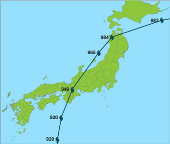
Vera tracked quickly across Honshu, losing little strength over land. In the small village of Nagano in central Japan, high winds ripped the roofs from hundreds of traditionally constructed wooden homes. Heavy precipitation swelled rivers so greatly that they spilled over their banks. Landslides were widespread. Conditions remained treacherous even after Vera's departure. Muddy water continued to pour through breaches in dykes on the south-central coast for several days until they were finally repaired. Because the area just north of Ise Bay is at or even below sea level, some districts remained flooded even 100 days after the storm.
Altogether, Typhoon Vera flooded more than 360,000 homes, of which 190,000 were submerged2 (Oda, 2006). Another 830,000 homes sustained some level of damage. The storm killed an estimated 5,000 people and injured 66,000. Much of the damage was in Aichi and Mie prefectures.

By: Dr. Peter Sousounis
Impact on Japan's Disaster Awareness and Insurance Industry
Japan is prone to natural disasters and the decade that followed World War II saw numerous large-scale events, including the Nankai earthquake in 1946, the Fukui earthquake two years later, Typhoon Tess in 1953 and Vera in 1959. These events left thousands dead, yet it was not until Vera that the situation was addressed by the government. Typhoon Vera was the catalyst for developing and strengthening the disaster management system in Japan.
On September 27th, even as Vera was still unfolding, local governments set up disaster relief headquarters and invoked the Disaster Relief Act. Refuge shelters were opened and victims were rescued using helicopters and boats. On September 29th, the national government got involved, creating the Central Japan Disaster Relief Headquarters. Defense forces joined in evacuation efforts, and truckloads of food and shelter items poured in from around the country.
Immediately after the storm, the government launched a full-force rebuilding initiative. Within a few months, the Law for Special Measures to Promote Storm Surge Protection was passed to implement measures for the protection of land and people from storm surge; other legislation addressed threats from inland flooding. Permanent restoration works began as part of a five-year plan, and two million people were put to work on the embankments of rivers and coasts. Workers built an 8-kilometer long dyke around Nagoya Port and surge defense systems were constructed on other major bays in Japan, including those in Tokyo and Osaka. These systems were designed to handle water levels based on the storm surge produced by Typhoon Vera. Measures were also put in place to reduce the rate of land sinking around Ise Bay from underground pumping activity—which had been about 10 centimeters per year by the time Vera struck.
The Disasters Countermeasures Act required annual reports on prevention-related activities and promoted public awareness through the annual observance of Disaster Prevention Day. At the local level, government officials and citizens began participating in Disaster Management Councils and drafted disaster management plans specific to their regions.
Vera's destruction marked a turning point in Japan's approach to coping with catastrophes. Previously, Japan had been response-oriented. In Vera's aftermath, the focus was on prevention. Officials invested in upgrades for disaster information communication systems, as well as improvement of weather observations and forecasting technologies.
Vera has ultimately had a tangible impact on the insurance industry. It has become the event used by insurers and reinsurers to define the reserve for a 70-year return period event. An amendment to the enforcement regulations of the Insurance Business Law on April 1, 20053, requires insurers to base their catastrophe reserves for windstorm or flood on recurrence of Typhoon Vera. This increases the minimum windstorm return period for reserving and reinsurance purposes from 20 years to 70 years.
Numerical Simulation of Vera's Storm Surge
The storm surge from Vera had a significant impact on the Ise Bay region because of shallow bathymetry, the intensity of the storm, the low elevation of the land surrounding the bay, and the lack of a resilient defense system.
To investigate the adequacy of Japan's current defense system and how it would respond to a recurrence of Typhoon Vera, AIR used a modified version of the Princeton Ocean Model (POM). The POM is a numerical grid point model capable of modeling not only ocean currents and waves in deep water, but also storm surges along coastlines. It has been used in many instances to evaluate storm surge in Japan (Minato 1998; Hong and Yoon 2003; Kohno and Higaki 2006). Although the basic model has been available for more than two decades, a relatively new feature is POM's ability to explicitly model the inland penetration and hence, the depth of the surge (Oey 2005).
To create the wind field for modeling the surge, AIR performed a simulation of Vera over water using the AIR Typhoon Model for Japan. Best Track Data from the Japanese Meteorological Agency was used to generate wind speeds and wind directions every 15 minutes, and this information was fed into POM. A normal astronomical tidal cycle was added and timed to optimally phase with the maximum storm surge at Nagoya Port.
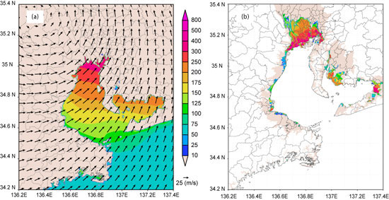
Two scenarios were modeled. The first was a recurrence of Vera (RecurVera), which is shown in Figure 2. This simulation modeled the meteorological aspects of Vera exactly as they occurred throughout the storm's lifetime and the present-day levee system around Ise Bay—but assumed widespread collapse at some point during the event. Figure 2a shows surge heights across Ise Bay at the time of maximum surge, before the levees collapsed. It is noteworthy that while the levees remained intact, they were sufficient to prevent water from overtopping and causing flooding. Impressively, the simulated magnitude and timing of the high-water mark at Nagoya Port was within 20 centimeters (higher) and 45 minutes of the observed values. This slightly higher high-water mark is likely the result of using the normal astronomical tidal cycle rather than the slightly damped one that occurred during Vera's actual landfall.
The flood footprint in Figure 2b represents the situation after the levees collapsed. The simulated inland penetration of 20 km compares well to Vera's observed flood footprint. Additionally, the greatest inland penetration in the model occurs in the region that is slightly below sea-level, which was also observed during Vera.
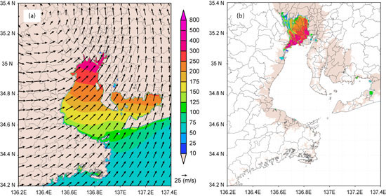
A second scenario was modeled to explore what would happen were a storm stronger than Vera to occur. From a meteorological (or central pressure) perspective, a storm as intense as Vera striking somewhere between Kagoshima and Tokyo has a return period of about 50 years. AIR's simulation took Vera's central pressure and subtracted from it 10 hectopascals, or millibars. This IntenseVera storm has an estimated return period of about 200 years. Once again, the IntenseVera simulation used the present-day levee system around Ise Bay, but this time assumed a more limited levee breach at some point during the event. The breach was imposed in the vicinity where the surge height and water velocity were greatest for this event. The astronomical tidal cycle was again phased to cause the highest surge height possible.
The surge heights across Ise Bay for IntenseVera shown in Figure 3a reveal that even though the maximum surge height is 0.4 m higher than in the case of RecurVera, an intact levee system is still adequate to keep flooding to a minimum. After the partial levee breach, however, there is a markedly different result. The flooding that results is not quite as extensive as that from RecurVera because the levee, although damaged, still provides some defense. From a loss perspective, however, it should be remembered that that there is more exposure in the region than there was in 1959. Importantly, note that the farthest inland penetration of flood water is just west of Nagoya City.
Conclusion
Storms of Vera's size and intensity will undoubtedly occur again. However, as a result of the last such experience, Japan took important steps to mitigate their effects.
The numerical surge modeling presented in this article represents research currently underway at AIR—research that will be used to enhance future releases for the AIR Typhoon Model for Japan to more accurately estimate not only the meteorological aspects of the typhoon peril, but also the mitigating effects of the technological structures in place today.
AXCO, 2009, Insurance Market Report, Japan: Non-Life (P&C), AXCO Insurance Information Services, London, UK.
Hong, C.-H., and J.-H. Yoon, 2003: A three-dimensional numerical simulation of Typhoon Holly in the northwestern Pacific Ocean, J. Geophys. Res., 108(C8), 3282, doi:10.1029/2002JC001563.
Kohno, N., and M. Higaki, 2006: The Development of a Storm Surge Model Including the Effect of Wave set-up for Operational Forecasting. Papers in Meteorology and Geophysics, Vol. 57.
Minato S., 1998: Storm surge simulation using POM and a revisitation of dynamics of sea-surface elevation short-term variation. Meteorology and Geophysics, 48, 79-88.
Non-Life Insurance Rating Organization of Japan, 1999: Report of Disaster Survey for Typhoon 9918. 54.
Oda, H., 2006: Typhoon Isewan (Vera) and its Lessons. Japan Water Forum Report, Tokyo Japan. 60 pp.
Oey, L-Y, 2005: A wetting and drying scheme for POM. Ocean Modelling, 9, 33—150.
1 The Japan Meteorological Agency, which assigns numbers rather than names to typhoons, made an exception in this case after the fact, calling it the Isewan Typhoon because of its destruction of the Ise Bay (wan) region.
2 Submersion indicates flooding to the first floor level.
3 Privatization of the Japanese insurance market didn't happen until 1996, and regulating catastrophe reserves was not a priority until nine years later, in 2005, the year after ten typhoons—more than twice the annual average—made landfall in Japan.
