


Managing U.S. Severe Thunderstorm Risk: Part 1, Reassessing the Hazard with New Data and Technologies
Nov 29, 2021
Editor's Note: AIR plans to release a substantially updated severe thunderstorm model for the United States in summer 2022. This article is the first of three in our series on managing U.S. severe thunderstorm risk. This first article discusses newly available data, technological advances, and the importance of capturing all severe thunderstorm outbreaks to successfully manage this risk. In addition, we discuss the impact of climate change on the severe thunderstorm peril. In Part II we will discuss our innovative and first-of-its-kind Hail Vulnerability Framework and how our updated model can distinguish the view of risk from one property to another. In Part III we discuss our Verisk-wide approach to looking at cat risk and non-cat risk, our validation methodology, and how companies can use their own claims experience with our model to form their own view of risk.
Severe thunderstorms are among the highest loss-causing catastrophic event types in the United States, not only because of long-lasting and intense outbreaks of hail, straight-line wind, and tornado, but also because of the cumulative effect of shorter, less intense outbreaks. To comprehensively represent severe thunderstorm risk, a catastrophe model must capture the high frequency of severe thunderstorms as well as the relatively small size of many hail, straight-line wind, and especially tornado swaths. While reports of severe thunderstorm occurrence are an important initial resource, additional data sources such as radar (for hail) and reanalysis data are critical for addressing these challenges. A robust stochastic catalog of severe thunderstorm outbreaks must capture the following: realistic frequency, location, and swath characteristics across the United States. To achieve this, the updated AIR Severe Thunderstorm Model for the United States is informed by detrended storm reports and radar data. In this article, we discuss the detrending process we use and why; how we use radar data to enhance the model’s hail hazard component; and how our model captures the full range of severe thunderstorm outbreaks, including their frequency, duration, and severity across the U.S. Importantly, we also explain the impact of climate change on the severe thunderstorm peril and finally, we discuss how to manage this risk.
Detrending Provides Near-Present View of Severe Thunderstorm Risk
The ultimate goal of a catastrophe model is to faithfully represent the risk everywhere—even in locations where exposure does not exist today—because it may exist tomorrow. An additional challenge is to build a model in such a way that it continues to faithfully represent activity over the next several years.
The AIR model was developed using storm reports from the United States Storm Prediction Center (SPC), which are point observations of severe hail, wind, and tornado occurrences. Because these observational data reflect biases, such as population growth, the expansion of urban areas, and increased ease of reporting severe weather outbreaks, these data must be detrended to remove population and reporting bias. The impacts of climate change on frequency, intensity, and other characteristics are also important to address. And, although the current state of the science and limitations in the observations preclude understanding specific climate contributions to the data, detrending the data also addresses trends that may exist from climate change, as frequencies of the past are re-defined to what they would be in the present. The detrending allows a much longer time series that can be used to build the model, which increases its stability.
AIR’s detrending methodology assumes that the last several years represent a baseline view of mean severe thunderstorm frequency, which reflects near-present climate conditions. Detrending involves bringing the earlier years up to that baseline level without changing the frequency in the more recent years. Figure 1 shows how we pivoted the raw time series of activity (in blue) using the most recent activity—which represents near-present climate and also shows stability in the mean frequency as an anchor point to produce the detrended series (in gray).
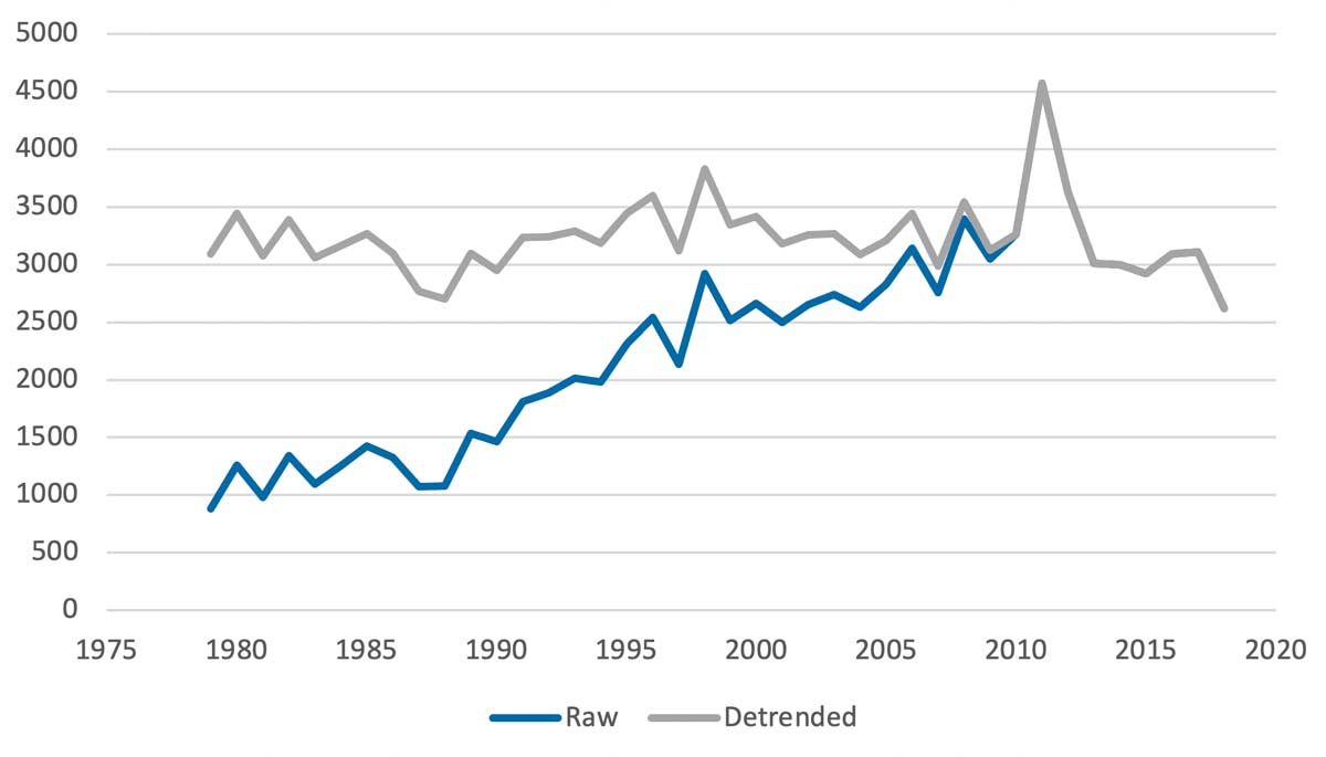
This pivot strategy simultaneously eliminates population biases and accounts for trends from climate change while preserving the interannual and multidecadal variability. Detrending the historical SPC data, along with the use of reanalysis data sets and radar data sets over the past several decades (see “Identifying Climate Change Trends box) provides a view of the severe thunderstorm risk in the U.S. in the near-present climate.
 Molly Markey, Ph.D.
Senior Scientist
 Peter Sousounis, Ph.D.
Vice President and Director of Climate Change Research
 Karthik Ramanathan, Ph.D.
Vice President
Edited by Sara Gambrill, CEEM
Leveraging Radar Data for Realistic Hail Swaths
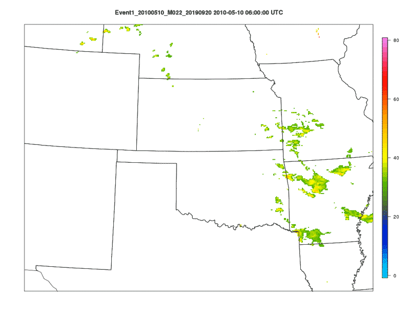
A severe thunderstorm model must capture hail swaths that are realistic not only in their length, width, and intensity but also in their regional and seasonal variation. The updated model features a hail hazard component informed by 20 years of radar data, specifically the NOAA Next Generation Weather Radar (NEXRAD Level II) radar reflectivity data for the contiguous United States on a 2-km grid at 10-minute time intervals. Using an in-house tracking algorithm, we identified more than 3 million potential hailstorms and mapped their evolution in time and space; higher reflectivity values translated into a higher potential for hail occurrence. By joining the radar-tracked storms to NEXRAD Level-III hail signatures, as well as hail reports obtained from the SPC, the Community Collaborative Rain, Hail and Snow Network (CoCoRaHS), and the Severe Hazards Analysis & Verification Project (SHAVE), we were able to filter storms by observed and radar-estimated hail size to ensure that only severe hail swaths―those with a radar-estimated hail size of 1.75 inches or a reported hail size of 0.75 inches―were kept. This process yielded thousands of radar-tracked hail swaths, capturing intensity and geometry, offering realistic year-round coverage across the contiguous United States. The animation in Figure 2 demonstrates how regions of high radar reflectivity (warm colors) are tracked through time and space to create hail swaths/footprints.
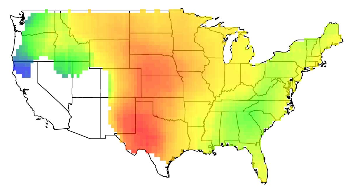
This data set was leveraged to inform the updated model’s hazard component to define length, width, and intensity probability distributions for radar-tracked hail swaths, which exhibit both realistic regional variation as well as temporal variation. Figure 3 shows mean radar-tracked hail swath length in July throughout the U.S., demonstrating that the Central U.S. experiences longer swaths, on average, than the rest of the country in midsummer. In addition, using this extensive radar data set to create the model’s probability distributions for hail swath attributes ensures that the simulated swaths are free of reporting biases, such as hail sizes being reported using objects that are close at hand or readily visualized (“quarter-size,” “golf ball–size,” etc.) rather than an actual measurement, and population biases.
The radar data also enabled us to build a daily hail probability model, which provides an enhanced view of the spatial variability in conditions favorable to hail formation in the United States to better account for regional differences. Our new daily hail probability model makes a relationship between hail observations and hail occurrence (obtained from the filtered radar reports) and individual environmental parameters that indicate hailstorm potential, such as elevation, Convective Available Potential Energy (CAPE)―a metric that approximates updraft strength and atmospheric instability―shear, and specific humidity. As a result, the AIR U.S. severe thunderstorm model’s daily probabilities for hail represent a blend between environmental conditions and observations, while also allowing for realistic interactions among variables that contribute to hail formation.
Capturing the Full Range of Severe Thunderstorm Outbreaks
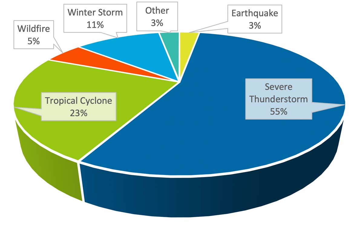
On average, 55% of annual reported industry insured losses have stemmed from severe thunderstorm events since 1985. Figure 4 shows the average annual proportion of industry insured losses attributed to severe thunderstorm events among other perils, including tropical cyclones, earthquakes, wildfires, and winter storms, as reported by Verisk’s Property Claim Services® (PCS®).
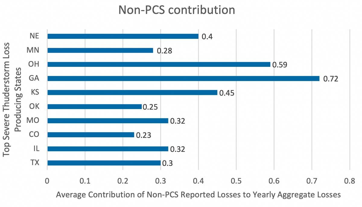
The 55% itself is a staggering contribution when it comes to severe thunderstorms, especially given the fact that PCS does not capture and report industry insured loss estimates for all severe thunderstorms. PCS captures losses solely from those severe thunderstorm outbreaks that inflict losses of greater than USD 25 million to the industry. Detailed claims data from Verisk’s Xactware® and ISO® help estimate what portion of losses are attributable to severe thunderstorms beyond those reported by PCS. Based on claims data valued at in excess of USD 200 billion over the last two decades from these sources, approximately 52% of losses can be attributed to these non-PCS severe thunderstorm outbreaks. Figure 5 shows the average contribution of non-PCS events to the yearly aggregate severe thunderstorm losses in the top 10 loss-producing states. As seen in this figure, it is evident that the share of severe thunderstorm losses could become greater if we were to look at the contribution of all severe thunderstorm events.
It is important that a model incorporate severe thunderstorm hazard from the full range of outbreak types, ranging from shorter, less intense, low loss potential outbreaks to longer, more intense, high loss potential outbreaks to ensure that an “all events” view of risk is captured.
To achieve an “all events” view the frequency of each type of outbreak, or event, in the observational data must first be quantified, then these values must be compared to these same frequencies calculated for the model. For AIR’s model, we assessed U.S. severe thunderstorm activity by calculating the number of severe thunderstorm days per year and the number of severe thunderstorm outbreaks per year.
Because severe thunderstorm outbreaks that inflict losses of greater than USD 25 million are available from Verisk’s PCS, we can use this data to assess the observed number of severe hail/straight-line wind/tornado days per year that exhibit high-loss, or “cat,” events. A time series of PCS annual number of severe thunderstorm days per year for 2000-2018 (shown in Figure 6 in green) reveals an average of 75 days per year. By definition, these are catastrophe events only; not all severe thunderstorm activity is captured by the PCS data.
To determine how many days per year exhibit severe thunderstorms of any loss-causing potential across the United States, we examined data from the Storm Prediction Center (SPC), which includes observations of severe hail, straight-line wind, and tornado for 2000-2018 in the contiguous United States. By combining the hail, straight-line wind, and tornado data and finding the number of unique days per year on which each sub-peril is observed, we created a time series of severe thunderstorm days for 2000-2018. This time series reveals that there are, on average, fully 270 severe thunderstorm days per year in the United States (shown in Figure 6 in blue).
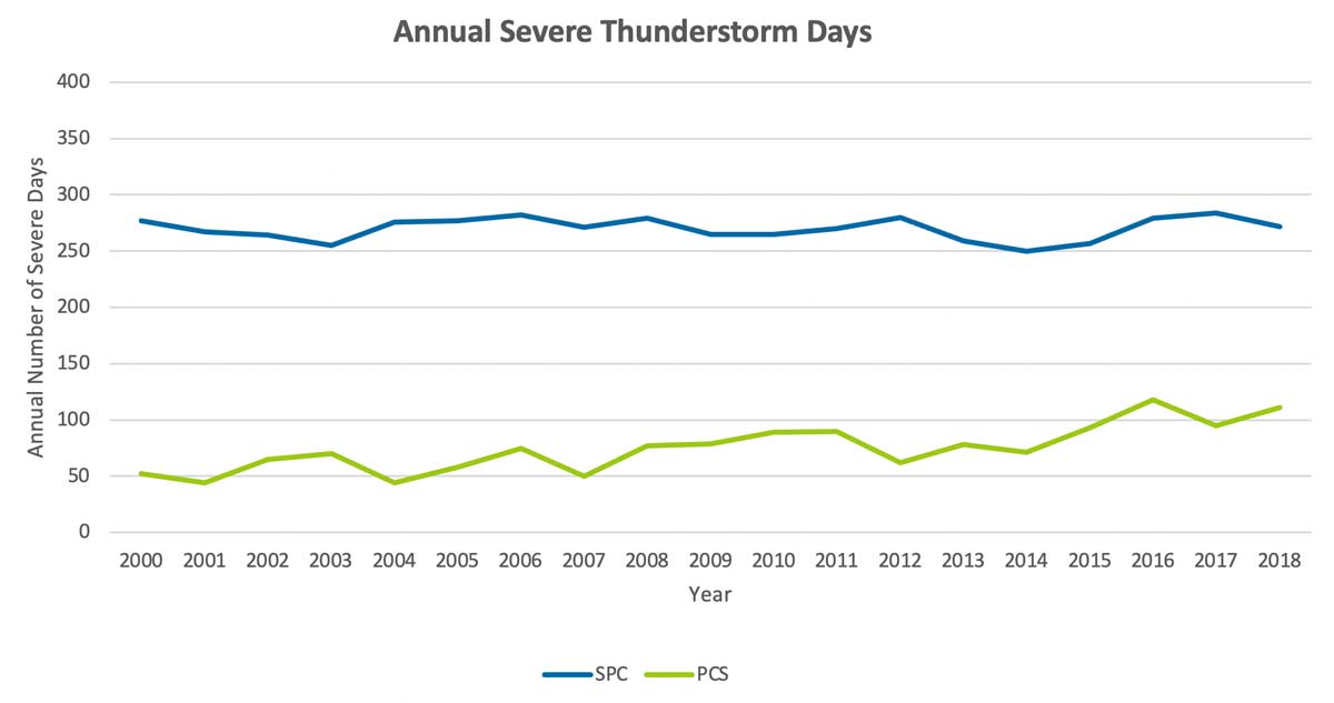
While the number of severe thunderstorm days per stochastic year in the updated AIR model’s 10,000-year “all events” catalog ranges from about 230 to 280, the average number per year across the catalog is approximately 260. This average number compares well to the average annual severe thunderstorm days observed in the SPC data. Similarly, the number of severe thunderstorm days per year in the updated model’s 10,000-year “cat events” catalog ranges from about 65 to 175, with an average value of approximately 115―a higher frequency of severe thunderstorm days than is observed in the PCS data (about 75 days per year). It should be noted that the annual number of severe days from PCS is trending upward. Although the mean is about 75 days per year for the 2000–2018 period, more recent years have higher numbers and AIR’s model provides a view for the near-present climate. It should also be noted that PCS will not report every USD 25 million event, as PCS focuses on events that are important for the industry; events with losses that are higher than USD 25 million but only affect a limited number of insurers will not necessarily be designated as PCS events.
While the PCS data are grouped by outbreak, the SPC data are not; by applying the AIR model’s macroevent algorithm to the SPC data, however, observed individual hail, straight-line wind, and tornado occurrences that form outbreaks can be grouped. The model’s macroevent algorithm features a set of daily thresholds for the number of hail, straight-line wind, and tornado swaths, as well as a threshold for the combined total number of swaths. These thresholds vary seasonally, with lower thresholds in the winter and higher thresholds in the summer―reflecting the seasonal variation seen in the observed severe thunderstorm activity. (Further note that these thresholds were determined empirically, with the goal of matching the pattern and statistics of the PCS-defined events.) If there is sub-peril activity on a day, but it does not meet any of the count thresholds, then an outbreak begins and ends on that day. If any one of the thresholds is exceeded, then that day initiates a multi-day outbreak. This multi-day outbreak continues until either 1) none of the thresholds are met on a subsequent day and the event ends or 2) the event lasts longer than 10 days and the activity on the subsequent day is less, causing the event to end.
Managing U.S. Severe Thunderstorm Risk
The updated AIR Severe Thunderstorm Model for the United States, scheduled for release in summer 2022, is designed to capture all aspects of severe thunderstorm events and outbreaks, providing a comprehensive view of severe thunderstorm risk. The updated model features stochastic catalogs of events for various use cases: all event catalogs as well as cat-only event catalogs in 10K, 50K, and 100K. The model incorporates a data set of SPC storm reports that has been detrended to better represent both the near-present climate and risk in addition to other extensive observational data sets, as well as radar data to enhance the model’s hail component. These new data sources and the new techniques employed allow the model to effectively capture high-frequency, low-loss events as well as less common, more intense severe thunderstorm outbreaks to ensure that, no matter when or where the next severe thunderstorm event or outbreak occurs, you are prepared.
References
Community Collaborative Rain, Hail & Snow Network (CoCoRaHS)
Storm Prediction Center (SPC)
Severe Hazards Analysis & Verification (SHAVE)
Next Generation Weather Radar (NEXRAD)
Nouri, N., Devineni, N., Were, V. et al. Explaining the trends and variability in the United States tornado records using climate teleconnections and shifts in observational practices. Sci Rep 11, 1741 (2021).
Tang et al., Comparison of Effective Radiative Forcing Calculations Using Multiple Methods, Drivers, and Models, 2019, J. Geophys. Res. Atmos.,V124 (8), pp. 4382-4394
