A Windy Winter Season
Feb 21, 2012
Editor's Note: Dr. Gerhard Zuba, AIR Principal Scientist, reviews the 2011—2012 windstorm season in Europe and discusses the climatological influences that lead to storm clustering.
Season Review
Although quiet and bitterly cold in later weeks, the winter of 2011—2012 has seen several damaging windstorms pass in quick succession across the European continent. These low pressure extratropical systems (also called winter storms) form when warm moist air from the subtropical region converges with cold air from the subarctic region. They track across the Atlantic and arrive in Western Europe, bringing high winds, heavy precipitation, and coastal flooding. Because windstorms are relatively fast-moving and do not lose their energy when they exit the ocean, they can cover vast expanses of land and affect several countries over the course of a few days.
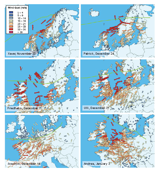
The first significant storm of the season was Xaver, which formed in the late November and brought strong winds to Scotland. High waves caused by the storm forced some oil platforms off the coast of Norway to shut down. Storm activity picked up in early December with the arrival of Friedhelm in Scotland after a process of rapid strengthening called explosive cyclogenesis. Considered Scotland's worst storm in more than a decade, Friedhelm brought violent winds to central and southern portions of the country, prompting a rare Red Alert from the U.K. Met Office. Sustained winds of over 170 km/h (105 mph, akin to a Category 2 hurricane on the Saffir-Simpson scale) were reported, with gusts exceeding 260 km/h (160 mph). Friedhelm left more than 100,000 homes without power and caused massive closures and travel disruptions. Fortunately, Scotland's wind design provisions are stringent and well enforced, and damage to the predominantly masonry building stock was not very significant.
One week later, another powerful storm struck Europe, this time affecting France, Switzerland, and Germany. Off the coast of Brittany, the winds from Joachim were so severe that a cargo ship ran aground, spilling more than 200 tons of fuel. The storm caused widespread power outages in northern and western France, with some 300,000 households losing electricity. Flooding was reported in several coastal departments. While wind speeds from Joachim were not as high as those from other major storms to affect France in recent years (like Klaus in 2009 and Xynthia in 2010, both of which caused insured losses in excess of 1 billion Euros), strong winds were recorded over much of the country and into Germany and Switzerland. This led to widespread—but mostly minor—damage, mainly to nonstructural building elements. PERILS issued an initial insured loss estimate of 300 million Euros.
A week and a half later on Christmas Day, Patrick swept through northern Scandinavia, causing tree damage, landslides, travel disruptions, and massive power outages that disrupted gas processing operations. Described as Norway's third-worst storm in the past 50 years by the Norway Meteorological Institute, wind gusts reached hurricane strength at every recording station in the country (a maximum of 233 km/h, or 145 mph, was recorded). In Finland, Patrick affected the entire south portion of the country and was the worst storm since Janika in 2001.
A few days later, windstorm Ulli formed off the coast of Newfoundland, Canada. Ulli steadily strengthened as it sped across the Atlantic Ocean, reaching Scotland with a central pressure of just 952 mb. The storm generated a sting jet—a localized strong downdraft that brings cold, dry air from the mid-troposphere down to the surface—that caused intense localized wind gusts in Scotland. Strong winds toppled trees and power lines, overturned tall trucks, and caused some damage to buildings. Ulli also brought heavy precipitation, and coastal and river flooding. The region affected by Ulli was similar to that of Windstorm Friedhelm, although Ulli's wind speeds were generally lower. Disruption to travel was widespread as roads, bridges and rail lines were forced to close.
Fast on the heels of Ulli, yet another storm—Andrea—formed southwest of Iceland on January 3 and passed to the north of the U.K., bringing strong winds to central England. As it moved southeast, Andrea intensified and struck Germany, bringing wind, rain, sleet, and snow. As is typical of storms approaching Germany from the North Sea, the storm pushed water against the coast, causing flooding in low-lying areas in the north, including Hamburg. While power outages, traffic accidents, and travel disruption were reported, structural damage from winds was limited. To date, Andrea was the last damaging storm of the season.

Storm Tracks and the NAO
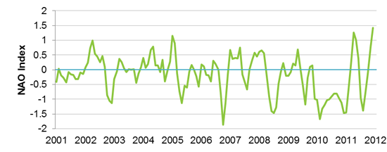
This season's storm frequency and tracks are unlike those of the previous two European winter storm seasons, which saw only one major windstorm, Xynthia, impact central Europe in the winter of 2009/10. Compared to recent years, this season saw a significant northward shift in storm tracks, resulting in an unusually high number of damaging events in northern Europe (extratropical systems typically exhibit the highest wind speeds on the right-hand side of the track, so regions south of the storm track tend to experience the most damage). This shift can be attributed to a change in the North Atlantic Oscillation (NAO) from a negative to positive phase in late 2011.

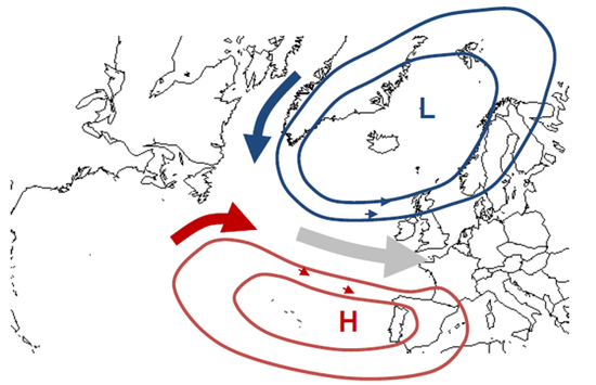
The NAO is a climate signal that influences atmospheric flow in the North Atlantic Ocean and drives much of the weather variability over parts of Europe and North America. (It is also responsible for the mild winter season this year in the U.S.) The NAO is determined by the difference in pressure between a subtropical high pressure system located near Bermuda, the Azores High, and a subarctic low pressure system located near Iceland, the Icelandic Low (see Figure 3). The clockwise rotation of the Azores High and the counterclockwise rotation of the Icelandic Low directs air eastward to Europe. The strength of this flow depends on the pressure difference between the two. A well-developed Azores High (strong high pressure) and a well-developed Icelandic Low (very low pressure) corresponds to the NAO positive (NAO+) phase. The NAO negative (NAO-) phase occurs when both systems are weak.

Under NAO+ conditions like the 2011—2012 season, extratropical cyclones tend to track toward Europe in a northeastward direction, bringing wind and precipitation to northern Europe. This has resulted in a disproportionate number of storms affecting the U.K. and Scandinavia. On the other hand, during NAO- conditions, storms tend to track due east, which takes them into the Mediterranean region. For example in 2009, which had a strongly negative NAO during the winter months, Klaus made landfall on France's Aquitaine coast, causing billions of Euros of damage in northern Spain and southern France.

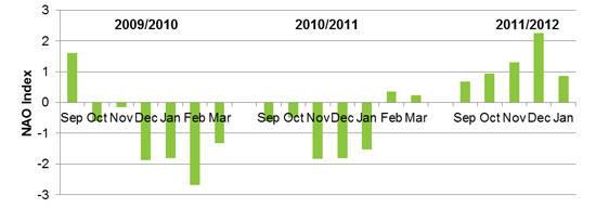
This year, as shown in Figure 4, the NAO remained positive through January, and daily indices are still showing this trend. However, no significant storms have formed after Andrea in early January, indicating that weather factors other than the NAO are influencing storm activity. Indeed, the low pressure system around Iceland has shifted westward, and continental high pressure over Russia has extended through central Europe and into parts of western Europe. This weather phenomenon is called Scandinavian blocking, whereby the high pressure that has moved over Europe is blocking storms from tracking eastward into Europe. This blocking is also causing extremely cold air from the Arctic and Russia to flow into central and western Europe. This resulted in the severe cold snap that gripped the continent—the worst in several decades—that claimed hundreds of lives since late January.
Nature Is not an Option: Modeling Storm Clusters
In addition to influencing storm tracks, NAO+ phases are also often associated with above average counts of storms, particularly over northwestern Europe, as well as the tendency for storms to follow closely on each other's heels, or cluster. Mailier et al (2005) showed that storm clustering is statistically significant in northwestern Europe at the exit region of the typical North Atlantic storm track, but not at the entrance region near North America. This suggests that storms form at regular intervals in the western North Atlantic, but that the variability in a number of large-scale climate patterns (including the North Atlantic Oscillation, the East Atlantic Pattern, and the Scandinavian Pattern) can influence their path and travel times over the Atlantic. These climate fluctuations ultimately lead to the clustered arrival of the storms in Europe.
The 2011—2012 season saw a succession of six damaging storms within a six week period, interspersed among numerous other named storms (see Table 1).
Table 1. Named storms from the 2011–2012 season; shaded rows indicate damaging events (Source: Freie University of Berlin)
| Storm Name | Date Named |
| Xaver (Berit) | November 22, 2011 |
| Yoda | November 24, 2011 |
| Zafer | November 28, 2011 |
| Arno | November 29, 2011 |
| Bob | December 1, 2011 |
| Christoph | December 3, 2011 |
| Danilo | December 4, 2011 |
| Ekkehard | December 6, 2011 |
| Friedhelm | December 7, 2011 |
| Günter | December 8, 2011 |
| Hergen | December 11, 2011 |
| Iven | December 13, 2011 |
| Joachim | December 14, 2011 |
| Klausdieter | December 17, 2011 |
| Louis | December 19, 2011 |
| Martin | December 21, 2011 |
| Norbert | December 22, 2011 |
| Oliver | December 23, 2011 |
| Patrick (Dagmar) | December 24, 2011 |
| Quirin | December 25, 2011 |
| Robert | December 26, 2011 |
| Sebastian | December 27, 2011 |
| Tilo | December 30, 2011 |
| Ulli (Emil) | December 31, 2011 |
| Andrea | January 3, 2012 |
| Bibiana | January 4, 2012 |
While this season has not packed the punch of past years with major clustered storms (like 1999's Anatol, Lothar, and Martin), it is crucial for windstorm models to be able to accurately identify individual storms, represent their size realistically, and therefore capture their temporal occurrence patterns. Clustering is a real and well-studied phenomenon, one that should not be an optional setting that can be turned on and off in the model at will.
AIR's methodology identifies storms based on their vortex centers and places them realistically within a seasonal timeline using a block-bootstrapping technique. This approach is consistent with reinsurance contracts that adopt event-based occurrence definitions, which requires clustered storms to be correctly separated according to meteorological characteristics before applying hours clauses. AIR's methodology is also ideally suited to assess the probability of having a "surplus" of damaging events in a given year because of storm clusters, compared to average expectations. This is crucial to estimating the likelihood of triggering reinstatements in reinsurance contracts.
Closing Thoughts
The current winter storm season thus far is unlikely to go down in history as an exceptional year. While several major storms have struck Europe, none of them are likely to have caused insured losses in excess of half a billion Euros. Nevertheless, the clustered arrival of this season's storms in northern Europe, which was likely influenced by a phase change in the North Atlantic Oscillation, reinforces the importance of capturing realistic storm size, frequency, and temporal occurrence patterns in a catastrophe model.
Several smaller storms within a year can cause aggregate losses that rival that of a single large storm (the so-called 20-, 50-, 100-, or 250-year, etc., events that companies typically prepare for). In such situations, excess of loss reinsurance contracts, which commonly allow for one reinstatement, may easily be exhausted or may not be triggered at all, leaving insurance companies with inadequate protection. Further, small storms are not the only ones to cluster. Storm clusters can contain one or more major events (like 1990's Daria, which was the strongest among a cluster of eight storms), which together have the potential to cause extreme windstorm losses with no historical precedence.
The AIR Extratropical Cyclone Model for Europe simulates realistic years of storm activity, faithfully preserving intraseasonal storm patterns by date-stamping each storm. Consistent with what has been observed in nature, AIR's model captures storm sizes that accurately reflect the meteorological record and explicitly allows storms to cluster, instead of treating separate clustered events as a single large storm. This is essential in providing a realistic view of occurrence and aggregate losses in accordance with actual practices in the industry.

