Windy Start to 2022
The European storm season is in full swing, with three storms impacting Europe within just a couple of days. Storm Dudley/Ylenia arrived on Wednesday the 16th of February in the UK and passed Northern Europe on the 17th with hurricane-force wind gusts that exceeded 129 km/h (80 mph). Only one day later an even stronger low-pressure system named Eunice/Zeynep caused widespread damage across much of Western and Central Europe, with particularly severe impacts in Germany. Gale-force winds of between 110 and 140 km/h (68 and 86 mph) were observed far inland and lasted for several hours. On the Isle of Wight, a gust of 196 km/h (122 mph) was measured, setting a new record in England. A third but weaker windstorm Franklin/Antonia crossed Northern Europe on the 20th-22nd of February concluding a week of turbulent weather.
Widespread Damage and Disruption
These three storms occurring in rapid succession left with a trail of damage behind in Europe, with the majority of losses being attributed to Eunice/Zeynep. More than 20 storm-related deaths have been reported across Europe, mostly as a result of fallen trees, airborne debris, and road accidents.
In the course of the six-day stretch, widespread power outages occurred in the UK and across Europe. Train services were strongly impacted in Scotland, parts of England, and the Netherlands, as well as in the northern half of Germany. Many buildings were damaged, with the O2 Arena in London and the football stadium in Den Haag being just some examples of how significant the damage was.
Verisk estimates that insured wind losses from winter storms Dudley/Ylenia and Eunice/Zeynep will range between EUR 3 billion and EUR 5 billion, the majority of which are expected in Germany, UK, and the Netherlands. These estimates reflect wind damage from Dudley/Ylenia and Eunice/Zeynep to residential, commercial, industrial, and agricultural properties, and automobiles.
Verisk’s estimate of industry insured losses also accounts for increased cost of construction observed during 2021. Based on an analysis of the current market conditions in the UK and continental Europe, Verisk estimates that losses could be increased by 10–15%. It should be noted that this 10–15% adjustment is an industry average expectation. Countries whose currency is not the Euro are showing cost increases in excess of that range. The current expectation is that prices will continue to increase and thus, any delay in the settlement of claims might result in even higher losses.
Extratropical Cyclone Clustering Is not Unexpected
Extratropical cyclones (ETC) such as Dudley/Ylenia, Eunice/Zeynep, and Franklin/Antonia form in the Northern Hemisphere mainly between October and March when warm moist air from the subtropical region converges with cold air from the subarctic region. Typically, these low-pressure systems move across the Atlantic and arrive in Western Europe, bringing high winds, and potentially heavy precipitation and coastal flooding. They can move quite fast and in contrast to hurricanes they do not necessarily lose their energy over land, which also means that they can affect a large region and several countries over the course of a few days.
Often these low-pressure systems are single events; however, storm series like last month’s are not unusual, as extratropical cyclones have the tendency to follow each other closely in time and space, if the atmospheric conditions are favorable. The most prominent examples of storm clustering in Europe that are often used as benchmarking events are the winter seasons of 1990 and 1999 with Daria & Herta (1990) and Lothar & Martin (1999); the second storm in these clusters followed the first within a short time period (within 9 and 2 days, respectively). Should such storm event clusters occur today, insured losses would be significantly higher, given the growth in exposure and value of properties and changes in insurance penetration. However, one does not have to look that far back in history to find other clustered storm events similar to last month’s: There are examples in 2015 with storms Mike and Niklas hitting Europe within just 24 hours or storms Draghi & Eberhard in 2019. Most recently, in February 2020, storms Ciara and Dennis followed by Jorge hit the UK and brought widespread flooding, just to name a few.
Storm clustering is prominent in northwestern Europe at the exit region of the typical North Atlantic storm track. There are large-scale atmospheric patterns—including the North Atlantic Oscillation (NAO)—that can influence the storm tracks and travel times. If the NAO is in a positive phase, i.e., a strong pressure gradient exists between the Icelandic low and the Azores high, there is a tendency for a strong jet stream and a northeastward movement of the low-pressure systems, bringing wind and precipitation to Northern Europe. On the other hand, during NAO negative conditions (characterized by a weak pressure gradient between Iceland and the Azores and hence a weaker jet stream), storms tend to move more south toward the Mediterranean region. NAO positive phases are also associated with above average counts of storms, particularly over northwestern Europe, as well as the tendency for storms to cluster.
So how does that relate to the recent storm events? Around the middle of January 2022 the NAO phase switched from negative to positive and the positive signal was prevailing throughout February. Hence, in combination with a strong jet stream, the atmosphere was in a favorable condition for clustering events.
Storm Clustering Is Explicitly Captured in Verisk's ETC Model
The Verisk Extratropical Cyclone Model for Europe employs a block bootstrapping methodology conditioned on the NAO phase to explicitly capture the intra-seasonal storm occurrence pattern and to preserve the tendency of storms to cluster temporally. The effect of using this methodology compared to a sampling approach using a Poisson distribution is shown in Figure 2. It shows the probability distribution of storm interarrival times compared to a re-analysis of historical data (1979 to 2015).
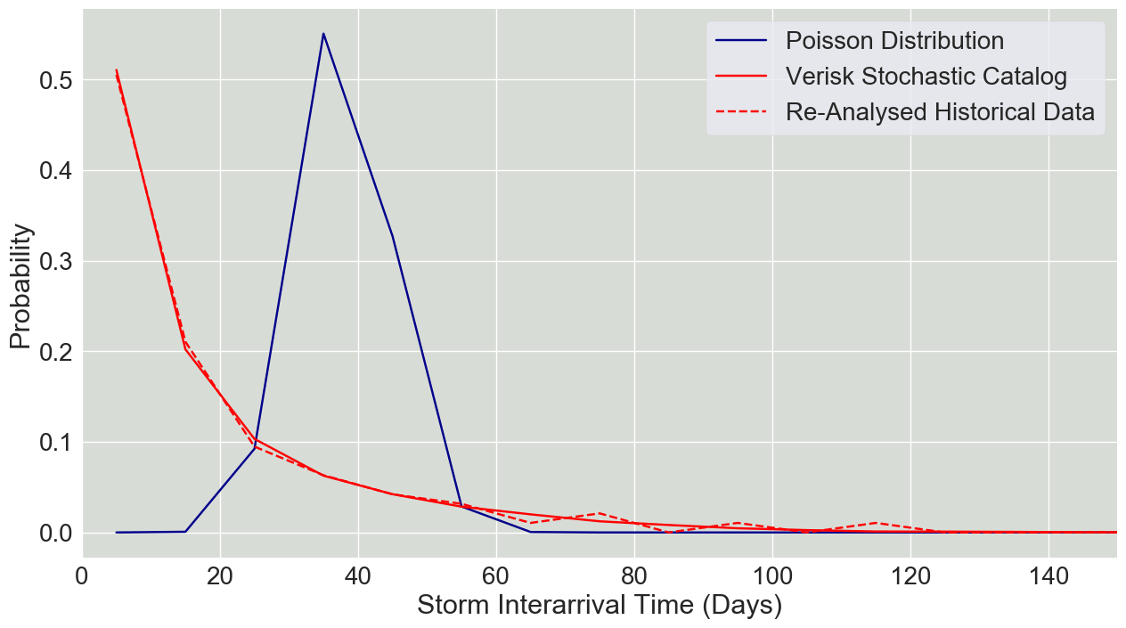
Verisk’s stochastic catalog shows good agreement with the re-analysed historical data capturing the high probability of shorter interarrival times, or clustering. The results based on the Poisson sampling, on the other hand, do not consider the clustering property of ETCs and therefore underestimate this characteristic.
Storm clusters pose an interesting scenario when it comes to event definition for claims settling. Current reinsurance contracts typically have defined hours clauses ranging between 72 and 168 hours (3 - 7 days). Given that Dudley/Ylenia and Eunice/Zeynep struck within these time ranges, Verisk expects the majority of the market to settle these two storms as a single event and policy conditions such as the retention of a reinsurance program to be applied to the combined loss.
Putting the Losses in Perspective
To put the losses for the recent events into perspective, the reported insured losses of historical clustering events have to be brought to today’s values. Verisk has included the events of the 1990 and 1999 seasons, as well as more recent examples, in the historical catalog of the extratropical cyclone model, which allows users to calculate insured losses as if these historical events were to happen today. Based on the Verisk model’s current industry exposure database and the latest take-up rate assumptions for Europe, the insured losses for these historical storms under present conditions were derived. Table 1 shows that the storm series in February 2022 , while significant, is not exceptional in terms of expected insured losses in Europe; it can be seen as a mid-sized clustering event. It is notable, however, that when looking at losses for the storms individually and not from an aggregate perspective, storm Eunice/Zeynep will not be as costly as Kyrill, but it will be within the range of Storm Friederike in 2018.
| Historical season | Clustered Extratropical Cyclones | Verisk Modelled Insured loss (EUR Bn) |
|---|---|---|
| 1990 | Daria & Herta | 14.5 |
| 1990 | Vivian & Wiebke | 8.9 |
| 1999 | Lothar & Martin | 17.0 |
| 2007 | Hanno & Kyrill | 6.6 |
| 2015 | Elon & Felix | 1.1 |
| 2015 | Mike & Niklas | 1.8 |
Managing European ETC Risk
With the storm series Dudley/Ylenia, Eunice/Zeynep, and Franklin/Antonia the year 2022 starts with notable losses for the European insurance and reinsurance market. While this is not an exceptionally large loss event in Europe’s history, it still represents another significant loss to the market after the extreme flooding in 2021.
The Verisk Extratropical Cyclone Model for Europe can help users to assess the potential impacts of individual storms as well as storm clusters similar to the recent events on their individual books. The Verisk Extratropical Cyclone Model for Europe uses the novel approach of block bootstrapping and therefore explicitly and realistically captures the intra-seasonal storm occurrence pattern. This allows you to support your (re)insurance decisions with state-of-the art loss analytics.
Do You Know Your European Extratropical Cyclone Risk?