Lahars hit the headlines in April 2021 when the La Soufrière Volcano on the Caribbean island of St. Vincent erupted, but what are they? Briefly, a lahar is a dangerous slurry mudslide composed of water, rocks, ash, and debris of volcanic origin. Smaller seasonal events of this type are sometimes referred to as "debris flows."
Lahars are chiefly associated with volcanic activity and can either be hot or cold. According to the United States Geological Survey (USGS), they usually occur on or near stratovolcanoes—conical volcanoes built up by many layers of hardened lava and other volcanic material that are exactly what most people picture when they think of volcanoes. Such volcanoes are found in the Aleutian Arc in Alaska, the Cascade Range in the Western U.S., and in many other parts of the world; lahars occur in many locations but the word is Javanese, as the phenomenon is common in Indonesia.
Erupting volcanoes can melt snow or glaciers, mix outflow with wet soil, or send volcanic material into a crater lake to trigger a lahar; shaking from earthquakes can also initiate flows. The higher up the volcano a lahar starts, the greater the gravitational potential energy it will have. The viscosity of lahars can range from a normal stream flow with a sediment concentration of less than 30% to a debris flow with a concentration above 60%; they are often described as being like wet concrete.
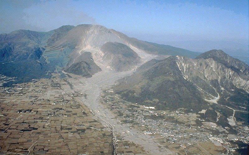
The size, speed, and content of a lahar can vary as its water and sediment supplies alter, but they generally start small and grow as they erode and accumulate material, multiplying in volume up to 10 times. Because of their mass and velocity, they can be extremely destructive to anything in their path; they can carry with them large boulders, vegetation, buildings, and bridges they have swept away. On steep slopes they can reach speeds of 120 mph or more, but they slow down as the gradients they are descending lessen; they occur with little warning and can extend as far as 50 miles from the volcano.
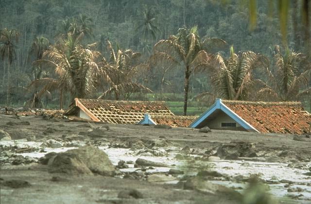
Lahars eventually slow down when they reach flatter terrain and deposit the debris they have carried with them. When these deposits constrict or block rivers, streams, or storm drains, they can cause flooding. They can also bury or partly bury buildings and may cover wide areas of agricultural land with a thick layer. Bridges that have been swept away, roads that have been blocked, and deposits too deep, soft, or hot to cross can hinder rescue attempts.
On St. Vincent in 2021 a series of massive eruptions left a substantial accumulation of volcanic ash in nearby valleys. After as much as 5 inches of rain fell in a few hours, lahars formed and flowed into some of the rivers in central and northern parts of the island. Lahars that are triggered by eruptions or are coincidental with them are termed “primary” or “syn-eruptive,” but “secondary” or “post-eruptive” lahars can also occur several years after volcanic activity as precipitation reaches and soaks more of the deposits that have been left behind. Because of the amount of ash deposited on St. Vincent and neighboring islands a lead scientist from the University of the West Indies Seismic Research Centre anticipates lahars will continue in these locations into the 2022 rainy season.
In the U.S., Mount Shasta at the southern end of California's Cascade Range and Mount Rainier in Washington State are particularly capable of generating lahars that may cause significant property damage. Because of its large amount of glacial ice, lahars are common from Mount Rainier; an immense lahar issuing from it about 5,600 years ago, for example, covered an area of 130 square miles. A huge lahar could overwhelm the Puyallup River valley below Mount Ranier where the communities of Tacoma, Fife, Puyallup, Summer, and Orting—which are all located on lahar deposits estimated to be about 500 years old—are at risk.
The USGS studies the dangers of lahars as part of its Volcano Hazards Program and monitors active volcanoes in the U.S. to warn when eruptions may be imminent. Its scientists are ready to deploy lahar-detection systems when eruptions are thought likely and maintain a permanent lahar-detection system and accompanying public notification system near Mount Rainier so that public officials can issue warnings to the communities downstream. Similar warning systems have been installed by the New Zealand Department of Conservation near lahar-prone Mount Ruapehu and in the Philippines near Mount Pinatubo, where lahars triggered by an eruption in 1991 killed more than 1,500 people.
Note that in AIR’s earthquake models the effects of landslides are not explicitly modeled; however, to the extent that modeled losses have been calibrated to and validated against actual reported losses, the impact of landslides on modeled losses is captured implicitly.
Reliably assess and manage seismic risk with AIR earthquake models