Ten years ago, on March 11, 2011, an M9.0 megathrust earthquake and tsunami struck Japan, devastating the prefectures of Iwate, Miyagi, and Fukushima. The earthquake, which shook the earth for more than five minutes, was the largest to strike the country since record-keeping began in the 1600s and the fourth most powerful ever detected worldwide. Because of the nation’s stringent building codes structures largely escaped earthquake damage, but nobody was prepared for the catastrophic tsunami that followed.
Known in Japan as the Great East Japan earthquake and to many as the Tohoku earthquake (after the region most impacted), it was considered the costliest natural catastrophe to date, according to World Bank projections. Each year 3/11 is marked in Japan, and around the world. On the fifth anniversary Kazuya Fujimura, Managing Director of AIR’s Tokyo office, blogged about his experience traveling to the region soon after the event to survey damage and the region’s progress toward recovery. And now, 10 years after the disaster, we remember once more.
The Earthquake
The megathrust earthquake occurred 370 km northeast of Tokyo and about 130 km offshore east of Honshu Island in the Japan Trench subduction zone at a depth of about 30 km (Figure 1). In this location the Pacific Plate subducts under Japan at a convergence rate of about 8 cm per year, faster than most active subduction zones in the world where megathrust earthquakes had occurred in the previous century.
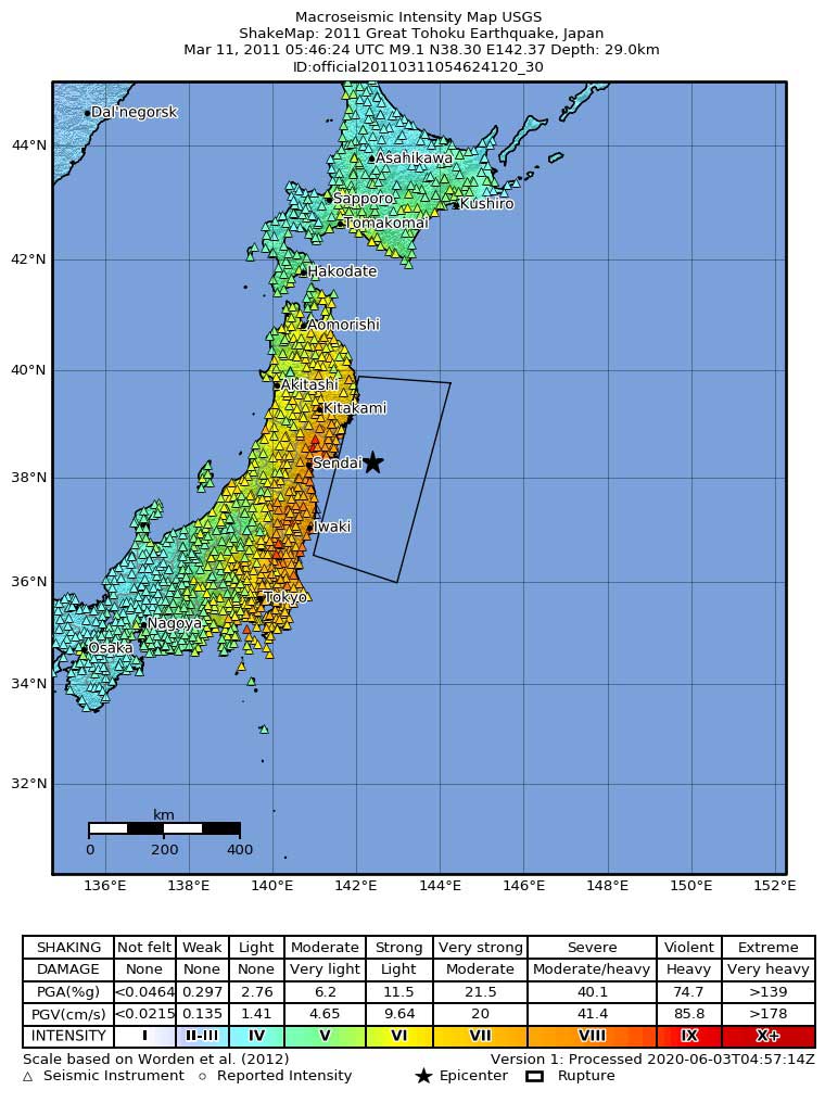
The mainshock was preceded by an M7.2 foreshock and was followed in the next six weeks by more than 1,000 aftershocks, about half of which registered M5.0 or greater (exceeding more than 10 years of prior activity in this region). In the following months and years there were yet more aftershocks. The M7.1 earthquake that rocked northern Honshu on February 13, 2021, occurred close to the subducting interface that ruptured almost exactly 10 years previously and is considered by the Japan Meteorological Agency (JMA) to have been an aftershock of the Tohoku quake.
In 2011 the M9.0 mainshock cascaded through several segments of the Japan Trench causing a rupture zone estimated at 450–600 km in length and 150–200 km in width. It released as much energy as 32,000 M6.0 temblors, shifted the axis of Earth's rotation slightly by redistributing its mass, and shortened the length of a day by about a microsecond. Shaking from the quake was felt as far away as Beijing in China and Petropavlovsk-Kamchatsky in Russia. A passing satellite was able to register low-frequency sound waves from the quake.
Based on seismic modeling results and GPS data, the horizontal movement along the plate interface was up to 25 to 30 meters near the epicentral area, representing roughly 400 years of accumulated strain. The sudden release of that strain moved the coastal area of Miyagi Prefecture eastward about 4 meters and about 400 km of its coastline downward more than 65 to 75 cm.
The Tsunami
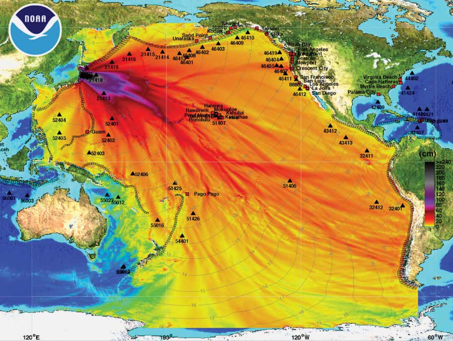
The quake also forced a 180-km stretch of seabed abruptly upward an average of 3–4 meters and as much as 6–8 meters in places. This sudden movement triggered a massive tsunami that began impacting the coast of Honshu within minutes. According to NOAA, tide gauge recordings from 75 tide stations ranged from 1 to 9 meters. In some locations, however, much higher figures were recorded. Off Kamaishi, for example, waves of 6.8 meters were observed; off Sōma, waves of 7.3 meters or higher were noted. It was estimated that the tsunami reached up to 40.5 meters in Miyako in the Iwate Prefecture, meaning run-up heights could have been even greater.
The tsunami overwhelmed both coastal defenses and the banks of the Natori River; it penetrated up to 10-km inland and inundated an area of about 560 km2. Widespread coastal flooding was experienced, particularly in and around the city of Sendai—the capital of Miyagi Prefecture and the second largest city north of Tokyo. Tsunami warnings were posted throughout the Pacific basin (Figure 2). Kauai and Hawaii in the Hawaiian Islands experienced waves 3.3 to 3.6 meters high and in the U.S. 2.7-meter waves reached California and Oregon. On the coast of Antarctica, waves about 0.3 meters high arrived some 18 hours after the quake and dislodged part of the Sulzberger Ice Shelf.
The Damage
Most of the damage incurred on 3/11 and all but about 100 of the lives lost were attributable to the tsunami rather than to the earthquake. The official total for the number of people killed stood at 18,895 as of March 1, 2018, with a further 2,539 people still missing; almost all of those lost came from Iwate, Miyagi, or Fukushima prefectures. More than 475,000 people were evacuated from the worst-hit areas. The earthquake and tsunami caused the deaths of about 4% of the region’s population—a figure kept low thanks in part to repeated evacuation drills and disaster risk management education; the 1896 Meiji-Sanriku tsunami killed 40%.
According to the Japan Reconstruction Agency, at least 120,000 buildings were destroyed, 278,000 were half-damaged, and 726,000 were partially damaged. An estimated 25 million tons of debris were generated in the three worst-affected prefectures, and another 5 million or so tons are thought to have been carried out to sea. Dams failed, electricity and water supplies were cut, and 345 fires broke out across 12 prefectures. Some 4,000 roads, 78 bridges, and 29 railways were impacted and it is estimated that about 230,000 vehicles were damaged or destroyed.
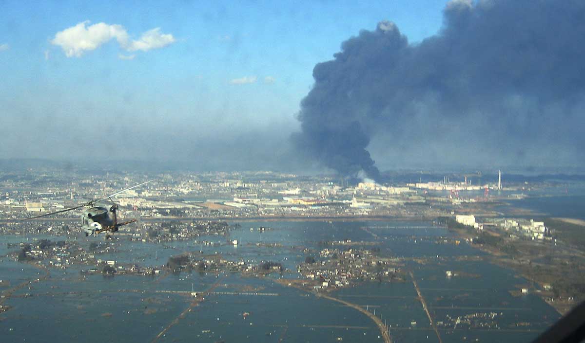
At the Fukushima Daiichi nuclear power plant, the tsunami disabled the power supply and cooling for three reactors, causing a nuclear accident in which all three cores largely melted. More than 1700 km2 were contaminated by nuclear materials and thousands of residents were evacuated from a 207 km2 exclusion zone extending northwestward from the site of the accident.
Ports closed, including 320 or so fishing ports—roughly 11% of Japan’s total, factories closed down, supply chains were seriously disrupted, and 2.6% of Japan’s farms were reportedly submerged. Roughly 6% of Japan’s economic output is ordinarily generated in the area impacted by the catastrophe. A total of 656 companies went bankrupt across the region following the catastrophe. The direct financial damage from the disaster was estimated by the Japanese government soon afterward to be about JPY 16.9 trillion (~USD 199 billion).
The scientific community, including Japan’s Headquarters for Earthquake Research Promotion (HERP) and other seismologists, had not thought it possible for such a powerful earthquake to occur in that segment of the Japan Trench. The event prompted a major reevaluation of seismic risk in the region by not only HERP but also by AIR. Tohoku was by far the most widely instrumented megathrust quake ever and provided an unprecedented wealth of ground motion data, damage observations, and detailed claims data. It had important implications for understanding the complex network of plate boundaries and crustal faults that underlie Japan's islands and highlighted the importance of explicitly modeling earthquake-associated perils like tsunami, fire and liquefaction.
Read this AIR Current to learn about managing Japan earthquake risk