In 2021, severe thunderstorm activity in the U.S. was anything but noteworthy—until December 10. The National Weather Service’s Local Storm Reports (LSRs) of straight-line winds, hail, and tornadoes were all below the annual average since 2005. Then, beginning late Friday night and lasting well into the early morning hours of Saturday, December 11, a major severe storm outbreak ripped across at least six Midwestern and Southern states.
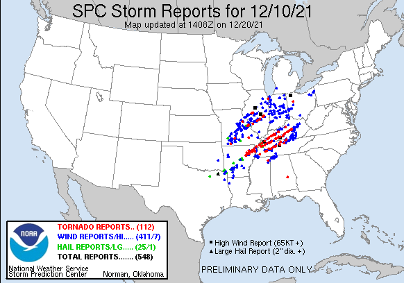
NOAA’s Storm Prediction Center has recorded 112 reports of tornados, the first arriving from Arkansas just after midnight (Figure 1). While these data are still not final and may be adjusted downward to eliminate duplicates, the outbreak will retain its place as a major historical event, not least because of the tragic loss of life and widespread destruction of homes and businesses. There is also the possibility that the outbreak gave rise to what may be the longest tornado path in U.S. history, although it will take some time for meteorologists to determine whether it was indeed cut by a single twister.
A Combination of Noteworthy Factors
But there are other things of note with respect to this tornado outbreak. For one, it occurred in December. Tornadoes can occur at any time of the year, but major outbreaks are rare in December. Rarer still in December are tornadoes of an intensity that can cause catastrophic damage. The National Weather Service said initially that the tornado that flattened Mayfield, Kentucky, was at least an EF-3, but this rating may well be increased after the completion of damage surveys.
To form, tornadoes need a lot of warm, moist, unstable air near the surface, which is the Convective Available Potential Energy (CAPE), and strong vertical wind shear over the lower half of the atmosphere. The winds not only have to increase in speed with height, but they have to change direction as well—and in a clockwise or veering fashion, with southeasterly winds near the surface, southerly winds at higher levels, and southwesterlies above that. While strong shear is common in the cold months of the year, warm, moist air is not typically found so far north in December. Earlier this month, a rapidly developing low pressure system moving from the southern Great Plains into the Great Lakes region provided the necessary ingredients: unseasonably warm moist air that surged northward from the Gulf of Mexico ahead of the storm center, an approaching cold front that lifted that air to initiate convection, and veering wind shear with height that added rotation to the supercell thunderstorms that formed, which spawned the tornadoes.
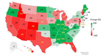
It is also noteworthy that all the factors that combined to produce this outbreak occurred farther east in the continental U.S. than is typical. Figure 2 shows an analysis we conducted recently as part of the update to the AIR Severe Thunderstorm Model for the U.S. that is anticipated for release in 2022. The graphic shows how tornado activity has shifted eastward over the course of the last 40 years. Kentucky has seen the greatest increase in tornado activity.
Is Climate Change to Blame?
The question whether this tragic event was the result of climate change inevitably arises. It’s an important one. Is this a harbinger of what’s to come—and of what we should be preparing for? For example, the cause for the geographic shift shown in Figure 2 may be related to climate change and, specifically, to increased warming of the Gulf of Mexico and tropical Atlantic Ocean, allowing warmer and moister air to be transported into the eastern and midwestern portions of the U.S. more readily and over a longer season.
I discussed the relatively new branch of climate change science called “extreme event attribution” in an AIR Current. Until very recently, most event attribution studies attempted to determine the impact of climate change on classes of events: tropical cyclones, wildfires, severe thunderstorms, or floods. But interest continues to increase in quantifying the influence on individual events.
Unfortunately, severe thunderstorms pose a particularly challenging problem for climate scientists. These storms need a lot of CAPE to fuel them and wind shear to tilt the storms vertically so that they can be long lived. Trying to make sense of how climate change influences tornadoes in a holistic way is not helped by the fact that current climate (i.e., general circulation) models cannot explicitly simulate the actual small-scale events, be they hail, tornado, or straight-line wind. But the models can simulate large air masses and the necessary ingredients for tornadoes.
While climate change seems to be increasing CAPE because of increased warming near the ground, it may be weakening vertical wind shear because the Arctic is warming faster than the tropics. Thus, for any individual event, it is still difficult to say whether climate change played a role; knowing how the ingredients have been changing is not enough. The ingredients only account for the potential for tornadoes to develop—not the certainty that they will.
Counterfactual modeling studies are helpful to paint a picture of what conditions might have been like today in the absence of increasing greenhouse gas emissions. Comparing model results with and without increased CO2 in the atmosphere can shed light not only on the ingredients, but on how the triggering mechanisms that initiate convection would differ. Counterfactual studies show promise for quantifying the impacts of climate change on actual events. These types of studies have been performed recently for heavy rainfall events such as Hurricane Harvey and coastal flooding events such as Hurricane Sandy. They have yet to be performed on more complex and even smaller-scale events like severe thunderstorms.
Future climate simulations do show that even though wind shear will decrease in general, there will be a net increase in days when high CAPE is juxtaposed with weaker shear; it is really the product of the two that matters. A consequence of that is a longer severe thunderstorm season. A recent study found that increases in severe storms capable of producing tornadoes during the fall and winter months would be most significant—about a 20% increase per degree Celsius of warming.
Despite the complexities and limitations of the current state-of-the-art climate models, they remain our best tool for quantifying expected impacts from climate change, and counterfactual studies using these models remain a sound strategy for isolating the impacts on individual events. Such a study may be forthcoming soon, and if and when that happens, I will be sharing those results in another blog.
Read the AIR Current “Using AIR’s New Modeling Framework to Understand Climate Change Impacts”