


November in Tuscany means heavy storms and intense rainfall—and the potential for flooding. The most catastrophic flood in recent memory devastated the city of Florence on November 3 and 4, 1966, killing at least 32 people and causing immense damage to irreplaceable cultural heritage.
The region began to experience steady precipitation in September and it increased in October, saturating soils. On November 2 Monte Falterona, southeast of Arezzo, received 17 inches within 24 hours, and in 48 hours Florence received a third of its annual rainfall. Early snowpack melted, adding to the water flowing westward from the Apennine Mountains to the Ligurian Sea. The Arno, the largest river in the region, begins as a stream in Monte Falterona and flows for 150 miles (240 km) through a 3,200 square mile (8,200 km2) drainage basin fed by its many tributaries. Normally shallow, its flow is irregular and can vary greatly; it is capable of changing swiftly from a low volume to near flood.
On the afternoon of November 3 a bad storm struck and the level of the Arno started to rise; towns and villages north of Florence began to flood. People climbed to the roofs of their homes to escape the rising waters, calls for help began, and the first fatality occurred. But no flood warnings were issued and no measures were taken to protect the City of Florence or its inhabitants.
Water began to overflow at the La Penna dam and downstream at the Levane dam; fearing for the dams’ integrity, engineers started discharging water into the Arno at the rate of more than 71,000 cubic feet (2,000 cubic meters) of water per second. As the enhanced mass of water reached the city moving at a speed of 37 mph (60 km/h), cellars in the Santa Croce and San Frediano districts of Florence began to flood. By about 1 a.m. on November 4 the Mugnone, a tributary of the Arno, had burst its banks and by 4 a.m., water had breached the embankments on both sides of the river and was beginning to flood the city streets.
Gas, electricity, and water supplies to affected areas were soon being cut off and by 9 a.m. the last remaining source of electric power in the city had failed. Water and soil washed downstream and surged through the streets whose narrow width increased the flow depths and velocity; these waters also ruptured heating oil tanks and added their fuel to the unwholesome mix inundating the city.
The iconic Ponte Vecchio (old bridge)—itself rebuilt after a flood in 1345—miraculously managed to withstand the flow of water even though debris, including the trunk of a massive tree, accumulated above its arches. Water surged through many of the jewelers’ shops that line the bridge; fortunately, most of the retailers had already evacuated their stock after a night watchman raised the alarm. Bridges across the river were rendered impassable by the flood, cutting one side of the city off from the other.
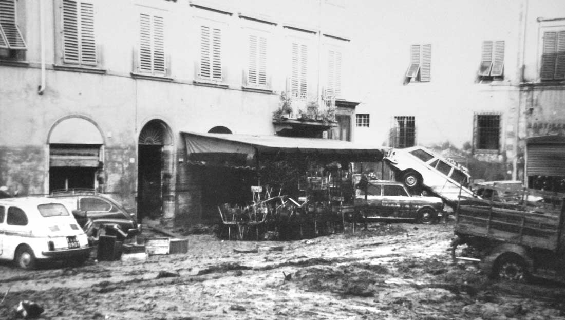
At their peak the floodwaters reached more than 22 feet (6.7 meters) deep in the Santa Croce area and, according to one estimate, covered an area of about 7,000 acres. It was not until 8 p.m. that the waters began to recede, leaving behind them 600,000 tons of thick contaminated mud and catastrophic damage. In addition to the countless works of art, rare books, and documents damaged, 26,000 homes were lost, 15,000 cars were destroyed, and 6,000 retail businesses closed for good. Recovery took decades.
The amount of precipitation that fell in a short space of time, the saturated soils, and the volume of water in the river only partially explain the flood. Man-made infrastructure such as roads and bridges constricted the flow of the river or served as conduits that enabled floodwater to inundate the floodplain with great force. As it passes through Florence, for example, the Arno is confined within embankments 25-feet high that could not contain the volume of water gushing between them.
Although it was the heartbreaking destruction within Florence that made the headlines in 1966 and is still remembered today, the whole of Northern Italy was impacted by precipitation and flooding. Downstream from Florence, for example, Santa Croce, Castelfranco, Pontedera, and Pisa were flooded. To the south, Grosseto and Maremma were inundated when the Ombrone River broke its banks, and on the other side of the country heavy precipitation contributed to the major flooding in Venice.
The 1966 flood in Florence was no outlier. In 1761 the engineer Ferdinando Morozzi dal Colle listed 56 Florentine floods documented since record-keeping started in 1177 and noted that there was a “medium” flood every 24 years on average, a “big” flood every 26 years, and an “extraordinary” flood every 100 years. Florence’s flood in 1966 was preceded by catastrophic floods in 1333 and 1844—both of which, remarkably, also occurred on November 4. Minor floods have occurred 13 times within the last 20 years.
Fortunately, the construction of new dams upstream from Florence since 1966 should provide the city with enhanced protection. But Italy in general has a history of catastrophic flooding. A high—and growing—proportion of its population lives on floodplains and flood insurance take-up rates are extremely low, particularly in southern parts of the country. Because sophisticated tools are necessary to realistically capture such inland flood risk, AIR is developing a comprehensive probabilistic catastrophe flood model for Italy, anticipated for release in 2023.
Read the blog “Devastating European Floods Test Resilience“


