Japan lies in one of the most seismically active regions in the world, with many low- to moderate-intensity tremors taking place each year. Significant destructive earthquakes—some exceeding magnitudes of 8.0—strike several times each century. In addition, many areas along Japan’s coastline may be significantly affected by tsunamis of 10 meters or higher, depending on the topography of the area, and subsequent flooding can affect areas farther inland than expected. Two particularly significant earthquakes occurred on the same date, one in 1707 and the other in 1891.
The 1707 Hoei Earthquake
The earthquake and tsunami that occurred on October 28, 1707, was the largest earthquake event in Japan’s recorded history until 2011, when the country was struck by the Mw 9.0 Tohoku event. The Hoei earthquake is still the only event known to have ruptured all segments of the Nankai Trough simultaneously and is widely believed to have triggered the most recent eruption of Mount Fuji, which followed weeks of seismic activity on December 16, 1707. The earthquake takes its name not from its location, but from the historical Hoei era (March 1704 to April 1711) in which it occurred.
The Mw 8.7 earthquake struck south-central Japan rupturing the ~500 km long subduction interface between the Eurasian and Philippine Sea plates along the Nankai Trough. It killed about 5,000 people and destroyed some 29,000 homes with the most significant damage in Honshu, Shikoku, and southeastern Kyushu. The city of Osaka was particularly badly damaged.
The earthquake also triggered a tsunami along Kochi’s southwestern coast, causing many thousands of additional deaths. Tsunami heights reached 7 to 10 meters in many places and its maximum height is believed to have been approximately 25 meters. In addition to the tsunami, the earthquake caused a significant amount of liquefaction, traces of which are still visible in the Nara Basin. It also triggered severe landslides including the Ohya landslide in Shizuoka, which covered 1.8 km2 and remains the largest landslide known to have occurred in Japan.
If a similar earthquake occurred today it could potentially devastate prefectures along Nankai Trough; the AIR model indicates that the highest shake-related losses would be in Shizuoka followed by Aichi. The earthquake is, therefore, of great interest to researchers and, while factual information is scarce, the remaining historical evidence of damage and intensity has proven to be extremely valuable.
The 1891 Nobi Earthquake
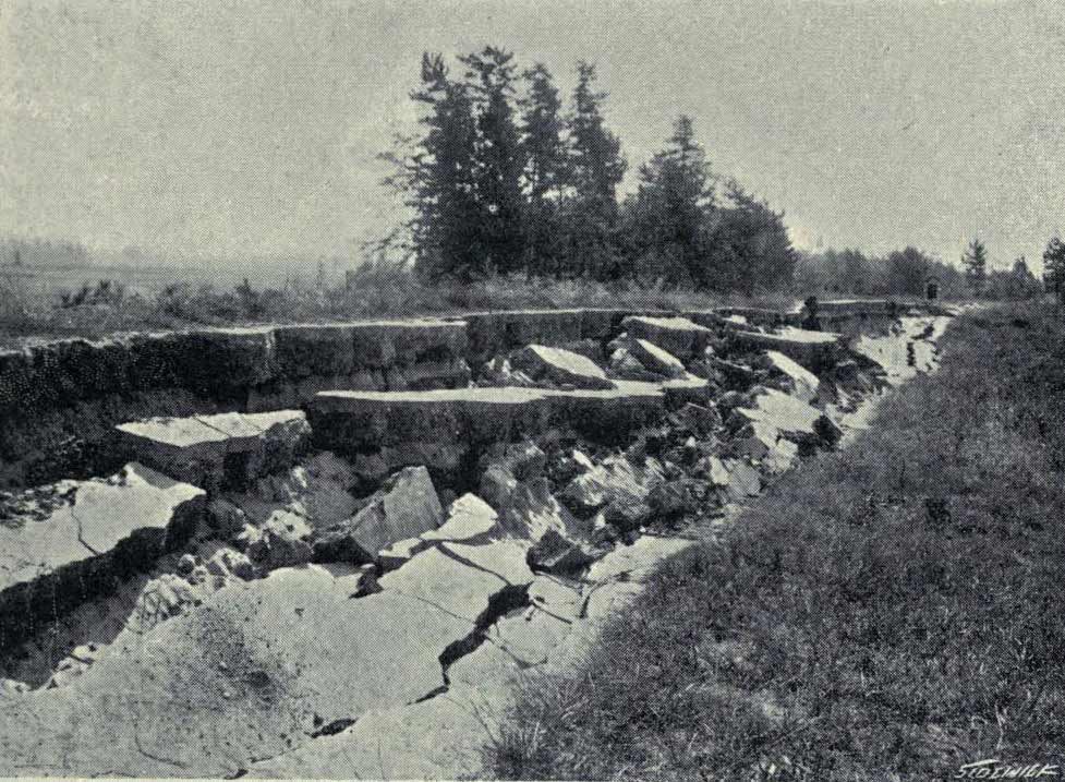
Also known as the Mino-Owari earthquake, this Mw 8.0 disaster, which occurred on the early morning of October 28, 1891, is the largest earthquake known to have occurred in Japan’s interior. The earthquake struck the Nobi region located north of Nagoya, in today’s Gifu Prefecture on Honshu, Japan’s main island. It caused a huge rupture along the Neodani Fault System, leaving one side of the Neodani Fault approximately 6 meters higher than the other (Figure 1). Strong shaking was felt across Honshu Island, from Tokyo to Osaka, spanning an area of 4,200 square miles according to the United States Geological Survey.
The shallow earthquake (8 km) caused an enormous amount of damage across four prefectures: Gifu, Aichi, Shiga, and Fukui. The city of Ogaki, located in the northwest area of the Nobi Plain in Gifu Prefecture, was close to the epicenter and destroyed. More than 7,000 people were killed, and the combination of heavy shaking and fires destroyed at least 140,000 homes and left about 100,000 people homeless. The first damage reports emerged from the cities of Osaka, Nagoya, and Kobe and indicated extensive damage, principally to modern western-style brick and masonry buildings, fueling concerns about foreign building styles. When information from rural areas became available, however, it became evident that at least 80,000 traditional wood homes had also been damaged or destroyed.
With Japan in the process of westernizing and modernizing this earthquake became the subject of scientific study. An improved understanding of the fault scarps that earthquakes can generate resulted, for example, from field investigation of the kilometers of visible fault breaks on the Earth’s surface (Figure 1). And the development of earthquake-resistant building design codes was fostered by the government’s establishment of an Association for Earthquake Disaster Reduction Investigation in 1892.
Today, earthquake preparedness is common throughout Japan, which provides training and earthquake drills for schoolchildren, emergency services, and volunteer groups. Electronic detection systems situated on the ocean floor in Sagami Bay fulfill several precautionary functions before ground shaking reaches a locality. Some of these procedures include sending warning signals, shutting off gas mains, turning all traffic signals to the stop setting, and releasing carbon dioxide into petrol storage tanks. This high degree of preparedness is essential; seismic activity affects the entire country of Japan, but even areas that have a lower level of seismicity are at risk of being struck by a major earthquake.
Read the AIR Current, “Megathrust Earthquakes in Japan and Ongoing Earthquake Risk”