
While thunderstorms can occur virtually anywhere in the U.S., severe activity is particularly common in the Great Plains, Midwest, and Southeast. It is well known that severe thunderstorms may spawn tornadoes—rapidly rotating columns of air that are connected to the base of the thunderstorm and in contact with the ground. That severe thunderstorms may also produce straight-line winds that can inflict as much damage as moderate to strong tornadoes (and that is sometimes falsely attributed to them) is less well appreciated.
Straight-line winds occur on a variety of temporal and spatial scales, from relatively localized and short-lived downbursts that cover several square kilometers and last less than 30 minutes, to widespread derecho or squall-line events that cover many thousands of square kilometers and last for several hours. Such straight-line wind events are common during the late spring and summer months.
NOAA describes derechos as “fast-moving bands of thunderstorms with destructive winds” and notes that “winds can be as strong as those found in hurricanes or even tornadoes” and that “unlike hurricanes and tornadoes, these winds follow straight lines.” The phenomenon, pronounced "deh-REY-cho," takes its name from the Spanish word for straight because of the straight-line wind damage inflicted.
The term was first used by the meteorological community in the 1880s but did not reappear until the 1980s. For an event to be classified as a derecho the swath of wind damage must extend for more than 250 miles, have had gusts of at least 58 mph along most of its length, and include multiple well-separated gusts of at least 75 mph.
The Midwest Derecho
A derecho caused widespread damage in the Midwest on August 10, 2020, some of it catastrophic. The storm system that produced it formed early in the day in the eastern end of the South Dakota-northeastern Nebraska border area and intensified rapidly as it moved eastward across Iowa at an average forward speed of 55 mph sustaining extreme winds. Continuing through Illinois, Wisconsin, and northern Indiana winds moderated only slightly, and 17 confirmed tornadoes formed. The system continued through Michigan and western Ohio in the evening, weakening and finally dissipating as it did so, having traveled a total of about 1,000 miles.
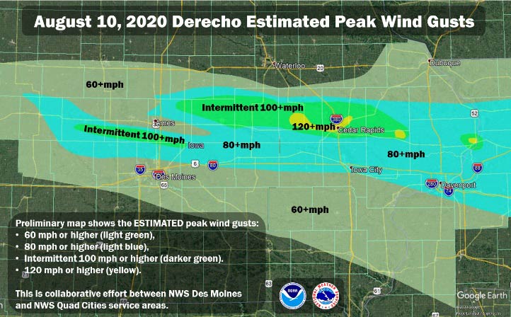
As well as heavy rainfall, winds of 110–140 mph—equivalent to Category 2-4 hurricanes—were recorded in Iowa and Illinois on August 10 and the most serious destruction occurred in these states. In Iowa, where winds in excess of 90 mph were reported throughout the state, cities such as Fairfield, Iowa City, and Des Moines experienced significant hail. Within Cedar Rapids, a city covering 75 square miles, few structures escaped harm, and many suffered catastrophic damage; thousands of the trees for which the city is known were either damaged or toppled.
Several cities in Illinois, including Alexandria, Anderson, Brownsburg, Crown Point, and West Lafayette, reported hail of up to 2 inches in diameter. Similar hail and straight-line winds were experienced in other states, including Kansas, Michigan, Minnesota, Missouri, Nebraska, Ohio, South Dakota, and Wisconsin.
In the wake of the derecho structures from outbuildings to apartment complexes were damaged, power poles snapped, and tractor trailers were blown off highways. Roads were blocked by debris and widespread tree damage led to at least 1 million households losing power for more than two weeks in some cases.
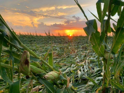
Extensive damage to barns, grain silos, and other agricultural infrastructure was reported, and widespread crop damage occurred. The storm caused much more crop damage from wind relative to hail. In a derecho, damaging wind will likely precede any damaging hail and hence be the first sub-peril that the crop encounters. Tens of millions of acres across Iowa, Illinois, Indiana, Nebraska, and Missouri and other states were impacted.
Derecho Destruction
Although they are a very different meteorological phenomenon, derechos have been referred to in the media as inland hurricanes because of the hurricane-like wind speeds and devastation that they can produce. Hurricanes, however, can be forecast days ahead and prepared for, but derechos are a rare warm weather phenomenon that can strike without warning. And the broad swath of destruction resulting from a derecho can certainly result in widespread catastrophic losses.
Referring to the storm’s impact upon Iowa, the National Weather Service noted that, “a derecho of this intensity is a roughly once-in-a-decade occurrence in this region.” The AIR Severe Thunderstorm Model for the United States can be used to estimate losses from such events. Based on our U.S. severe thunderstorm model, from the insured loss perspective, the August derecho is definitely not a frequent event for Iowa, but neither is it entirely unexpected.
Be proactive and own your risk with AIR severe thunderstorm models.