


While detailed hydraulic studies and modern flood defenses have driven advances in understanding and mitigating risk from large rivers, there is still much to be understood with respect to flood risk away from major floodplains.
Major reservoir, dyke, and renaturation projects on large rivers reduce the probability that those rivers will burst their banks and cause damage to properties on adjacent floodplains. However, there is significant flood risk away from the major floodplains where heavy precipitation combined with insufficient slope and/or poor drainage conditions cause localized or pluvial flooding. Furthermore, climate and land-use changes are exacerbating the probability of such localized flood risk, driven by intensifying precipitation rates in Central Europe and more impermeable urban surfaces.
During extreme flooding in Germany in 2013, the German Insurance Association (GdV) cited that 50% of the EUR 1.8 billion in insured losses came from regions far away from major rivers that are classified as having a very low probability of flooding. In the spring of 2016, flash flooding caused insured losses of EUR 700 million throughout Germany and particularly devastated the communities of Braunsbach and Simbach am Inn.
Flood risk away from major flood plains is obviously not the same everywhere, but how can this risk be accurately characterized and assessed?
Defining Off-floodplain or Pluvial Flooding
Off-floodplain losses typically occur when very intense rainfall causes high levels of surface runoff. This can occur at locations outside major floodplains, or within a floodplain where the river did not overflow, but property was flooded due to intense local rainfall. In urban areas, off-floodplain damage can be more frequent because the high percentage of paved areas significantly increases the runoff coefficient. Sewer backups and pump failures, insufficient drainage pipe capacities, and clogged street gutters are also common causes of off-floodplain flooding.
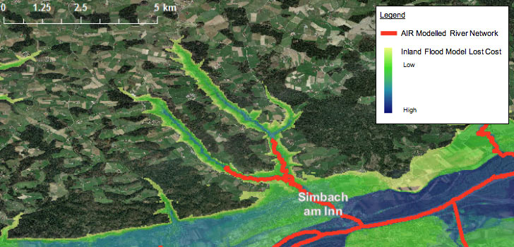
In AIR’s event-based inland flood models, such as the Inland Flood Model for Central Europe, losses on the floodplain are calculated based on depths derived from a hydraulic model, which computes water depths for each modeled flood event in the stochastic catalog. Rivers that are modeled hydraulically have a contributing catchment area of at least 10 km2. For example, the region subject to flash flooding in 2016 at Simbach am Inn (often referred to as an unpredictable, off-plain event) is captured by AIR’s on-plain hydraulically modeled river network. This area meets the 10 km2 catchment threshold. Beyond the modeled river network upstream of Simbach am Inn, flood risk is fully captured by AIR’s off-floodplain module, as visible in high-resolution lost cost maps of the area (Figure 1).
The off-floodplain hazard component is computed for all model domain locations not impacted by on-plain flooding, and great care is taken to ensure that no location is affected by both on-plain and off-plain hazard components for the same event to avoid double-counting potential losses.
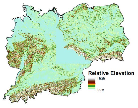
The off-floodplain or pluvial component of the AIR Inland Flood Model for Central Europe, updated this month, takes a statistical approach that correlates property damage to relative surface runoff and the relative elevation from the nearest stream or river. This approach leverages data from thousands of claims from locations outside the on-floodplain historical event footprints within the model domain.
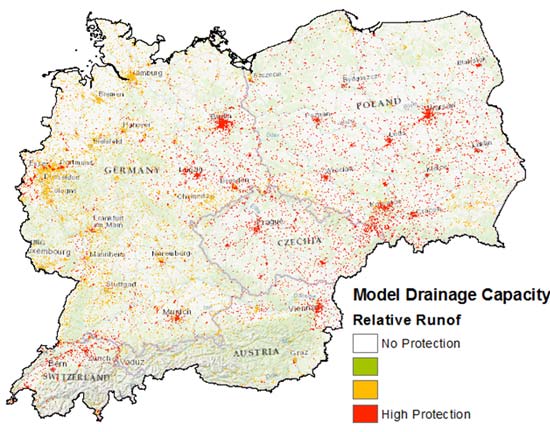
The relative surface runoff values contain the modeled output of a simulated catchment response, which explicitly accounts for modeled precipitation, infiltration, snowmelt, and antecedent soil moisture conditions. In urban areas, identified from the European Environmental Agency’s CORINE Land Cover (CLC) database, a drainage capacity grid is created to mitigate the most frequent precipitation intensities. To calculate drainage capacity of a grid cell in Europe, the model uses the relative runoff intensity corresponding to the design target, which is based on data gathered from Eurocodes on the design target capacity of storm drainage networks for urban areas (Figure 2).
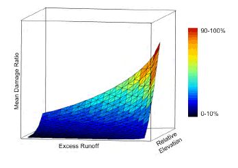
The proportion of off-floodplain properties that sustain damage within a given runoff and elevation can be illustrated using a damage surface as a function of these factors. For a given building the surface is modified based on the building’s risk characteristics (such as occupancy, construction, and height). Drainage capacity at a building’s location determines the relative runoff amount that triggers off-floodplain losses.
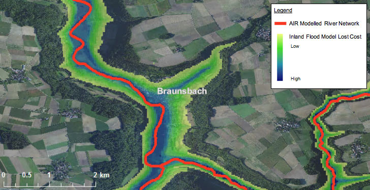
Examining AIR’s modeled river network and high-resolution inland flood loss cost maps near the community of Braunsbach, analysts can observe that flood risk in this area, which was ravaged by flash flooding in 2016, is captured by the off-plain component of the AIR model (Figure 4).
The continuity provided by the coupled on-floodplain and off-floodplain modules achieves a smooth transition between hydraulically modeled rivers and low-lying areas susceptible to pluvial flooding to provide a comprehensive view of flood risk.
Watch the video to learn more about the AIR Inland Flood Model for Central Europe


